School nearby Amal School
Jordan
School nearby Amal School
Amal School
Амман, Иордания
contacts phone
:
+962 6 566 2751
Latitude:
31.9794329
, Longitude:
35.9465535
larger map & directions
read more
nearest School
36 m
مدرسة الامل/ فرع الهاشمي
Amman
School
read more
72 m
حضانة عصافير عمان
Tareq Ben Shehab Street, Amman
School
read more
358 m
Naifeh School for Girls
Amman
School
read more
385 m
روضة أحلى الأوقات
Amman
School
read more
543 m
Abu Obeida Basic School for Boys
Amman
School
read more
552 m
Abu Obaida ( Amer Bin Al Jarah ) School
Amman
School
read more
724 m
modern basman nursery
Unnamed Road, Amman
School
read more
772 m
مسجد راشد البرايسة ابو عوده
ش. المسك،، عمّان
School
read more
774 m
المدارس المتحدة للنظم الدولية
Al-Zubaydeyah Street, Amman
School
read more
823 m
مركز الهاشمي الشمالي لتحفيظ القرآن
Amman
School
read more
841 m
Zubaydiah Secondary School for Girls
Amman
School
read more
843 m
Manar schools
Amman
School
read more
859 m
Nissan Flowers Kindergarten
Nissan Flowers Kindergarten, Dawod Adaheri St 20, Amman
School
read more
869 m
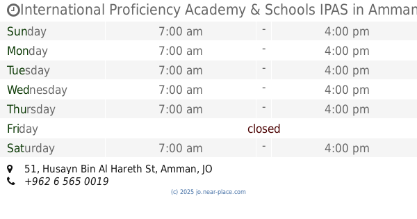
International Proficiency Academy & Schools IPAS
International Proficiency Academy & Schools IPAS, Husayn Bin Al Hareth St 51, Amman
School
read more
910 m
روضة المنال
Salman Ben Rabihah Street, Amman
School
read more
948 m
Al Shomoa Al Modea Kindergarten روضة الشموع المضيئة
Complex No 23, Al Mazeni St 23, Amman
School
read more
959 m
Al Anjal International Academy
Al Anjal International Academy, Al Badawa St 28, Amman
School
read more
959 m
مركز فارس
Amman
School
read more
966 m
Ehteraf Academy
Amman
School
read more
1.093 km
وكالة الغوث
Nahr Ad-Dan Street, Amman
School
read more
1.096 km
مدرسة ذكور الهاشمي العدادية الولى و الثانية
Amman
School
read more
1.114 km
مدرسة الوكالة الهاشمي الشمالي
Amman
School
read more
1.119 km
Agency for al-Hashemi male junior high
Amman
School
read more
1.193 km
مدرسة اناث الهاشمي
Amman
School
read more
1.236 km
مدرسة اروى بنت عبدالمطلب
Istiqlal Street, Amman
School
read more
📑
all categories
Accounting
Administrative area level 1
Administrative area level 2
Airport
Amusement park
Aquarium
Art gallery
Atm
Bakery
Bank
Bar
Beauty salon
Bicycle store
Book store
Bowling alley
Bus station
Cafe
Campground
Car dealer
Car rental
Car repair
Car wash
Cemetery
Church
City hall
Clothing store
Colloquial area
Convenience store
Country
Courthouse
Dentist
Department store
Doctor
Electrician
Electronics store
Embassy
Finance
Fire station
Florist
Food
Funeral home
Furniture store
Gas station
General contractor
Grocery or supermarket
Gym
Hair care
Hardware store
Health
Home goods store
Hospital
Insurance agency
Jewelry store
Laundry
Lawyer
Library
Liquor store
Local government office
Locality
Locksmith
Lodging
Meal delivery
Meal takeaway
Mosque
Movie rental
Movie theater
Moving company
Museum
Natural feature
Neighborhood
Night club
Painter
Park
Parking
Pet store
Pharmacy
Physiotherapist
Place of worship
Plumber
Point of interest
Police
Post office
Premise
Real estate agency
Restaurant
Route
Rv park, camping
School
Shoe store
Shopping mall
Spa
Stadium
Storage
Store
Supermarket
Taxi stand
Train station
Travel agency
University
Veterinary care
Zoo
sublocality level 1
↑