School nearby AlHussainiat School
Jordan
School nearby AlHussainiat School
AlHussainiat School
Ajloun, ירדן
contacts phone
:
+962 7 7774 4445
website:
www.salehkayyali.com
Latitude:
32.255462
, Longitude:
35.783195
larger map & directions
read more
nearest School
3.235 km
مدرسة المرج الاساسية المختلطة
طريق جرش, Ajloun
School
read more
3.535 km
مدرسة ساكب الثانوية الشاملة للبنين
Jerash
School
read more
3.72 km
مدرسة ساكب الاساسية للبنين
School
read more
3.806 km
مدرسة الصفصافة الثانوية للبنات
Ajloun, Sakib
School
read more
3.938 km
مدرسة امنه بنت وهب
Jerash
School
read more
4.24 km
Sakib Secondary School for Girls
Sakib
School
read more
4.279 km
Nahlah High school
Jerash
School
read more
4.285 km
مدرسة نحلة الثانوية الشاملة للبنات
مدرسة نحلة الثانوية الشاملة للبنات
School
read more
4.329 km
مدرسة عيصرة المختلطة
Jerash
School
read more
4.392 km
مدرسة الجزازة الاساسية المختلطة
School
read more
4.486 km
مدرسة الساخنة الثانوية للبنين
School
read more
4.737 km
Hot School Comprehensive Secondary Girls
School
read more
4.817 km
مدرسة ريمون الاساسية
Jerash
School
read more
5.074 km
Raymond High School for Girls
Jerash
School
read more
5.306 km
زياد سليمان الزيادنه
Jerash
School
read more
5.546 km
مدرسة بنات عليمون
Hizam Ring Road, Amman
School
read more
6.282 km
روضة ومدرسة الأندلس النموذجية -عجلون-عنجرة
School
read more
6.407 km
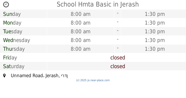
School Hmta Basic
Unnamed Road, Jerash
School
read more
6.596 km
Al-Majdal Elementary School
School
read more
8.478 km
مدرسه الملك الناصر
Ajloun
School
read more
8.799 km
مدرسه عين البستان
Kufranjah
School
read more
11.436 km
مدرسة جريش الاساسية المختلطة
Jordan
School
read more
11.704 km
مدرسة عبين عبلين الثانوية للذكور
School
read more
15.96 km
مدرسة جبا الاساسية للبنات
Jerash
School
read more
19.097 km
مدرسة ام المكمان الشمالي
School
read more
📑
all categories
Accounting
Administrative area level 1
Administrative area level 2
Airport
Amusement park
Aquarium
Art gallery
Atm
Bakery
Bank
Bar
Beauty salon
Bicycle store
Book store
Bowling alley
Bus station
Cafe
Campground
Car dealer
Car rental
Car repair
Car wash
Cemetery
Church
City hall
Clothing store
Colloquial area
Convenience store
Country
Courthouse
Dentist
Department store
Doctor
Electrician
Electronics store
Embassy
Finance
Fire station
Florist
Food
Funeral home
Furniture store
Gas station
General contractor
Grocery or supermarket
Gym
Hair care
Hardware store
Health
Home goods store
Hospital
Insurance agency
Jewelry store
Laundry
Lawyer
Library
Liquor store
Local government office
Locality
Locksmith
Lodging
Meal delivery
Meal takeaway
Mosque
Movie rental
Movie theater
Moving company
Museum
Natural feature
Neighborhood
Night club
Painter
Park
Parking
Pet store
Pharmacy
Physiotherapist
Place of worship
Plumber
Point of interest
Police
Post office
Premise
Real estate agency
Restaurant
Route
Rv park, camping
School
Shoe store
Shopping mall
Spa
Stadium
Storage
Store
Supermarket
Taxi stand
Train station
Travel agency
University
Veterinary care
Zoo
sublocality level 1
↑