Restaurant nearby Sailawi for Mansaf Restaurant
Jordan
Restaurant nearby Sailawi for Mansaf Restaurant
Sailawi for Mansaf Restaurant
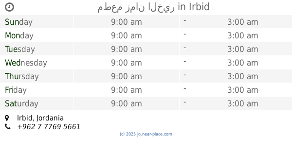
Ирбид, Иордания
contacts phone
:
+962 7 9515 8950
website:
jordan1news.blogspot.co.il
Latitude:
32.5685543
, Longitude:
35.8414099
larger map & directions
read more
nearest Restaurant
76 m
مطعم ماء الفضة
دوار فوعرا،, Irbid
Restaurant
read more
106 m
ش القدس اربد ملحمة ابو احمد
ش. القدس،، إربد
Restaurant
read more
293 m
مطعم زمان الخير
Irbid
Restaurant
read more
359 m
مطعم رصيف
Al-Quds Street, Irbid
Restaurant
read more
359 m
Alquds Restaurant
Al-Quds Street, Irbid
Restaurant
read more
359 m
مطعم القدس
Al-Quds Street, Irbid
Restaurant
read more
527 m
Plastin Resturant
Irbid
Restaurant
read more
529 m
مطعم فلسطين | كرشة وراس
Al-Quds Street, Irbid
Restaurant
read more
678 m
حلويات وبوظة السيران
حي النصر،, Irbid
Restaurant
read more
678 m
حلويات وبوظة السيران
Irbid
Restaurant
read more
683 m
مطعم حارتنا
Irbid
Restaurant
read more
865 m
Abu Habib Restaurant
Irbid
Restaurant
read more
1.002 km
مطعم شو زاكي
Irbid
Restaurant
read more
1.002 km
مطعم شو زاكي
حي العودة،, Irbid
Restaurant
read more
1.241 km
Abouda Restaurant
شارع فلسطين, Irbid
Restaurant
read more
1.393 km
Oasis Pastry
Irbid
Restaurant
read more
1.481 km
مطعم طلفاح
Al-Hashmi Street, Irbid
Restaurant
read more
1.564 km
مطعم البرنس
Al Hashmi, Irbid
Restaurant
read more
1.605 km
معجنات الباشا
Irbid
Restaurant
read more
1.61 km
Restaurant & Grills Kababjee
Irbid
Restaurant
read more
1.624 km
مطعم واصف
King Talal Street, Irbid
Restaurant
read more
1.657 km
شاورما النغش
10, Irbid
Restaurant
read more
1.693 km
Rawas Abu Awwad Restaurant
Wasi At-Tal Square, Irbid
Restaurant
read more
1.886 km
مطعم شاورما الوفاء
Irbid
Restaurant
read more
1.973 km
مطعم قوزال التركي
Irbid
Restaurant
read more
📑
all categories
Accounting
Administrative area level 1
Administrative area level 2
Airport
Amusement park
Aquarium
Art gallery
Atm
Bakery
Bank
Bar
Beauty salon
Bicycle store
Book store
Bowling alley
Bus station
Cafe
Campground
Car dealer
Car rental
Car repair
Car wash
Cemetery
Church
City hall
Clothing store
Colloquial area
Convenience store
Country
Courthouse
Dentist
Department store
Doctor
Electrician
Electronics store
Embassy
Finance
Fire station
Florist
Food
Funeral home
Furniture store
Gas station
General contractor
Grocery or supermarket
Gym
Hair care
Hardware store
Health
Home goods store
Hospital
Insurance agency
Jewelry store
Laundry
Lawyer
Library
Liquor store
Local government office
Locality
Locksmith
Lodging
Meal delivery
Meal takeaway
Mosque
Movie rental
Movie theater
Moving company
Museum
Natural feature
Neighborhood
Night club
Painter
Park
Parking
Pet store
Pharmacy
Physiotherapist
Place of worship
Plumber
Point of interest
Police
Post office
Premise
Real estate agency
Restaurant
Route
Rv park, camping
School
Shoe store
Shopping mall
Spa
Stadium
Storage
Store
Supermarket
Taxi stand
Train station
Travel agency
University
Veterinary care
Zoo
sublocality level 1
↑