Restaurant nearby Omiayaa مطعم أمية
Jordan
Restaurant nearby Omiayaa مطعم أمية
Omiayaa مطعم أمية
Wasfi At-Tal Street, Irbid Qasabah District, Irbid Governorate, JO Jordan
contacts phone
:
+962 7 9914 6000
Latitude:
32.5324277
, Longitude:
35.878129
larger map & directions
read more
nearest Restaurant
29 m
مطاعم امية
Wasfi At-Tal Street
Restaurant
read more
130 m
Shawerma Zabetny
Irbid
Restaurant
read more
286 m
Rawabi Restaurant
Rehab Brigade، إربد
Restaurant
read more
292 m
مطاعم ارابيلا
Irbid
Restaurant
read more
314 m
Alrehanah Restaurant And Cafe
Wasfi At-Tal Street
Restaurant
read more
721 m
دونر عرب
Restaurant
read more
725 m
Basket Chicken
Restaurant
read more
737 m
همبرجيني
Wasfi At-Tal Street, Irbid
Restaurant
read more
755 m
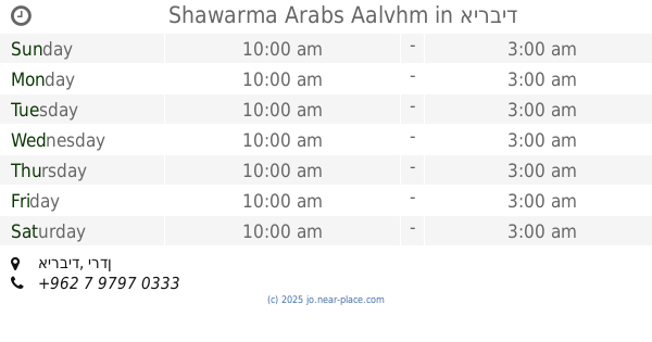
Shawarma Arabs Aalvhm
Irbid
Restaurant
read more
756 m
دجاج عصفور
Prince Hasan Street, Irbid
Restaurant
read more
758 m
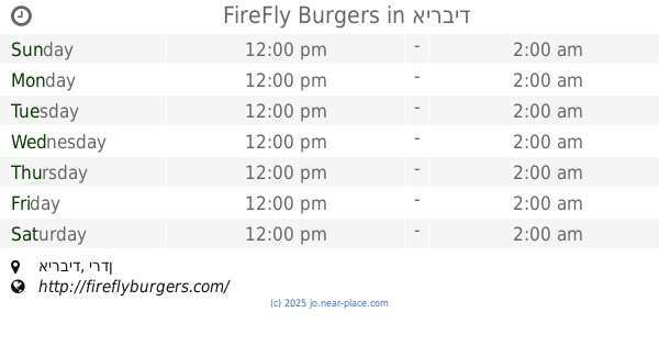
FireFly Burgers
Irbid
Restaurant
read more
773 m
مطعم زاخو 2 Zakho Restaurant
Irbid
Restaurant
read more
836 m
مطعم شرف الدين - Sharaf Al-Deen Restaurant
Wasfi At-Tal Street, Irbid
Restaurant
read more
844 m
Steak's Out
ش. التفاح،, Irbid
Restaurant
read more
854 m
Bab Sharqi
Irbid
Restaurant
read more
863 m
مطعم هاشمية الفوال
Irbid
Restaurant
read more
876 m
قاسمية الفوال 7
Irbid
Restaurant
read more
969 m
ميدان الساعة 2
Irbid
Restaurant
read more
1.014 km
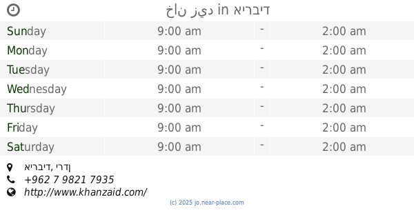
خان زيد
Irbid
Restaurant
read more
1.033 km
مطعم سرايا السلطان
Restaurant
read more
1.075 km
مطعم زنجبيل
Irbid
Restaurant
read more
1.103 km
Al Domary Restaurant
Irbid
Restaurant
read more
1.114 km
The Butcher
Unnamed Road, Irbid
Restaurant
read more
1.156 km
مطعم وملحمة أبوغياث للمأكولات الشامية
Irbid
Restaurant
read more
1.252 km
Grill Mark
makka almukrmah street, Irbid
Restaurant
read more
📑
all categories
Accounting
Administrative area level 1
Administrative area level 2
Airport
Amusement park
Aquarium
Art gallery
Atm
Bakery
Bank
Bar
Beauty salon
Bicycle store
Book store
Bowling alley
Bus station
Cafe
Campground
Car dealer
Car rental
Car repair
Car wash
Cemetery
Church
City hall
Clothing store
Colloquial area
Convenience store
Country
Courthouse
Dentist
Department store
Doctor
Electrician
Electronics store
Embassy
Finance
Fire station
Florist
Food
Funeral home
Furniture store
Gas station
General contractor
Grocery or supermarket
Gym
Hair care
Hardware store
Health
Home goods store
Hospital
Insurance agency
Jewelry store
Laundry
Lawyer
Library
Liquor store
Local government office
Locality
Locksmith
Lodging
Meal delivery
Meal takeaway
Mosque
Movie rental
Movie theater
Moving company
Museum
Natural feature
Neighborhood
Night club
Painter
Park
Parking
Pet store
Pharmacy
Physiotherapist
Place of worship
Plumber
Point of interest
Police
Post office
Premise
Real estate agency
Restaurant
Route
Rv park, camping
School
Shoe store
Shopping mall
Spa
Stadium
Storage
Store
Supermarket
Taxi stand
Train station
Travel agency
University
Veterinary care
Zoo
sublocality level 1
↑