Restaurant nearby مؤمن
Jordan
Restaurant nearby مؤمن
مؤمن
Sweileh, Amman, Jordan
contacts phone
:
+962
Latitude:
32.0155739
, Longitude:
35.8480993
larger map & directions
read more
nearest Restaurant
177 m
Al-Ashqar Restaurant
Rifaa Al-Ansari Street, Amman
Restaurant
read more
377 m
مطعم ٱزال للمأكولات اليمنية والخليجية
Amman
Restaurant
read more
403 m
Maher Restaurant
Amman
Restaurant
read more
422 m
# Jo Snack
Amman
Restaurant
read more
437 m
Al Hommosani Restaurant مطعم الحمصاني
Rifaa Al-Ansari Street, Amman
Restaurant
read more
442 m
مخبوزات Makhbozat
Rifaa Al-Ansari Street, Amman
Restaurant
read more
817 m
Annadina Restaurant
Amman
Restaurant
read more
819 m
Al Amin Restaurant
Al Baddad Commercial Complex, Queen Rania Al Abdullah St 434
Restaurant
read more
821 m
مطعم الساخن
Queen Rania Street, Amman
Restaurant
read more
826 m
مطاعم الحاج رضا فرع صويلح
Unnamed Road, Amman
Restaurant
read more
829 m
مطعم الفوال صويلح
Amman
Restaurant
read more
866 m
ertt
Ibrhim Abu Rumman, Amman
Restaurant
read more
881 m
مطعم تبولة
Queen Rania Street 425, Amman
Restaurant
read more
886 m
خآن زيد
Amman
Restaurant
read more
930 m
Castles Restaurant
Al-Aarfan Street, Amman
Restaurant
read more
939 m
الشراع الذهبي
JO, 11910 Queen Rania Street صويلح, Amman
Restaurant
read more
944 m
Mukalla Restaurant Food Yemen
Amman
Restaurant
read more
952 m
مطعم نواعير الشام
Amman
Restaurant
read more
955 m
مشاوي البكوات
عمّان
Restaurant
read more
984 m
Nidal Al Kalha Restaurants
Complex No 394, Queen Rania Al Abdullah St 394, Amman
Restaurant
read more
990 m
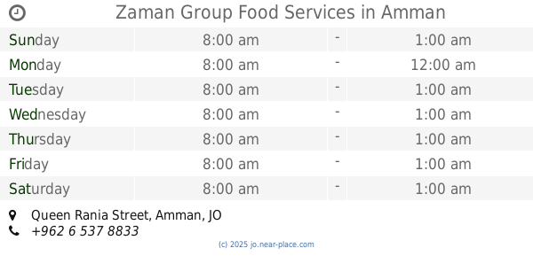
Zaman Group Food Services
Queen Rania Street, Amman
Restaurant
read more
1.004 km
Golden meal
صويلح
Restaurant
read more
1.011 km
Ammon Balat Catering Restuarant
Ersal Area Suwaileh
Restaurant
read more
1.024 km
مشاوي بابا سيد
Othman Abu Bakr Street, Amman
Restaurant
read more
1.03 km
Cherry Tut Restaurant Sweileh
Queen Rania Street, Amman
Restaurant
read more
📑
all categories
Accounting
Administrative area level 1
Administrative area level 2
Airport
Amusement park
Aquarium
Art gallery
Atm
Bakery
Bank
Bar
Beauty salon
Bicycle store
Book store
Bowling alley
Bus station
Cafe
Campground
Car dealer
Car rental
Car repair
Car wash
Cemetery
Church
City hall
Clothing store
Colloquial area
Convenience store
Country
Courthouse
Dentist
Department store
Doctor
Electrician
Electronics store
Embassy
Finance
Fire station
Florist
Food
Funeral home
Furniture store
Gas station
General contractor
Grocery or supermarket
Gym
Hair care
Hardware store
Health
Home goods store
Hospital
Insurance agency
Jewelry store
Laundry
Lawyer
Library
Liquor store
Local government office
Locality
Locksmith
Lodging
Meal delivery
Meal takeaway
Mosque
Movie rental
Movie theater
Moving company
Museum
Natural feature
Neighborhood
Night club
Painter
Park
Parking
Pet store
Pharmacy
Physiotherapist
Place of worship
Plumber
Point of interest
Police
Post office
Premise
Real estate agency
Restaurant
Route
Rv park, camping
School
Shoe store
Shopping mall
Spa
Stadium
Storage
Store
Supermarket
Taxi stand
Train station
Travel agency
University
Veterinary care
Zoo
sublocality level 1
↑