Restaurant nearby مطعم طبق السلطان
Jordan
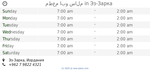
Restaurant nearby مطعم طبق السلطان
مطعم طبق السلطان
Az-Zarqa, Jordan
contacts phone
:
+962
Latitude:
32.0382889
, Longitude:
36.0773062
larger map & directions
read more
nearest Restaurant
53 m
مطعم أبو غريب
Az-Zarqa
Restaurant
read more
497 m
Wajbete Restaurant مطعم وجبتي
Az-Zarqa
Restaurant
read more
497 m
Wajbete Restaurant مطعم وجبتي
Al Malik Talal, Az-Zarqa
Restaurant
read more
513 m
Abu Issa events
Az-Zarqa
Restaurant
read more
1.049 km
Falafel King
Az-Zarqa
Restaurant
read more
1.304 km
كوماري سناك
Az-Zarqa
Restaurant
read more
1.375 km
Restaurant kebab house
الاتوستراد
Restaurant
read more
1.39 km
مطعم صاجيه ومنسف حبوب
الزرقاء،
Restaurant
read more
1.613 km
شاورما كرسبي
Army Street, Az-Zarqa
Restaurant
read more
1.613 km
مطعم وبوظة المنال
Az-Zarqa
Restaurant
read more
1.639 km
Pizza Hut بيتزا هت
Az-Zarqa
Restaurant
read more
1.642 km
Chicken Crispy Restaurant
Az-Zarqa
Restaurant
read more
1.645 km
Popeyes® Louisana Kitchen
Az-Zarqa
Restaurant
read more
1.648 km
BURGER KING
Az-Zarqa
Restaurant
read more
1.655 km
Crispy Chicken
Az-Zarqa
Restaurant
read more
1.665 km
مطعم أبو أكرم
Az-Zarqa
Restaurant
read more
1.682 km
Jasmine Sham Restaurant
شارع الجيش الاتوستراد
Restaurant
read more
1.73 km
Amazing Waffle
Az-Zarqa
Restaurant
read more
1.873 km
مطعم ابو سالم
Az-Zarqa
Restaurant
read more
1.883 km
Restaurant olive trees
الرصيفة،
Restaurant
read more
1.987 km
مطعم كريبتون
Az-Zarqa
Restaurant
read more
2.009 km
مطعم بوكي الخريف
Russeifa District, Russayfah
Restaurant
read more
2.009 km
مطعم الخريف
لواء الرصيفة،, Russayfah
Restaurant
read more
2.044 km
Ocean
Az-Zarqa
Restaurant
read more
2.522 km
شاورما كريسبي
Army Street, Az-Zarqa
Restaurant
read more
📑
all categories
Accounting
Administrative area level 1
Administrative area level 2
Airport
Amusement park
Aquarium
Art gallery
Atm
Bakery
Bank
Bar
Beauty salon
Bicycle store
Book store
Bowling alley
Bus station
Cafe
Campground
Car dealer
Car rental
Car repair
Car wash
Cemetery
Church
City hall
Clothing store
Colloquial area
Convenience store
Country
Courthouse
Dentist
Department store
Doctor
Electrician
Electronics store
Embassy
Finance
Fire station
Florist
Food
Funeral home
Furniture store
Gas station
General contractor
Grocery or supermarket
Gym
Hair care
Hardware store
Health
Home goods store
Hospital
Insurance agency
Jewelry store
Laundry
Lawyer
Library
Liquor store
Local government office
Locality
Locksmith
Lodging
Meal delivery
Meal takeaway
Mosque
Movie rental
Movie theater
Moving company
Museum
Natural feature
Neighborhood
Night club
Painter
Park
Parking
Pet store
Pharmacy
Physiotherapist
Place of worship
Plumber
Point of interest
Police
Post office
Premise
Real estate agency
Restaurant
Route
Rv park, camping
School
Shoe store
Shopping mall
Spa
Stadium
Storage
Store
Supermarket
Taxi stand
Train station
Travel agency
University
Veterinary care
Zoo
sublocality level 1
↑