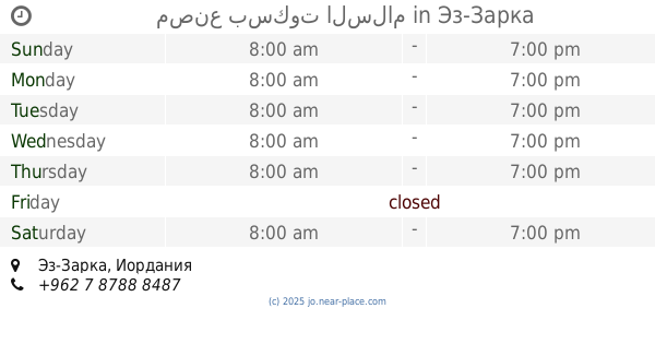
Restaurant nearby مطعم حراق بروستد / الملكاوي
Jordan
Restaurant nearby مطعم حراق بروستد / الملكاوي
مطعم حراق بروستد / الملكاوي
حي الامير عبد الله شارع الملك غازي، Az-Zarqa, Иордания
contacts phone
:
+962 7 8064 1414
Latitude:
32.0751031
, Longitude:
36.095165
larger map & directions
read more
nearest Restaurant
187 m
Sunrise Restaurant
Az-Zarqa
Restaurant
read more
220 m
Families Restaurant
Az-Zarqa
Restaurant
read more
279 m
Muwaffaq Restaurant
شارع عثمان بن عفان, Az-Zarqa
Restaurant
read more
285 m
مطعم الوليد
Az-Zarqa
Restaurant
read more
297 m
Tubasi Restaurant
Az-Zarqa
Restaurant
read more
334 m
Alaurevi Restaurant
Az-Zarqa
Restaurant
read more
351 m
Jerusalem Restaurant
Az-Zarqa
Restaurant
read more
371 m
Haj Metwally Restaurant
Az-Zarqa
Restaurant
read more
380 m
مطعم الاسراء
Az-Zarqa
Restaurant
read more
389 m
Abu Khaled Restaurant
Az-Zarqa
Restaurant
read more
508 m
مطعم الكريم
Unnamed Road, Az-Zarqa
Restaurant
read more
638 m
Restaurant a neighbor's son
Az-Zarqa
Restaurant
read more
657 m
مطعم باب الحارة
Az-Zarqa
Restaurant
read more
698 m
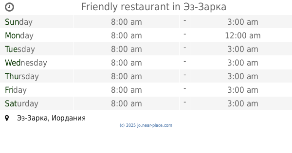
Friendly restaurant
Az-Zarqa
Restaurant
read more
731 m
First Good Restaurant
Az-Zarqa
Restaurant
read more
813 m
Balqa Restaurant
Az-Zarqa
Restaurant
read more
908 m
حلويات ابو قاسم
تقاطع شارع الامير هاشم مع شارع الامير حسن
Restaurant
read more
963 m
ماكدونالدز
Az-Zarqa
Restaurant
read more
963 m
מקדונלד'ס
Az-Zarqa
Restaurant
read more
966 m
Макдоналдс
North Of Zarqa , Al Jaysh Street, 30, Az-Zarqa
Restaurant
read more
966 m
Mcdonald's
North Of Zarqa , Al Jaysh Street, 30, Az-Zarqa
Restaurant
read more
967 m
McDonald's, Zarqa
Az-Zarqa
Restaurant
read more
1.003 km
abu Nafe
Az-Zarqa
Restaurant
read more
1.117 km
مصنع بسكوت السلام
Az-Zarqa
Restaurant
read more
1.207 km
مطعم الزهراء
Bab Al-Wad Street, Az-Zarqa
Restaurant
read more
📑
all categories
Accounting
Administrative area level 1
Administrative area level 2
Airport
Amusement park
Aquarium
Art gallery
Atm
Bakery
Bank
Bar
Beauty salon
Bicycle store
Book store
Bowling alley
Bus station
Cafe
Campground
Car dealer
Car rental
Car repair
Car wash
Cemetery
Church
City hall
Clothing store
Colloquial area
Convenience store
Country
Courthouse
Dentist
Department store
Doctor
Electrician
Electronics store
Embassy
Finance
Fire station
Florist
Food
Funeral home
Furniture store
Gas station
General contractor
Grocery or supermarket
Gym
Hair care
Hardware store
Health
Home goods store
Hospital
Insurance agency
Jewelry store
Laundry
Lawyer
Library
Liquor store
Local government office
Locality
Locksmith
Lodging
Meal delivery
Meal takeaway
Mosque
Movie rental
Movie theater
Moving company
Museum
Natural feature
Neighborhood
Night club
Painter
Park
Parking
Pet store
Pharmacy
Physiotherapist
Place of worship
Plumber
Point of interest
Police
Post office
Premise
Real estate agency
Restaurant
Route
Rv park, camping
School
Shoe store
Shopping mall
Spa
Stadium
Storage
Store
Supermarket
Taxi stand
Train station
Travel agency
University
Veterinary care
Zoo
sublocality level 1
↑