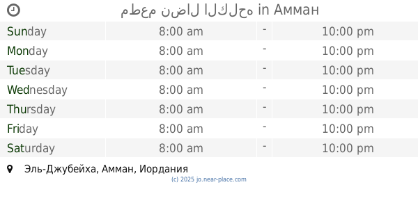
Restaurant nearby مطعم ضاحية الزيتونة
Coronavirus disease (COVID-19) Situation
confirmed cases
1746997
deaths
14122
Jordan
Restaurant nearby مطعم ضاحية الزيتونة
مطعم ضاحية الزيتونة
Omran Ben Al-Husayn Street, Amman, JO Иордания
contacts phone
:
+962
Latitude:
32.0350062
, Longitude:
35.8821034
larger map & directions
read more
nearest Restaurant
622 m
Sawarma Express
Amman
Restaurant
read more
654 m
مطاعم ومشاوي ربوع الخير
شارع ياجوز, الجبيهة, Amman
Restaurant
read more
675 m
Abu El Khair Restaurant
Yajouz Road, Amman
Restaurant
read more
751 m
Mr pizza
Yajouz Road, Amman
Restaurant
read more
963 m
Little Ceaser Pizza
Yajouz Road 104, Amman
Restaurant
read more
968 m
القيصر الصغير
Gharrafah Al-Kendi Street, Amman
Restaurant
read more
997 m
Ata Ali Restaurants
Amman
Restaurant
read more
1.029 km
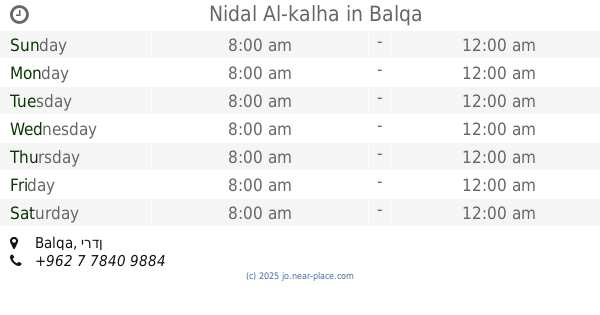
Nidal Al-kalha
Balqa
Restaurant
read more
1.059 km
Mansouri fast food
Amman
Restaurant
read more
1.116 km
Al Hommosani Restaurant
Complex No 94, Yajouz St 94, Amman
Restaurant
read more
1.123 km
Restaurant & Kitchen Anar
Amman
Restaurant
read more
1.129 km
مطعم ملحمه ومشاوي عين الفرخه
البلدية،, Amman
Restaurant
read more
1.13 km
Raouche Restaurant
Amman
Restaurant
read more
1.135 km
Abu Diab Snack
Amman
Restaurant
read more
1.148 km
مطعم بشوش
Amman
Restaurant
read more
1.149 km
BLACK FIRE
Yajouz Road 92, Amman
Restaurant
read more
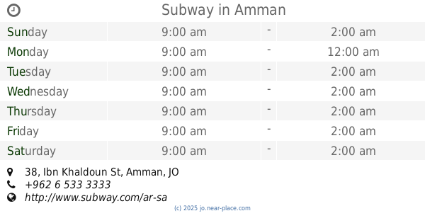
1.207 km
Subway
Plaza Al Khalidi Medical, Ibn Khaldoun St 38, Amman
Restaurant
read more
1.514 km
Myriad Restaurant Aljbhe
Umm Khelad Street, Amman
Restaurant
read more
1.694 km
Pizza Hut
Eng. Khaldoun Al Naimat Complex, Abu Nuseir St 150, Amman
Restaurant
read more
1.811 km
شاورما أبو حاتم
Karamah Street, Amman
Restaurant
read more
2.033 km
مطعم ظبي اليمن
Al-Arab Street, Amman
Restaurant
read more
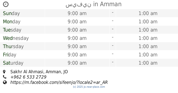
2.069 km
سيفين
Sakhr Al Ahmasi, Amman
Restaurant
read more
2.413 km
مطعم نضال الكلحه
Amman
Restaurant
read more
2.45 km
Islamic Chinese Restaurant
of, Al-Urdon Street, Amman
Restaurant
read more
2.565 km
ملحمة ومشاوي السفاريني
58,, Mahmoud Al-Kayed Street, Amman
Restaurant
read more
📑
all categories
Accounting
Administrative area level 1
Administrative area level 2
Airport
Amusement park
Aquarium
Art gallery
Atm
Bakery
Bank
Bar
Beauty salon
Bicycle store
Book store
Bowling alley
Bus station
Cafe
Campground
Car dealer
Car rental
Car repair
Car wash
Cemetery
Church
City hall
Clothing store
Colloquial area
Convenience store
Country
Courthouse
Dentist
Department store
Doctor
Electrician
Electronics store
Embassy
Finance
Fire station
Florist
Food
Funeral home
Furniture store
Gas station
General contractor
Grocery or supermarket
Gym
Hair care
Hardware store
Health
Home goods store
Hospital
Insurance agency
Jewelry store
Laundry
Lawyer
Library
Liquor store
Local government office
Locality
Locksmith
Lodging
Meal delivery
Meal takeaway
Mosque
Movie rental
Movie theater
Moving company
Museum
Natural feature
Neighborhood
Night club
Painter
Park
Parking
Pet store
Pharmacy
Physiotherapist
Place of worship
Plumber
Point of interest
Police
Post office
Premise
Real estate agency
Restaurant
Route
Rv park, camping
School
Shoe store
Shopping mall
Spa
Stadium
Storage
Store
Supermarket
Taxi stand
Train station
Travel agency
University
Veterinary care
Zoo
sublocality level 1
↑