Restaurant nearby حمادة
Jordan
Restaurant nearby حمادة
حمادة
Al Naser, Amman, Jordanien
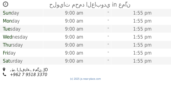
contacts phone
:
+962
website:
www.hamada.jo
Latitude:
31.9431939
, Longitude:
35.9672652
larger map & directions
read more
nearest Restaurant
43 m
ملحمة عمار
Abu Taleb Street 145،, Amman
Restaurant
read more
307 m
مطعم مجدي
Abdallah Ben Abi Jahm Street 36, Amman
Restaurant
read more
463 m
HE Restaurant
Al-Manarah Street 123،, Amman
Restaurant
read more
614 m
مطعم ايهاب
Al-Manarah Street 69, Amman
Restaurant
read more
639 m
مطعم اهل الخير
Abu Taleb Street, Amman
Restaurant
read more
674 m
Flower Lighthouse Restaurant
Amman
Restaurant
read more
898 m
مطعم الأزهر Al Azhar resturant
Amman
Restaurant
read more
910 m
Flamingo Flower Restaurants
Complex No 70, Adan St 70, Amman
Restaurant
read more
919 m
Flamingo Restaurant
Amman
Restaurant
read more
929 m
صالة الجفال لﻻحتفاﻻت
Amman
Restaurant
read more
1.217 km
Rockeries Restaurant
Abu Taleb Street, Amman
Restaurant
read more
1.397 km
مطبخ منسف البادية المركزي
النهارية،, Amman
Restaurant
read more
1.4 km
ملحمة اللبدي
Ali An-Nashashibi Street, Amman
Restaurant
read more
1.423 km
Al Arabi Restaurant
Complex No 25, Al Shuhada St 25, Amman
Restaurant
read more
1.515 km
Pizza and Pastry baker (Karim Mahmoud)
Al-Shuhadaa Street, Amman
Restaurant
read more
1.564 km
مطعم الحناين
Abdul Rahman Al-Kawakebi Street, Amman
Restaurant
read more
1.602 km
waffle bubbles
العريض, الشارع
Restaurant
read more
1.844 km
مطعم السنجلاوي للتواصي
عمان, حي, أم تينه, والباقي عندك
Restaurant
read more
1.968 km
فلافل عمان
Amman
Restaurant
read more
1.98 km
مطعم ابو لؤي
Amman
Restaurant
read more
2.227 km
مطاعم الأجنحة الشهيرة
Al-Fidaa Street, Amman
Restaurant
read more
2.36 km
حلويات محمد العابودي
ش. الفداء،، عمّان
Restaurant
read more
2.36 km
حلويات محمد العابدي
ش. الفداء،، عمّان
Restaurant
read more
2.462 km
Hamati Restaurant
Amman
Restaurant
read more
2.563 km
Bader Resturent
Amman
Restaurant
read more
📑
all categories
Accounting
Administrative area level 1
Administrative area level 2
Airport
Amusement park
Aquarium
Art gallery
Atm
Bakery
Bank
Bar
Beauty salon
Bicycle store
Book store
Bowling alley
Bus station
Cafe
Campground
Car dealer
Car rental
Car repair
Car wash
Cemetery
Church
City hall
Clothing store
Colloquial area
Convenience store
Country
Courthouse
Dentist
Department store
Doctor
Electrician
Electronics store
Embassy
Finance
Fire station
Florist
Food
Funeral home
Furniture store
Gas station
General contractor
Grocery or supermarket
Gym
Hair care
Hardware store
Health
Home goods store
Hospital
Insurance agency
Jewelry store
Laundry
Lawyer
Library
Liquor store
Local government office
Locality
Locksmith
Lodging
Meal delivery
Meal takeaway
Mosque
Movie rental
Movie theater
Moving company
Museum
Natural feature
Neighborhood
Night club
Painter
Park
Parking
Pet store
Pharmacy
Physiotherapist
Place of worship
Plumber
Point of interest
Police
Post office
Premise
Real estate agency
Restaurant
Route
Rv park, camping
School
Shoe store
Shopping mall
Spa
Stadium
Storage
Store
Supermarket
Taxi stand
Train station
Travel agency
University
Veterinary care
Zoo
sublocality level 1
↑