Restaurant nearby Al Huda Cafeteria
Jordan
Restaurant nearby Al Huda Cafeteria
Al Huda Cafeteria
Az-Zarqa Israel
contacts phone
:
+962
Latitude:
32.0638314
, Longitude:
36.0950453
read more
nearest Restaurant
122 m
Um Bashar Restaurant Krchat
26, المجمع القديم, Az-Zarqa
Restaurant
read more
174 m
NAR snack restaurant
Al-Batrwai Circle, Az-Zarqa
Restaurant
read more
223 m
شاورما الروشه
Az-Zarqa
Restaurant
read more
339 m
ملحمة ومشاوي باربيكو
Az-Zarqa
Restaurant
read more
345 m
صاجيه ومنسف
، الزرقاء ،الاوتستراد ،بجانب مستشفى جبل، الزيتون، الزرقاء،
Restaurant
read more
383 m
بوظة ضبان
Az-Zarqa
Restaurant
read more
392 m
مشاوي ابو فخر الجيزاوي
Az-Zarqa
Restaurant
read more
394 m
Filfila Restaurant
Az-Zarqa
Restaurant
read more
410 m
مطعم صحي
شارع شامل, Az-Zarqa
Restaurant
read more
412 m
مطعم عربي فرنجي
Az-Zarqa
Restaurant
read more
468 m
مطاعم عمر الزواتي
Az-Zarqa
Restaurant
read more
475 m
abu Nafe
Az-Zarqa
Restaurant
read more
557 m
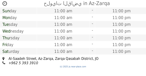
حلويات القاضي
Al-Saadeh Street, Az-Zarqa
Restaurant
read more
620 m
Moaz Snack Restaurant
Az-Zarqa
Restaurant
read more
699 m
Pizza One مطعم بيتزاون
Bab Al-Wad Street, Az-Zarqa
Restaurant
read more
706 m
مطعم الميدان
Az-Zarqa
Restaurant
read more
719 m
مطعم الزهراء
Bab Al-Wad Street, Az-Zarqa
Restaurant
read more
752 m
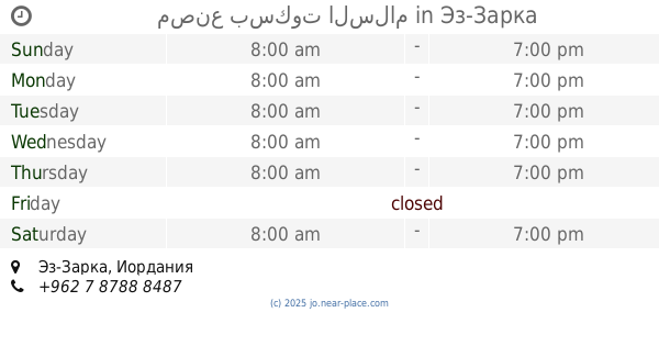
مصنع بسكوت السلام
Az-Zarqa
Restaurant
read more
790 m
مطعم با بيتزا Pa pizza
Al-Saadeh Street, Az-Zarqa
Restaurant
read more
882 m
مطعم الاسراء
Az-Zarqa
Restaurant
read more
937 m
شاورما كريسبي
Army Street, Az-Zarqa
Restaurant
read more
955 m
First Good Restaurant
Az-Zarqa
Restaurant
read more
959 m
Tubasi Restaurant
Az-Zarqa
Restaurant
read more
971 m
مطعم الوليد
Az-Zarqa
Restaurant
read more
1.011 km
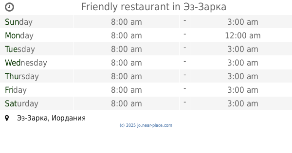
Friendly restaurant
Az-Zarqa
Restaurant
read more
📑
all categories
Accounting
Administrative area level 1
Administrative area level 2
Airport
Amusement park
Aquarium
Art gallery
Atm
Bakery
Bank
Bar
Beauty salon
Bicycle store
Book store
Bowling alley
Bus station
Cafe
Campground
Car dealer
Car rental
Car repair
Car wash
Cemetery
Church
City hall
Clothing store
Colloquial area
Convenience store
Country
Courthouse
Dentist
Department store
Doctor
Electrician
Electronics store
Embassy
Finance
Fire station
Florist
Food
Funeral home
Furniture store
Gas station
General contractor
Grocery or supermarket
Gym
Hair care
Hardware store
Health
Home goods store
Hospital
Insurance agency
Jewelry store
Laundry
Lawyer
Library
Liquor store
Local government office
Locality
Locksmith
Lodging
Meal delivery
Meal takeaway
Mosque
Movie rental
Movie theater
Moving company
Museum
Natural feature
Neighborhood
Night club
Painter
Park
Parking
Pet store
Pharmacy
Physiotherapist
Place of worship
Plumber
Point of interest
Police
Post office
Premise
Real estate agency
Restaurant
Route
Rv park, camping
School
Shoe store
Shopping mall
Spa
Stadium
Storage
Store
Supermarket
Taxi stand
Train station
Travel agency
University
Veterinary care
Zoo
sublocality level 1
↑