Restaurant nearby Abu Staef Restaurants
Coronavirus disease (COVID-19) Situation
confirmed cases
1746997
deaths
14122
Jordan
Restaurant nearby Abu Staef Restaurants
Abu Staef Restaurants
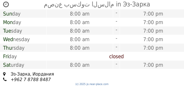
Эз-Зарка, Иордания
contacts phone
:
+962 7 7207 7301
Latitude:
32.0703682
, Longitude:
36.0889986
larger map & directions
read more
nearest Restaurant
60 m
First Good Restaurant
Az-Zarqa
Restaurant
read more
377 m
مصنع بسكوت السلام
Az-Zarqa
Restaurant
read more
428 m
Abu Khaled Restaurant
Az-Zarqa
Restaurant
read more
480 m
مطعم الزهراء
Bab Al-Wad Street, Az-Zarqa
Restaurant
read more
531 m
مطعم الاسراء
Az-Zarqa
Restaurant
read more
589 m
Tubasi Restaurant
Az-Zarqa
Restaurant
read more
606 m
مشاوي ابو فخر الجيزاوي
Az-Zarqa
Restaurant
read more
621 m
Filfila Restaurant
Az-Zarqa
Restaurant
read more
640 m
ملحمة ومشاوي باربيكو
Az-Zarqa
Restaurant
read more
648 m
مطعم با بيتزا Pa pizza
Al-Saadeh Street, Az-Zarqa
Restaurant
read more
681 m
مطعم صحي
شارع شامل, Az-Zarqa
Restaurant
read more
758 m
Restaurant a neighbor's son
Az-Zarqa
Restaurant
read more
762 m
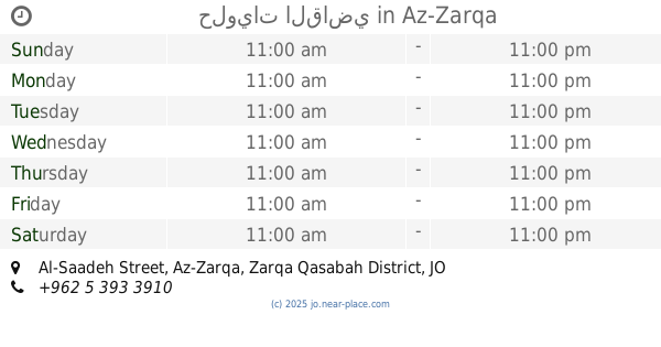
حلويات القاضي
Al-Saadeh Street, Az-Zarqa
Restaurant
read more
776 m
Pizza One مطعم بيتزاون
Bab Al-Wad Street, Az-Zarqa
Restaurant
read more
813 m
Muwaffaq Restaurant
شارع عثمان بن عفان, Az-Zarqa
Restaurant
read more
898 m
شاورما الروشه
Az-Zarqa
Restaurant
read more
901 m
بوظة ضبان
Az-Zarqa
Restaurant
read more
920 m
Moaz Snack Restaurant
Az-Zarqa
Restaurant
read more
924 m
Families Restaurant
Az-Zarqa
Restaurant
read more
930 m
NAR snack restaurant
Al-Batrwai Circle, Az-Zarqa
Restaurant
read more
941 m
Sunrise Restaurant
Az-Zarqa
Restaurant
read more
983 m
Um Bashar Restaurant Krchat
26, المجمع القديم, Az-Zarqa
Restaurant
read more
1.055 km
Alaurevi Restaurant
Az-Zarqa
Restaurant
read more
1.069 km
Jerusalem Restaurant
Az-Zarqa
Restaurant
read more
1.089 km
Haj Metwally Restaurant
Az-Zarqa
Restaurant
read more
📑
all categories
Accounting
Administrative area level 1
Administrative area level 2
Airport
Amusement park
Aquarium
Art gallery
Atm
Bakery
Bank
Bar
Beauty salon
Bicycle store
Book store
Bowling alley
Bus station
Cafe
Campground
Car dealer
Car rental
Car repair
Car wash
Cemetery
Church
City hall
Clothing store
Colloquial area
Convenience store
Country
Courthouse
Dentist
Department store
Doctor
Electrician
Electronics store
Embassy
Finance
Fire station
Florist
Food
Funeral home
Furniture store
Gas station
General contractor
Grocery or supermarket
Gym
Hair care
Hardware store
Health
Home goods store
Hospital
Insurance agency
Jewelry store
Laundry
Lawyer
Library
Liquor store
Local government office
Locality
Locksmith
Lodging
Meal delivery
Meal takeaway
Mosque
Movie rental
Movie theater
Moving company
Museum
Natural feature
Neighborhood
Night club
Painter
Park
Parking
Pet store
Pharmacy
Physiotherapist
Place of worship
Plumber
Point of interest
Police
Post office
Premise
Real estate agency
Restaurant
Route
Rv park, camping
School
Shoe store
Shopping mall
Spa
Stadium
Storage
Store
Supermarket
Taxi stand
Train station
Travel agency
University
Veterinary care
Zoo
sublocality level 1
↑