Restaurant nearby Abu Rassas ابو رصاص
Jordan
Restaurant nearby Abu Rassas ابو رصاص
Abu Rassas ابو رصاص
2, Safiyah Bint Huyay St, Amman, JO ירדן
contacts phone
:
+962 7 9950 9518
Latitude:
32.0243499
, Longitude:
35.8652232
larger map & directions
read more
nearest Restaurant
195 m
مطعم الميدان
Al-Baladeyah Street, Irbid
Restaurant
read more
501 m
مطعم نضال الكلحه
Amman
Restaurant
read more
541 m
Islamic Chinese Restaurant
of, Al-Urdon Street, Amman
Restaurant
read more
578 m
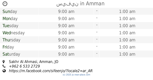
سيفين
Sakhr Al Ahmasi, Amman
Restaurant
read more
585 m
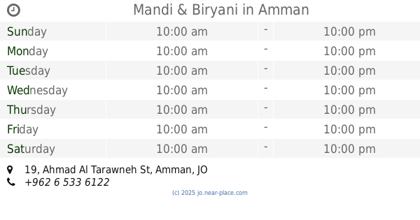
Mandi & Biryani
Saed Al Lawzi Complex, Ahmad Al Tarawneh St 19, Amman
Restaurant
read more
586 m
Ftima Abu Jbara
Yajouz Road, Amman
Restaurant
read more
592 m
Myriad Restaurant Aljbhe
Umm Khelad Street, Amman
Restaurant
read more
610 m
Little Caesars Pizza
Amman
Restaurant
read more
631 m
ملك الطاووق
Amman
Restaurant
read more
678 m
Ones Pizza & Lebanese Pastery
Amman
Restaurant
read more
682 m
Brothers Eatery
Al Rayyan, Amman
Restaurant
read more
688 m
Brothers Eatery
Yajouz Road 95, Amman
Restaurant
read more
704 m
Al Dayaa Restaurant
Adnan Al lozi Complex, Ahmad Al Tarawneh St 45, Amman
Restaurant
read more
771 m
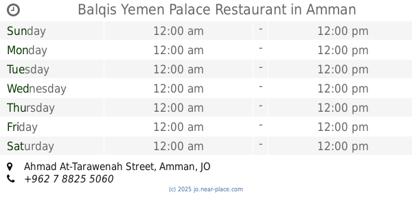
Balqis Yemen Palace Restaurant
Ahmad At-Tarawenah Street, Amman
Restaurant
read more
783 m
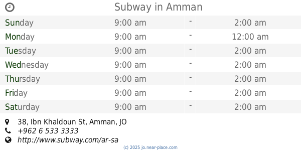
Subway
Plaza Al Khalidi Medical, Ibn Khaldoun St 38, Amman
Restaurant
read more
822 m
Noor Alshohaba
Amman
Restaurant
read more
840 m
مطعم بشوش
Amman
Restaurant
read more
846 m
مطعم العنيف الجبيهة
Ar-Rawaah Street, Amman
Restaurant
read more
880 m
Yazan abo leel
Rifaa Al-Ansari Street, Amman
Restaurant
read more
909 m
Lezzet Istanbul
Sakhr Al Ahmasi, Amman
Restaurant
read more
935 m
Mansouri fast food
Amman
Restaurant
read more
936 m
Mandi Palace Restaurant
Amman
Restaurant
read more
949 m
Hashtag Saj
Amman
Restaurant
read more
956 m
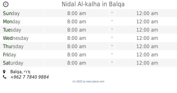
Nidal Al-kalha
Balqa
Restaurant
read more
1.016 km
القيصر الصغير
Gharrafah Al-Kendi Street, Amman
Restaurant
read more
📑
all categories
Accounting
Administrative area level 1
Administrative area level 2
Airport
Amusement park
Aquarium
Art gallery
Atm
Bakery
Bank
Bar
Beauty salon
Bicycle store
Book store
Bowling alley
Bus station
Cafe
Campground
Car dealer
Car rental
Car repair
Car wash
Cemetery
Church
City hall
Clothing store
Colloquial area
Convenience store
Country
Courthouse
Dentist
Department store
Doctor
Electrician
Electronics store
Embassy
Finance
Fire station
Florist
Food
Funeral home
Furniture store
Gas station
General contractor
Grocery or supermarket
Gym
Hair care
Hardware store
Health
Home goods store
Hospital
Insurance agency
Jewelry store
Laundry
Lawyer
Library
Liquor store
Local government office
Locality
Locksmith
Lodging
Meal delivery
Meal takeaway
Mosque
Movie rental
Movie theater
Moving company
Museum
Natural feature
Neighborhood
Night club
Painter
Park
Parking
Pet store
Pharmacy
Physiotherapist
Place of worship
Plumber
Point of interest
Police
Post office
Premise
Real estate agency
Restaurant
Route
Rv park, camping
School
Shoe store
Shopping mall
Spa
Stadium
Storage
Store
Supermarket
Taxi stand
Train station
Travel agency
University
Veterinary care
Zoo
sublocality level 1
↑