Restaurant nearby Abu Hardanh Resort
Jordan
Restaurant nearby Abu Hardanh Resort
Abu Hardanh Resort
Irbid Governorate, Иордания
contacts phone
:
+962
Latitude:
32.6543534
, Longitude:
35.6880516
larger map & directions
read more
nearest Restaurant
481 m
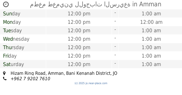
مطعم طعميني للوجبات السريعة
Jordan, Hizam Ring Road, Amman
Restaurant
read more
943 m
Umm Qais Rest House
Restaurant
read more
2.275 km
مطعم تايكي
Unnamed Rd,
Restaurant
read more
4.975 km
منتجع نهر الاردن
Restaurant
read more
5.006 km
استراحة ومسابح سرايا ابو ذياب
Restaurant
read more
5.58 km
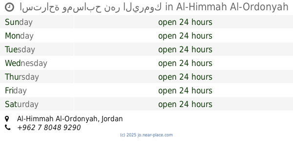
استراحة ومسابح نهر اليرموك
Al-Himmah Al-Ordonyah
Restaurant
read more
6.784 km
مطعم الراقي
Restaurant
read more
8.286 km
مطعم ومنتزه وكافيه ابو جفيل
Saham
Restaurant
read more
8.905 km
مطعم النشامى
Restaurant
read more
9.843 km
Falafil Taqli فلافل الطقلي
Qumaym
Restaurant
read more
10.165 km
Abu Imad Restaurant
Qumaym
Restaurant
read more
15.361 km
Petra Restaurant
Irbid
Restaurant
read more
16.631 km
مطعم ابوالعارف
Hizam Ring Road, Amman
Restaurant
read more
17.759 km
Restaurant & Grills Kababjee
Irbid
Restaurant
read more
17.766 km
مطعم حارتنا
Irbid
Restaurant
read more
18.099 km
Sea Waves Restaurant
Irbid
Restaurant
read more
18.478 km
FireFly Burgers
Al Thaqafeh Street, Irbid
Restaurant
read more
18.573 km
شاورما النغش
10, Irbid
Restaurant
read more
19.092 km
مطعم عبوده 2
غرب دوار مول ب200م, Irbid
Restaurant
read more
19.212 km
Sweets Awabh Homs
مول, Irbid
Restaurant
read more
19.281 km
مطعم لنا ميزه
Ar-Razi Street, Irbid
Restaurant
read more
19.321 km
Crispy Restaurant
Irbid
Restaurant
read more
19.841 km
Dia'a Al Rabeah Restaurant
Irbid
Restaurant
read more
20.162 km
ملحمة و مشاوي ضاحية الحسين
Pr. Mohammed St., Irbid
Restaurant
read more
20.679 km
Bird Restaurant
Prince Muhammad Street, Irbid
Restaurant
read more
📑
all categories
Accounting
Administrative area level 1
Administrative area level 2
Airport
Amusement park
Aquarium
Art gallery
Atm
Bakery
Bank
Bar
Beauty salon
Bicycle store
Book store
Bowling alley
Bus station
Cafe
Campground
Car dealer
Car rental
Car repair
Car wash
Cemetery
Church
City hall
Clothing store
Colloquial area
Convenience store
Country
Courthouse
Dentist
Department store
Doctor
Electrician
Electronics store
Embassy
Finance
Fire station
Florist
Food
Funeral home
Furniture store
Gas station
General contractor
Grocery or supermarket
Gym
Hair care
Hardware store
Health
Home goods store
Hospital
Insurance agency
Jewelry store
Laundry
Lawyer
Library
Liquor store
Local government office
Locality
Locksmith
Lodging
Meal delivery
Meal takeaway
Mosque
Movie rental
Movie theater
Moving company
Museum
Natural feature
Neighborhood
Night club
Painter
Park
Parking
Pet store
Pharmacy
Physiotherapist
Place of worship
Plumber
Point of interest
Police
Post office
Premise
Real estate agency
Restaurant
Route
Rv park, camping
School
Shoe store
Shopping mall
Spa
Stadium
Storage
Store
Supermarket
Taxi stand
Train station
Travel agency
University
Veterinary care
Zoo
sublocality level 1
↑