Point of interest nearby جمعية حيان الرويبض
Jordan
Point of interest nearby جمعية حيان الرويبض
جمعية حيان الرويبض
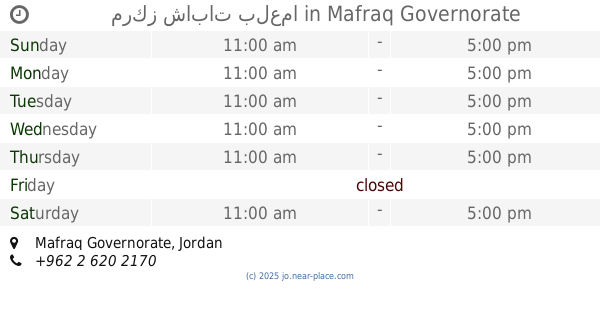
Mafraq Governorate, Jordan
contacts phone
:
+962
Latitude:
32.2417749
, Longitude:
36.1305192
larger map & directions
read more
nearest Point of interest
525 m
Hayyan Rwaibed Knowledge Station
Balama
Point of interest
read more
3.191 km
مدرسة الجبل الاخضر
Point of interest
read more
3.259 km
Jordan Mafraq Balaama Green Mountain
Point of interest
read more
3.792 km
بلدية بلعما الجديدة
Point of interest
read more
3.916 km
مركز شابات بلعما
Point of interest
read more
3.921 km
محكمة بلعما
Point of interest
read more
3.959 km
Bala'ma Knowledge Station
25, Balama
Point of interest
read more
3.985 km
دائرة الاحوال المدنية والجوازات
قضاء بلعما
Point of interest
read more
4.434 km
مزرعة جميل ردايدة
بلعما حيان المشرف, Al-Mafraq
Point of interest
read more
4.447 km
مركز دفاع مدني بلعما
Point of interest
read more
4.451 km
Farm Abu Walid Al-Shalabi
Al Zaytonah, Amman
Point of interest
read more
4.566 km
ملعب بلعما البلدي
Point of interest
read more
5.501 km
محطة معرفة الزنية
Znaya
Point of interest
read more
5.507 km
جمعية الزنية
Point of interest
read more
5.609 km
جمعيه ظلال الرحمه الخيريه
المفرق/الزنيه.حي، المدارس، الزنية،
Point of interest
read more
11.329 km
Alhashimiah Ladies community based organization
Point of interest
read more
12.06 km
نزار المشاقبة للخلويات
Point of interest
read more
12.717 km
Al-Mafraq Commerce and Industry Chambre
Al-Mafraq
Point of interest
read more
13.192 km
مؤسسة أمنيه للديكورات
Al-Mafraq
Point of interest
read more
13.344 km
TOYOTA Dealer
Al-Mafraq
Point of interest
read more
13.603 km
Hussein Thermal Station
King Talal Street
Point of interest
read more
13.692 km
التل الاثري
As-Sukhnah
Point of interest
read more
14.538 km
Faculty of Law
Al-Mafraq
Point of interest
read more
14.56 km
كلية الهندسة
Al, Al-Mafraq
Point of interest
read more
14.89 km
جمعية المنشية للتربية الخاصة
Unnamed Road, Al-Manshiyah
Point of interest
read more
📑
all categories
Accounting
Administrative area level 1
Administrative area level 2
Airport
Amusement park
Aquarium
Art gallery
Atm
Bakery
Bank
Bar
Beauty salon
Bicycle store
Book store
Bowling alley
Bus station
Cafe
Campground
Car dealer
Car rental
Car repair
Car wash
Cemetery
Church
City hall
Clothing store
Colloquial area
Convenience store
Country
Courthouse
Dentist
Department store
Doctor
Electrician
Electronics store
Embassy
Finance
Fire station
Florist
Food
Funeral home
Furniture store
Gas station
General contractor
Grocery or supermarket
Gym
Hair care
Hardware store
Health
Home goods store
Hospital
Insurance agency
Jewelry store
Laundry
Lawyer
Library
Liquor store
Local government office
Locality
Locksmith
Lodging
Meal delivery
Meal takeaway
Mosque
Movie rental
Movie theater
Moving company
Museum
Natural feature
Neighborhood
Night club
Painter
Park
Parking
Pet store
Pharmacy
Physiotherapist
Place of worship
Plumber
Point of interest
Police
Post office
Premise
Real estate agency
Restaurant
Route
Rv park, camping
School
Shoe store
Shopping mall
Spa
Stadium
Storage
Store
Supermarket
Taxi stand
Train station
Travel agency
University
Veterinary care
Zoo
sublocality level 1
↑