Point of interest nearby Hamoda Link
Jordan
Point of interest nearby Hamoda Link
Hamoda Link
Madinat Al-Sharq, Az-Zarqa, Иордания
contacts phone
:
+962
Latitude:
32.0861087
, Longitude:
36.0892356
larger map & directions
read more
nearest Point of interest
148 m
منجرة الشراع
Az-Zarqa
Point of interest
read more
198 m
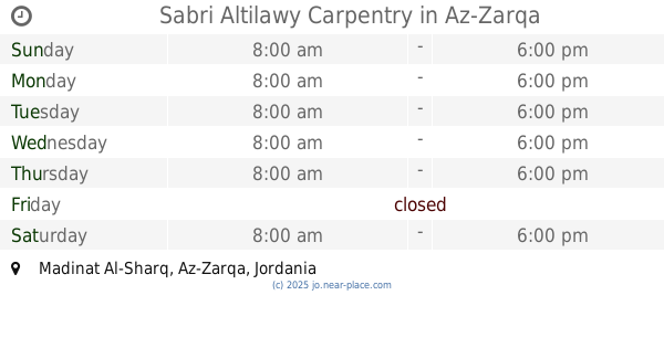
Sabri Altilawy Carpentry
Az-Zarqa
Point of interest
read more
199 m
مؤسسة العيساوي التجارية
Az-Zarqa
Point of interest
read more
232 m
منجرة العاشوري
Az-Zarqa
Point of interest
read more
238 m
Carmen Internet
Az-Zarqa
Point of interest
read more
264 m
عالم اللوكسار
Az-Zarqa
Point of interest
read more
303 m
Thamir Issawi company Blacksmith & Aluminium
الزرقاء الزرقاء الجديدة شارع 36 الحرفين بجانب السيفوي, Az-Zarqa
Point of interest
read more
397 m
علاء المصري للعدد الصناعية
Az-Zarqa
Point of interest
read more
435 m
Development and Employment Fund
Az-Zarqa
Point of interest
read more
473 m
مسبح المهندس
Az-Zarqa
Point of interest
read more
481 m
STORM-36 PC GAMING
Az-Zarqa
Point of interest
read more
510 m
الرباط للدعاية والتسويق
Mecca Street, Az-Zarqa
Point of interest
read more
596 m
أكاديمية ايليت للمحادثة و التدريب
Mecca Street, Az-Zarqa
Point of interest
read more
601 m
Nasser Center
Az-Zarqa
Point of interest
read more
605 m
مركز عاصم الكوفي
Az-Zarqa
Point of interest
read more
634 m
Karam Zitawi Mobiles
Az-Zarqa
Point of interest
read more
697 m
Right To Play International Zarqa Office
Mecca Street, Az-Zarqa
Point of interest
read more
731 m
مركز أمن البتراوي
Az-Zarqa
Point of interest
read more
812 m
Coffee Abu night
Army Street, Az-Zarqa
Point of interest
read more
857 m
المتميز لمواد البناء
Az-Zarqa
Point of interest
read more
929 m
Zeitoun Center
Az-Zarqa
Point of interest
read more
981 m
مركز جمعية رعايةاسرة الجندي
Az-Zarqa
Point of interest
read more
1.049 km
الرعد للخلويات
Army Street, Az-Zarqa
Point of interest
read more
1.054 km
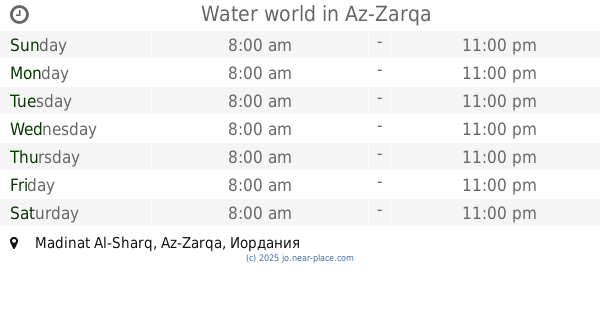
Water world
Az-Zarqa
Point of interest
read more
1.063 km
مخيطة بيت المقدس
Az-Zarqa
Point of interest
read more
📑
all categories
Accounting
Administrative area level 1
Administrative area level 2
Airport
Amusement park
Aquarium
Art gallery
Atm
Bakery
Bank
Bar
Beauty salon
Bicycle store
Book store
Bowling alley
Bus station
Cafe
Campground
Car dealer
Car rental
Car repair
Car wash
Cemetery
Church
City hall
Clothing store
Colloquial area
Convenience store
Country
Courthouse
Dentist
Department store
Doctor
Electrician
Electronics store
Embassy
Finance
Fire station
Florist
Food
Funeral home
Furniture store
Gas station
General contractor
Grocery or supermarket
Gym
Hair care
Hardware store
Health
Home goods store
Hospital
Insurance agency
Jewelry store
Laundry
Lawyer
Library
Liquor store
Local government office
Locality
Locksmith
Lodging
Meal delivery
Meal takeaway
Mosque
Movie rental
Movie theater
Moving company
Museum
Natural feature
Neighborhood
Night club
Painter
Park
Parking
Pet store
Pharmacy
Physiotherapist
Place of worship
Plumber
Point of interest
Police
Post office
Premise
Real estate agency
Restaurant
Route
Rv park, camping
School
Shoe store
Shopping mall
Spa
Stadium
Storage
Store
Supermarket
Taxi stand
Train station
Travel agency
University
Veterinary care
Zoo
sublocality level 1
↑