Point of interest nearby النور لبطاقات الأفراح والمطبوعات
Jordan
Point of interest nearby النور لبطاقات الأفراح والمطبوعات
النور لبطاقات الأفراح والمطبوعات
شارع عمر بن الخطاب،, Az-Zarqa Израиль
contacts phone
:
+962
Latitude:
32.0733761
, Longitude:
36.097012
read more
nearest Point of interest
225 m
مؤسسة الطحاينة التموينية
Az-Zarqa
Point of interest
read more
277 m
اوسكار للكمبيوتر
Az-Zarqa
Point of interest
read more
309 m
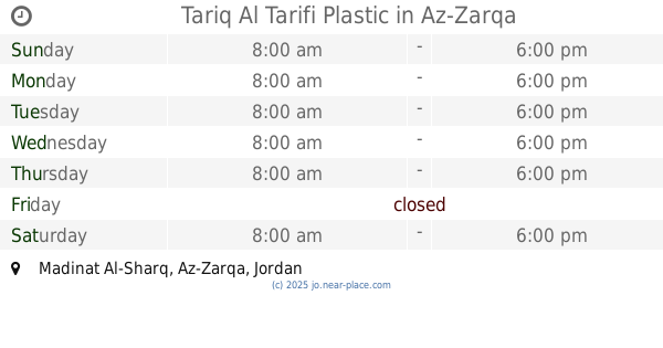
Tariq Al Tarifi Plastic
Az-Zarqa
Point of interest
read more
349 m
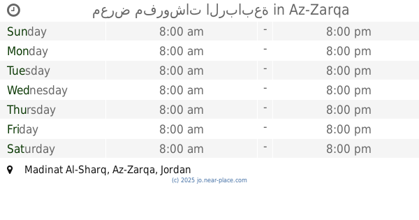
معرض مفروشات الربابعة
Az-Zarqa
Point of interest
read more
425 m
Miyahuna مياهنا
Az-Zarqa
Point of interest
read more
457 m
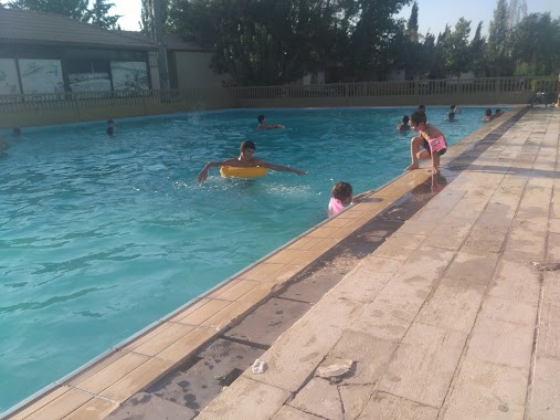
مسبح العائلة
Army Street, Az-Zarqa
Point of interest
read more
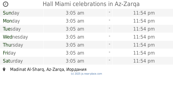
472 m
Hall Miami celebrations
Az-Zarqa
Point of interest
read more
536 m
غرفة تجارة الزرقاء
30, Az-Zarqa
Point of interest
read more
582 m
Dewan AL SHAMMAS
شارع الأندلس،, Az-Zarqa
Point of interest
read more
607 m
البتراء لزينة السيارات
Az-Zarqa
Point of interest
read more
666 m
مركز السابم لخدمة السيارات
الزرقاء, شارع الأمير زيد, رعد
Point of interest
read more
725 m
مركز جمعية رعايةاسرة الجندي
Az-Zarqa
Point of interest
read more
767 m
روعة الهاتف
Army Street, Az-Zarqa
Point of interest
read more
777 m
كافتيريا الامل
Army Street, Az-Zarqa
Point of interest
read more
826 m
جمعية نشميات الجنوب الخيرية
شارع الفاروق
Point of interest
read more
890 m
الرعد للخلويات
Army Street, Az-Zarqa
Point of interest
read more
965 m
Karam Zitawi Mobiles
Az-Zarqa
Point of interest
read more
971 m
مركز مؤاب الثقافي MCC
Az-Zarqa
Point of interest
read more
983 m
Coffee Abu night
Army Street, Az-Zarqa
Point of interest
read more
994 m
Office of the clans of Bani Sakhr
Az-Zarqa
Point of interest
read more
997 m
غاز جنى
Az-Zarqa
Point of interest
read more
1.004 km
النقابة العامة للعاملين بالبترول والكيماويات الأردنية
شارع بغداد،، الزرقاء
Point of interest
read more
1.012 km
Munib Water
Az-Zarqa
Point of interest
read more
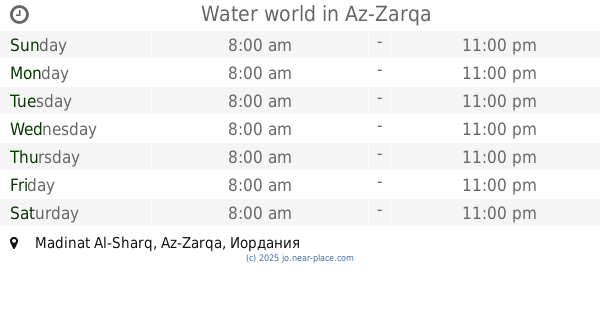
1.017 km
Water world
Az-Zarqa
Point of interest
read more
1.158 km
جمعية عقربا الخيرية
Az-Zarqa
Point of interest
read more
📑
all categories
Accounting
Administrative area level 1
Administrative area level 2
Airport
Amusement park
Aquarium
Art gallery
Atm
Bakery
Bank
Bar
Beauty salon
Bicycle store
Book store
Bowling alley
Bus station
Cafe
Campground
Car dealer
Car rental
Car repair
Car wash
Cemetery
Church
City hall
Clothing store
Colloquial area
Convenience store
Country
Courthouse
Dentist
Department store
Doctor
Electrician
Electronics store
Embassy
Finance
Fire station
Florist
Food
Funeral home
Furniture store
Gas station
General contractor
Grocery or supermarket
Gym
Hair care
Hardware store
Health
Home goods store
Hospital
Insurance agency
Jewelry store
Laundry
Lawyer
Library
Liquor store
Local government office
Locality
Locksmith
Lodging
Meal delivery
Meal takeaway
Mosque
Movie rental
Movie theater
Moving company
Museum
Natural feature
Neighborhood
Night club
Painter
Park
Parking
Pet store
Pharmacy
Physiotherapist
Place of worship
Plumber
Point of interest
Police
Post office
Premise
Real estate agency
Restaurant
Route
Rv park, camping
School
Shoe store
Shopping mall
Spa
Stadium
Storage
Store
Supermarket
Taxi stand
Train station
Travel agency
University
Veterinary care
Zoo
sublocality level 1
↑