Pharmacy nearby صيدلية الابرار
Jordan
Pharmacy nearby صيدلية الابرار
صيدلية الابرار
Al-Baladeyah Street, Irbid, Hosha Sub-District, JO Jordan
contacts phone
:
+962
Latitude:
32.4384891
, Longitude:
36.1483368
larger map & directions
read more
nearest Pharmacy
4.927 km
Ronza Pharmacy
Pharmacy
read more
5.079 km
Changer Al Sarhan Pharmacy
Pharmacy
read more
5.547 km
صيدلية اكاسيا
Pharmacy
read more
9.878 km
El Mansheya Pharmacy
Al Baladiyah, Amman
Pharmacy
read more
11.317 km
Ronas Pharmacy
Mutah Street, Al-Mafraq
Pharmacy
read more
11.322 km
((Ronas Pharmacy)) Hay Al-Hussein
Mutah Street, Al-Mafraq
Pharmacy
read more
11.809 km
صيدلية نوران
Al-Mafraq
Pharmacy
read more
11.827 km
Pharmacy Shwaika
Al-Mafraq
Pharmacy
read more
11.878 km
Shobaki Pharmacy Zahira
Al-Mafraq
Pharmacy
read more
11.978 km
صيدلية الزعبي
Al-Mafraq
Pharmacy
read more
11.979 km
صيدلية شواقفة
Hisham Bin Abdulmalik Street, Al-Mafraq
Pharmacy
read more
12.125 km
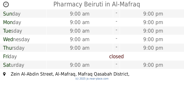
Pharmacy Beiruti
Zein Al-Abdin Street, Al-Mafraq
Pharmacy
read more
12.339 km
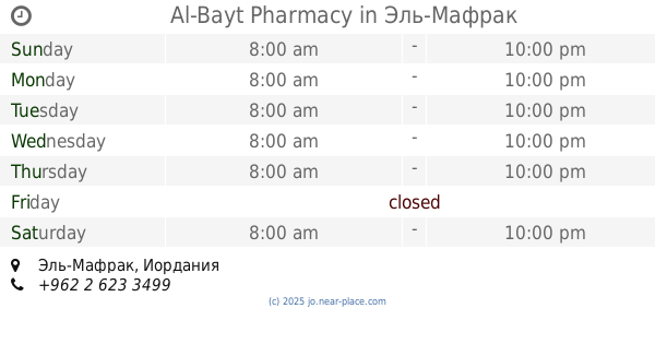
Al-Bayt Pharmacy
Al-Mafraq
Pharmacy
read more
12.4 km
صيدلية مؤمن بالله
20, Al-Mafraq
Pharmacy
read more
12.625 km
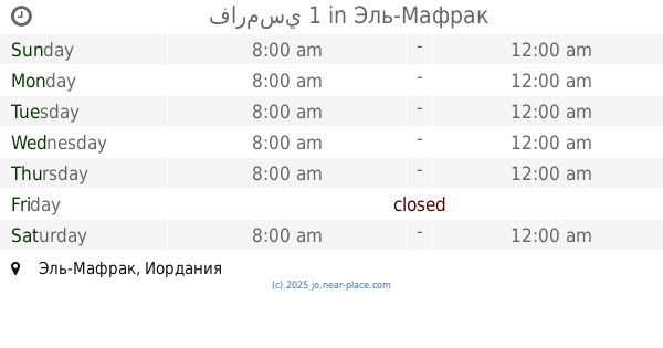
فارمسي 1
Al-Mafraq
Pharmacy
read more
12.636 km
Amassi Pharmacy
Al-Mafraq
Pharmacy
read more
12.929 km
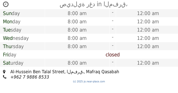
صيدلية رغد
Al-Hussein Ben Talal Street, المفرق،
Pharmacy
read more
13.723 km
صيدلية بكر الخزاعلة
المفرق، رحاب،
Pharmacy
read more
17.264 km
صيدلية تقارب
Ramtha
Pharmacy
read more
17.514 km
Wed Pharmacy صيدلية ود
Unnamed Road،, Ramtha
Pharmacy
read more
18.384 km
Marina Pharmacy
King Talal Street, Ramtha
Pharmacy
read more
18.853 km
صيدلية بوفارديا
الرمثا ، محافظة, اربد، الاردن
Pharmacy
read more
18.863 km
صيدلية حسام الجديدة
Al-Mutanabbi Street, Ramtha
Pharmacy
read more
19.303 km
Tulip pharmacy
king abdallah ramtha 11965
Pharmacy
read more
19.664 km
Lucy Pharmacy
Pharmacy
read more
📑
all categories
Accounting
Administrative area level 1
Administrative area level 2
Airport
Amusement park
Aquarium
Art gallery
Atm
Bakery
Bank
Bar
Beauty salon
Bicycle store
Book store
Bowling alley
Bus station
Cafe
Campground
Car dealer
Car rental
Car repair
Car wash
Cemetery
Church
City hall
Clothing store
Colloquial area
Convenience store
Country
Courthouse
Dentist
Department store
Doctor
Electrician
Electronics store
Embassy
Finance
Fire station
Florist
Food
Funeral home
Furniture store
Gas station
General contractor
Grocery or supermarket
Gym
Hair care
Hardware store
Health
Home goods store
Hospital
Insurance agency
Jewelry store
Laundry
Lawyer
Library
Liquor store
Local government office
Locality
Locksmith
Lodging
Meal delivery
Meal takeaway
Mosque
Movie rental
Movie theater
Moving company
Museum
Natural feature
Neighborhood
Night club
Painter
Park
Parking
Pet store
Pharmacy
Physiotherapist
Place of worship
Plumber
Point of interest
Police
Post office
Premise
Real estate agency
Restaurant
Route
Rv park, camping
School
Shoe store
Shopping mall
Spa
Stadium
Storage
Store
Supermarket
Taxi stand
Train station
Travel agency
University
Veterinary care
Zoo
sublocality level 1
↑