Pharmacy nearby صيدليه ربوع الاردن
Jordan
Pharmacy nearby صيدليه ربوع الاردن
صيدليه ربوع الاردن
سحاب_دوارالشهيد،، Amman, Иордания
contacts phone
:
+962 7 7752 1721
Latitude:
31.8694049
, Longitude:
36.006289
larger map & directions
read more
nearest Pharmacy
39 m
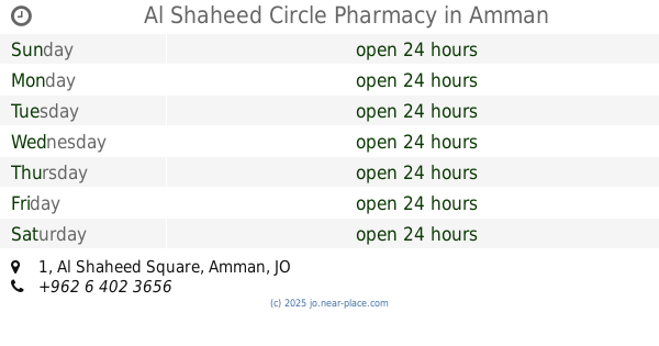
Al Shaheed Circle Pharmacy
Complex No 1, Al Shaheed Square 1, Amman
Pharmacy
read more
106 m
Badia Veterinary Pharmacy
Al-Shuhada Circle, Amman
Pharmacy
read more
117 m
صيدلية شروق الامل
ش. سحاب،, Amman
Pharmacy
read more
257 m
صيدلية البادية
Amman
Pharmacy
read more
312 m
Mujama' sahab aljadeed pharmacy
Sahab Street, Amman
Pharmacy
read more
478 m
صيدلية سلبود
Hizam Ring Road, Amman
Pharmacy
read more
710 m
صيدلية جنوب عمان
Unnamed Road, Amman
Pharmacy
read more
748 m
الحديثة لصناعة الادوية البيطرية
Amman
Pharmacy
read more
1.491 km
Salmoneh Pharmacy
Complex No 133, Sahab St 133, Amman
Pharmacy
read more
1.555 km
صيدلية البيت العتيق
منطقة أحد، عمّان،
Pharmacy
read more
1.637 km
Alfareed Pharmacy
Amman
Pharmacy
read more
1.754 km
Shwaikeh Chemicals Ist.
40, Amman
Pharmacy
read more
1.792 km
صيدلية الدر المنثور
Amman
Pharmacy
read more
2 km
لافندر
Hizam Ring Road, Amman
Pharmacy
read more
2 km
لافندر جل الغسيل
Amman
Pharmacy
read more
2.025 km
صيدلية نبع زمزم
Hizam Ring Road, Amman
Pharmacy
read more
3.391 km
Cocamela Manufacturing
Unnamed Rd, Jordan
Pharmacy
read more
3.401 km
صيدليه الاقحوان
Unnamed, Al Hezam Road, Amman
Pharmacy
read more
3.916 km
صيدليه الودق
ش. زياد بن كعب،، عمّان
Pharmacy
read more
4.959 km
صيدلية اليمامة
النقيرة،, Amman
Pharmacy
read more
5.429 km
Pharmacy polyestrous صيدلية الودق
Amman
Pharmacy
read more
5.542 km
Abu Alanda Pharmacy
Ali Zidan Al Huneiti Complex, Ahl Al Kahf St 3, Amman
Pharmacy
read more
5.634 km
Al Midan Pharmacy
Complex No 26, Ali Al Doukhi Al Huneiti St 26, Amman
Pharmacy
read more
11.87 km
صيدلية القوة ، شارع الحرية Power Pharma
Amman
Pharmacy
read more
18.335 km
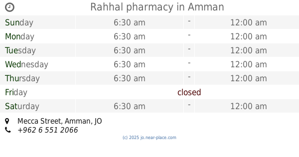
Rahhal pharmacy
Mecca Street, Amman
Pharmacy
read more
📑
all categories
Accounting
Administrative area level 1
Administrative area level 2
Airport
Amusement park
Aquarium
Art gallery
Atm
Bakery
Bank
Bar
Beauty salon
Bicycle store
Book store
Bowling alley
Bus station
Cafe
Campground
Car dealer
Car rental
Car repair
Car wash
Cemetery
Church
City hall
Clothing store
Colloquial area
Convenience store
Country
Courthouse
Dentist
Department store
Doctor
Electrician
Electronics store
Embassy
Finance
Fire station
Florist
Food
Funeral home
Furniture store
Gas station
General contractor
Grocery or supermarket
Gym
Hair care
Hardware store
Health
Home goods store
Hospital
Insurance agency
Jewelry store
Laundry
Lawyer
Library
Liquor store
Local government office
Locality
Locksmith
Lodging
Meal delivery
Meal takeaway
Mosque
Movie rental
Movie theater
Moving company
Museum
Natural feature
Neighborhood
Night club
Painter
Park
Parking
Pet store
Pharmacy
Physiotherapist
Place of worship
Plumber
Point of interest
Police
Post office
Premise
Real estate agency
Restaurant
Route
Rv park, camping
School
Shoe store
Shopping mall
Spa
Stadium
Storage
Store
Supermarket
Taxi stand
Train station
Travel agency
University
Veterinary care
Zoo
sublocality level 1
↑