Pharmacy nearby Pharmacy Pharmacy world
Jordan
Pharmacy nearby Pharmacy Pharmacy world
Pharmacy Pharmacy world
Kherbat as-Souk, Amman, Jordan
contacts phone
:
+962
website:
www.pharmacyworld-jo.com
Latitude:
31.864482
, Longitude:
35.9270532
larger map & directions
read more
nearest Pharmacy
299 m
ص عاليه
عمان جارا
Pharmacy
read more
651 m
صيدلية يامن
Amman
Pharmacy
read more
651 m
Pharmacy Nemati
Amman
Pharmacy
read more
674 m
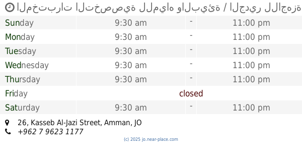
المختبرات التخصصية للمياه والبيئة / الجدير للاجهزة العلمية والطبية
Kasseb Al-Jazi Street 26, Amman
Pharmacy
read more
708 m
صيدلية نغم
Amman
Pharmacy
read more
709 m
ازهار المائن
Amman
Pharmacy
read more
834 m
Ehab Pharmacy
Amman
Pharmacy
read more
1.246 km
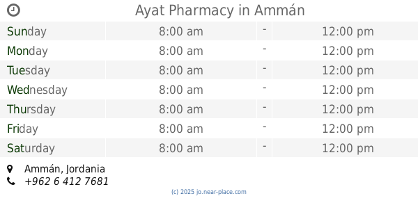
Ayat Pharmacy
Amman
Pharmacy
read more
1.283 km
Shadia Pharmacy
Complex No 254, Madaba St 254, Amman
Pharmacy
read more
1.39 km
الغصن الأخضر
Kab Ibn Amr, Amman
Pharmacy
read more
1.584 km
Al Yadoodeh Pharmacy
Rmada Center, Madaba St 268, Amman
Pharmacy
read more
1.703 km
صيدلية نيازي
شارع جاوا،، عمّان
Pharmacy
read more
1.798 km
Al Sabah Pharmacy
Complex No 6, Aisha Bint Talhah St 6, Amman
Pharmacy
read more
1.865 km
صدلية أوراق العنَّاب
Amman
Pharmacy
read more
1.867 km
Pharmacy Jujube
Salamah Al-Bloush Street, Amman
Pharmacy
read more
1.978 km
Pharmacy Aserat
Amman
Pharmacy
read more
1.989 km
صيدلية فارمسي
الجويدة،, Amman
Pharmacy
read more
2.174 km
Mercury Pharmacy
Amman
Pharmacy
read more
2.223 km
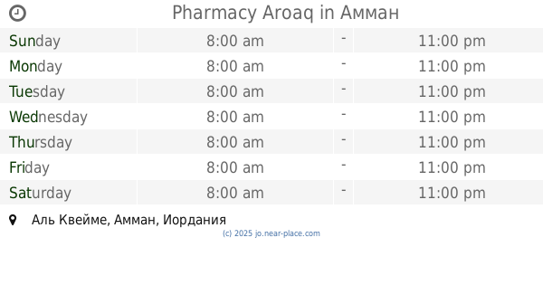
Pharmacy Aroaq
Amman
Pharmacy
read more
2.232 km
ZEBAQ PHARMACY
Amman
Pharmacy
read more
2.661 km
Eskan Al Sayadela Pharmacy
Da'san Commercial Complex, Madaba St 325, Amman
Pharmacy
read more
2.741 km
Riemann Pharmacy
Amman
Pharmacy
read more
3.043 km
صيدلية ام قصير , المقابلين
31.8880260, 35.9106150
Pharmacy
read more
4.352 km
Ahmed Store For Vet.Drugs
شارع مادبا،، عمّان
Pharmacy
read more
5.836 km
صيدلية القوة ، شارع الحرية Power Pharma
Amman
Pharmacy
read more
📑
all categories
Accounting
Administrative area level 1
Administrative area level 2
Airport
Amusement park
Aquarium
Art gallery
Atm
Bakery
Bank
Bar
Beauty salon
Bicycle store
Book store
Bowling alley
Bus station
Cafe
Campground
Car dealer
Car rental
Car repair
Car wash
Cemetery
Church
City hall
Clothing store
Colloquial area
Convenience store
Country
Courthouse
Dentist
Department store
Doctor
Electrician
Electronics store
Embassy
Finance
Fire station
Florist
Food
Funeral home
Furniture store
Gas station
General contractor
Grocery or supermarket
Gym
Hair care
Hardware store
Health
Home goods store
Hospital
Insurance agency
Jewelry store
Laundry
Lawyer
Library
Liquor store
Local government office
Locality
Locksmith
Lodging
Meal delivery
Meal takeaway
Mosque
Movie rental
Movie theater
Moving company
Museum
Natural feature
Neighborhood
Night club
Painter
Park
Parking
Pet store
Pharmacy
Physiotherapist
Place of worship
Plumber
Point of interest
Police
Post office
Premise
Real estate agency
Restaurant
Route
Rv park, camping
School
Shoe store
Shopping mall
Spa
Stadium
Storage
Store
Supermarket
Taxi stand
Train station
Travel agency
University
Veterinary care
Zoo
sublocality level 1
↑