Pharmacy nearby Al Aasef Pharmacy
Jordan
Pharmacy nearby Al Aasef Pharmacy
Al Aasef Pharmacy
Мадаба, Иордания
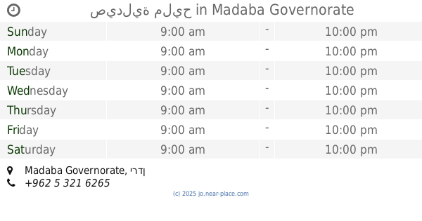
contacts phone
:
+962
Latitude:
31.7202154
, Longitude:
35.7929343
larger map & directions
read more
nearest Pharmacy
141 m
Jarir Pharmacy
King Hussein Street, Madaba
Pharmacy
read more
538 m
Hadaqa Drug Store
ش. خالد بن الوليد،، مأدبا
Pharmacy
read more
668 m
صيدلية تبارك
Madaba
Pharmacy
read more
718 m
صيدلية سما مادبا
Maadaba Al-Gharbi Street, Madaba
Pharmacy
read more
737 m
صيدلية بغداد
Madaba
Pharmacy
read more
775 m
صيدلية سناء
Madaba
Pharmacy
read more
833 m
صيدلية الفلاح
Madaba
Pharmacy
read more
912 m
صيدلية ابن كثير
Madaba
Pharmacy
read more
955 m
صيدلية الرفاه
الحمد،, Madaba
Pharmacy
read more
956 m
صيدلية المداواه
الشفاء،, Madaba
Pharmacy
read more
1.033 km
Awni Pharmacy
Madaba
Pharmacy
read more
1.177 km
صيدلية البهجة Alpahja Pharmacy
Omar Ben Al-Khattab Street, Madaba
Pharmacy
read more
1.309 km
2 Pharmacy
Ibn Kathir Street, Madaba
Pharmacy
read more
12.505 km
صيدلية أسامة وزينة
ش. مأدبا الغربي،, Amman
Pharmacy
read more
14.966 km
صيدلية مليح
Pharmacy
read more
16.381 km
Ahmed Store For Vet.Drugs
شارع مادبا،، عمّان
Pharmacy
read more
16.408 km
Pharmacy 1
Jamal Plaza Gas Station, Queen Alia Airport St 568, Amman
Pharmacy
read more
16.934 km
Pharmacy Gulls Veterinary
Madaba Highway, Amman
Pharmacy
read more
17.893 km
Eskan Al Sayadela Pharmacy
Da'san Commercial Complex, Madaba St 325, Amman
Pharmacy
read more
18.278 km
ZEBAQ PHARMACY
Amman
Pharmacy
read more
18.339 km
Mercury Pharmacy
Amman
Pharmacy
read more
18.53 km
Pharmacy Aserat
Amman
Pharmacy
read more
18.663 km
Al Sabah Pharmacy
Complex No 6, Aisha Bint Talhah St 6, Amman
Pharmacy
read more
18.91 km
Al Yadoodeh Pharmacy
Rmada Center, Madaba St 268, Amman
Pharmacy
read more
20.097 km
صيدلية نيازي
شارع جاوا،، عمّان
Pharmacy
read more
📑
all categories
Accounting
Administrative area level 1
Administrative area level 2
Airport
Amusement park
Aquarium
Art gallery
Atm
Bakery
Bank
Bar
Beauty salon
Bicycle store
Book store
Bowling alley
Bus station
Cafe
Campground
Car dealer
Car rental
Car repair
Car wash
Cemetery
Church
City hall
Clothing store
Colloquial area
Convenience store
Country
Courthouse
Dentist
Department store
Doctor
Electrician
Electronics store
Embassy
Finance
Fire station
Florist
Food
Funeral home
Furniture store
Gas station
General contractor
Grocery or supermarket
Gym
Hair care
Hardware store
Health
Home goods store
Hospital
Insurance agency
Jewelry store
Laundry
Lawyer
Library
Liquor store
Local government office
Locality
Locksmith
Lodging
Meal delivery
Meal takeaway
Mosque
Movie rental
Movie theater
Moving company
Museum
Natural feature
Neighborhood
Night club
Painter
Park
Parking
Pet store
Pharmacy
Physiotherapist
Place of worship
Plumber
Point of interest
Police
Post office
Premise
Real estate agency
Restaurant
Route
Rv park, camping
School
Shoe store
Shopping mall
Spa
Stadium
Storage
Store
Supermarket
Taxi stand
Train station
Travel agency
University
Veterinary care
Zoo
sublocality level 1
↑