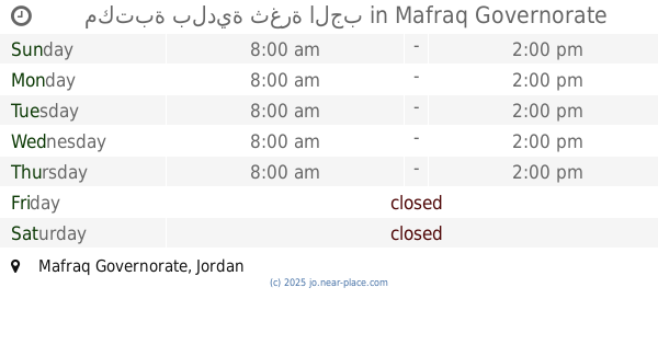
Library nearby مكتبة بلدية منشية بني حسن
Jordan
Library nearby مكتبة بلدية منشية بني حسن
مكتبة بلدية منشية بني حسن
Эль-Мафрак, Иордания
contacts phone
:
+962 7 7687 6456
Latitude:
32.3699262
, Longitude:
36.0852445
larger map & directions
read more
nearest Library
11.754 km
Municipal Library
Al-Mafraq
Library
read more
11.956 km
مكتبة شقير المفرق
King Talal Street, Al-Mafraq
Library
read more
12.39 km
مكتبة الجامعة
Al-Mafraq
Library
read more
12.401 km
مكتبة العربي
Al-Mafraq
Library
read more
12.422 km
Quraish library
الاردن المفرق المجمع الشرقي شارع الشهيد فرحان, Al-Mafraq
Library
read more
14.944 km
البيالي للخدمات العامه
الاردن، المفرق مغير السرحان، المفرق
Library
read more
15.028 km
المكتبة الهاشمية
Al-Albayt University
Library
read more
16.415 km
JUST Library
Ramtha
Library
read more
16.433 km
JUST university Library
Ramtha
Library
read more
16.439 km
مكتبة جامعة العلوم و التكنولوجيا الاردنية JUST Library
Ramtha
Library
read more
17.169 km
مكتبة بلدية ثغرة الجب
Library
read more
20.493 km
المكتبة الأسلامية
شارع الشعب, Jerash
Library
read more
22.588 km
Rassam Library
Ramtha
Library
read more
24.21 km
المكتبة العلمية
166, Jerash
Library
read more
27.195 km
Do Art
Unnamed Road
Library
read more
27.938 km
Alqousor
Irbid
Library
read more
28.258 km
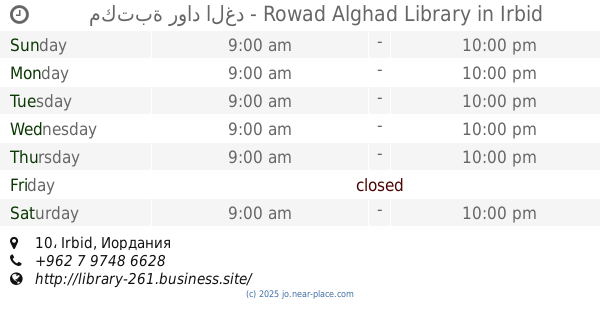
مكتبة رواد الغد - Rowad Alghad Library
10, Irbid
Library
read more
28.625 km
مكتبة قرطاسية البلقاء
مقابل كلية بنات, Irbid
Library
read more
28.971 km
Alwan Library
Ar-Razi Street, Irbid
Library
read more
29.6 km
مكتبة التميز
Zaki At-Tall Street, Irbid
Library
read more
29.602 km
Friends Bookstore
Al-Imam Malek Street, Irbid
Library
read more
29.663 km
مكتبة شاهين
Library
read more
30.045 km
مكتبة يثرب Yathrb Library
Irbid
Library
read more
30.183 km
مكتبة بلال _Bilal Library
حي الهاشمي،, Irbid
Library
read more
30.782 km
Hanina Library
Irbid
Library
read more
📑
all categories
Accounting
Administrative area level 1
Administrative area level 2
Airport
Amusement park
Aquarium
Art gallery
Atm
Bakery
Bank
Bar
Beauty salon
Bicycle store
Book store
Bowling alley
Bus station
Cafe
Campground
Car dealer
Car rental
Car repair
Car wash
Cemetery
Church
City hall
Clothing store
Colloquial area
Convenience store
Country
Courthouse
Dentist
Department store
Doctor
Electrician
Electronics store
Embassy
Finance
Fire station
Florist
Food
Funeral home
Furniture store
Gas station
General contractor
Grocery or supermarket
Gym
Hair care
Hardware store
Health
Home goods store
Hospital
Insurance agency
Jewelry store
Laundry
Lawyer
Library
Liquor store
Local government office
Locality
Locksmith
Lodging
Meal delivery
Meal takeaway
Mosque
Movie rental
Movie theater
Moving company
Museum
Natural feature
Neighborhood
Night club
Painter
Park
Parking
Pet store
Pharmacy
Physiotherapist
Place of worship
Plumber
Point of interest
Police
Post office
Premise
Real estate agency
Restaurant
Route
Rv park, camping
School
Shoe store
Shopping mall
Spa
Stadium
Storage
Store
Supermarket
Taxi stand
Train station
Travel agency
University
Veterinary care
Zoo
sublocality level 1
↑