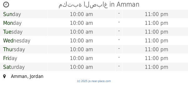
Library nearby مكتبة العوسج
Jordan
Library nearby مكتبة العوسج
مكتبة العوسج
منطقة مرج الحمام،, Amman Israel
contacts phone
:
+962
Latitude:
31.9028628
, Longitude:
35.8459831
read more
nearest Library
836 m
مكتبة السعد
شارع ام عبهرة, Amman
Library
read more
850 m
مكتبة السعد
منطقة مرج الحمام،, Amman
Library
read more
850 m
مكتبة غازي السعد المناصير
Unnamed Road, Amman
Library
read more
1.135 km
Um Alqora مكتبة ام القرى
Amman
Library
read more
1.182 km
مكتبة الأستاذ للخدمات الطلابية
Amman
Library
read more
1.407 km
Marj al hamam kids library
Na'ur, Amman
Library
read more
1.614 km
مكتبة دار الفن
Naltshek Street, Amman
Library
read more
2.613 km
Library
Amman
Library
read more
4.224 km
مكتبة الصباغ
ضاحية الياسمين مقابل بنك الأردن, Jabal Arafat Street, Amman
Library
read more
4.345 km
Nassar Foundation study plans
Al Hezam Road, Amman
Library
read more
4.56 km
Ajnadayn Stationery
Amman
Library
read more
4.575 km
مكتبة الصباغ
Amman
Library
read more
4.683 km
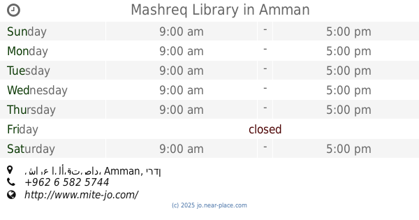
Mashreq Library
شارع الأقتصاد
Library
read more
6.045 km
مكتبة Geem
Amman
Library
read more
6.169 km
Tamari Library
عمان-المقابلين-شاع عائشة التمورية
Library
read more
6.362 km
مكتبة الشالاتي المركزي
Abd Ar-Rahim Al-Hajj Muhammad Street, Amman
Library
read more
7.672 km
Radwan Library
Amman
Library
read more
8.81 km
Abd Al Hamid Shoman Foundation
Al Kulliyah Al Elmiyah Al Eslamiyah St 15، عمّان
Library
read more
9.019 km
Sharbain Bookshop
Complex No 59, Al Rainbow St 59, Amman
Library
read more
9.321 km
Hijjawi Bookshop
Robin Complex, King Al Hussein St 224, Amman
Library
read more
10.136 km
Almiscawi Library
Amman
Library
read more
10.288 km
مكتبة الطلاب
Amman
Library
read more
10.435 km
مكتبة اسلام
شارع الإمام البخاري،، عمّان
Library
read more
13.262 km
مكتبة صويلح
Amman
Library
read more
14.171 km
Natsheh Library
Amman
Library
read more
📑
all categories
Accounting
Administrative area level 1
Administrative area level 2
Airport
Amusement park
Aquarium
Art gallery
Atm
Bakery
Bank
Bar
Beauty salon
Bicycle store
Book store
Bowling alley
Bus station
Cafe
Campground
Car dealer
Car rental
Car repair
Car wash
Cemetery
Church
City hall
Clothing store
Colloquial area
Convenience store
Country
Courthouse
Dentist
Department store
Doctor
Electrician
Electronics store
Embassy
Finance
Fire station
Florist
Food
Funeral home
Furniture store
Gas station
General contractor
Grocery or supermarket
Gym
Hair care
Hardware store
Health
Home goods store
Hospital
Insurance agency
Jewelry store
Laundry
Lawyer
Library
Liquor store
Local government office
Locality
Locksmith
Lodging
Meal delivery
Meal takeaway
Mosque
Movie rental
Movie theater
Moving company
Museum
Natural feature
Neighborhood
Night club
Painter
Park
Parking
Pet store
Pharmacy
Physiotherapist
Place of worship
Plumber
Point of interest
Police
Post office
Premise
Real estate agency
Restaurant
Route
Rv park, camping
School
Shoe store
Shopping mall
Spa
Stadium
Storage
Store
Supermarket
Taxi stand
Train station
Travel agency
University
Veterinary care
Zoo
sublocality level 1
↑