Library nearby مكتبة الاحسان
Coronavirus disease (COVID-19) Situation
confirmed cases
1746997
deaths
14122
Jordan
Library nearby مكتبة الاحسان
مكتبة الاحسان
Hizam Ring Road, Amman, Al-Kourah District, JO ירדן
contacts phone
:
+962 7 7220 1189
Latitude:
32.4100254
, Longitude:
35.7062541
larger map & directions
read more
nearest Library
665 m
مكتبة جديتا
Judayta
Library
read more
10.628 km
مكتبة كلمات للمسلزمات الطلابية
Library
read more
10.682 km
مكتبة الاستاذ عايش
Unnamed Rd
Library
read more
12.407 km
Waves Library
Ajloun
Library
read more
14.831 km
محطة معرفة الطيبة
Library
read more
16.231 km
المكتبة العلمية
166, Jerash
Library
read more
16.328 km
Romance Library
Jerash
Library
read more
16.521 km
Alshaikh Library
Jerash
Library
read more
17.492 km
مكتبة العوادين
Library
read more
19.062 km
Alwan Library
Ar-Razi Street, Irbid
Library
read more
19.233 km
مكتبة إيلاف
Irbid
Library
read more
19.342 km
مكتبة التميز
Zaki At-Tall Street, Irbid
Library
read more
19.352 km
Neseem library مكتبة النسيم
Irbid
Library
read more
19.401 km
مكتبة UNDER GROUND
Irbid
Library
read more
19.518 km
Library glimmer of certainty
ش. عدن،، إربد
Library
read more
19.588 km
مكتبة الأستاذ اربد
Irbid
Library
read more
19.662 km
Rushd Library
irbed, shafeeq ershadat st, Irbid
Library
read more
19.716 km
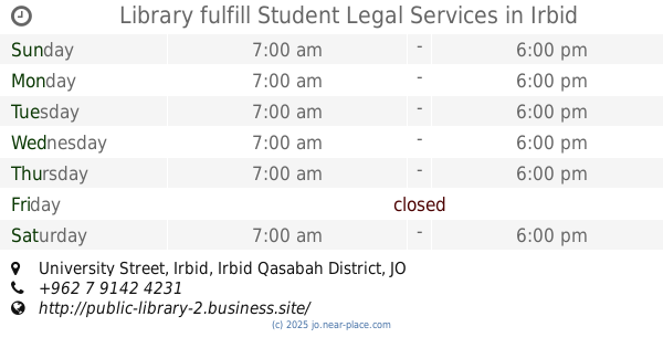
Library fulfill Student Legal Services
University Street, Irbid
Library
read more
19.942 km
Al-Husayniyyah Library
Irbid
Library
read more
19.948 km
مكتبة ميرا
Irbid
Library
read more
19.951 km
مكتبة الطلبة الجامعية
University Street, Irbid
Library
read more
19.954 km
Nermin Library
Irbid
Library
read more
19.972 km
مركز السفير الفني
Irbid
Library
read more
20.036 km
مكتبة مراد للخدمات الجامعية
Abdul Qader At-Tal Street, Irbid
Library
read more
20.386 km
Alqousor
Irbid
Library
read more
📑
all categories
Accounting
Administrative area level 1
Administrative area level 2
Airport
Amusement park
Aquarium
Art gallery
Atm
Bakery
Bank
Bar
Beauty salon
Bicycle store
Book store
Bowling alley
Bus station
Cafe
Campground
Car dealer
Car rental
Car repair
Car wash
Cemetery
Church
City hall
Clothing store
Colloquial area
Convenience store
Country
Courthouse
Dentist
Department store
Doctor
Electrician
Electronics store
Embassy
Finance
Fire station
Florist
Food
Funeral home
Furniture store
Gas station
General contractor
Grocery or supermarket
Gym
Hair care
Hardware store
Health
Home goods store
Hospital
Insurance agency
Jewelry store
Laundry
Lawyer
Library
Liquor store
Local government office
Locality
Locksmith
Lodging
Meal delivery
Meal takeaway
Mosque
Movie rental
Movie theater
Moving company
Museum
Natural feature
Neighborhood
Night club
Painter
Park
Parking
Pet store
Pharmacy
Physiotherapist
Place of worship
Plumber
Point of interest
Police
Post office
Premise
Real estate agency
Restaurant
Route
Rv park, camping
School
Shoe store
Shopping mall
Spa
Stadium
Storage
Store
Supermarket
Taxi stand
Train station
Travel agency
University
Veterinary care
Zoo
sublocality level 1
↑