Hospital nearby مركز صحي خزمة
Jordan
Hospital nearby مركز صحي خزمة
مركز صحي خزمة
מחוז בלקא, ירדן
contacts phone
:
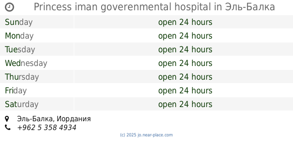
+962
Latitude:
32.2045797
, Longitude:
35.6123851
larger map & directions
read more
nearest Hospital
4.081 km
مركز صحي البلاونة
Hospital
read more
5.792 km
Princess iman goverenmental hospital
Hospital
read more
7.551 km
Agency Algot Archana Clinic
Hospital
read more
8.206 km
عيادات الكريمة الطبية
الشارع الرئيسي, Kuraymah
Hospital
read more
10.606 km
مشتفى الملكه عليا
Hizam Ring Road, Amman
Hospital
read more
10.606 km
Queen Alia Hospital
Hizam Ring Road, Amman
Hospital
read more
11.974 km
Al Safa health center
Аджлун
Hospital
read more
13.566 km
المركز الصحي- جريش
Jordan
Hospital
read more
15.453 km
مستودع الاثاث والقرطاسية
Hospital
read more
18.635 km
Al Iman Hospital
Shari Ali Bin Abi Talib, Ajloun
Hospital
read more
18.878 km
مركز صحي عجلون
Ajloun
Hospital
read more
18.931 km
Tulip Optics
Ajloun
Hospital
read more
19.341 km
Princess Iman Government Hospital
Ajloun
Hospital
read more
20.471 km
Health Center Eye Jana
Ajloun
Hospital
read more
22.313 km
مركز صحي الرازي
Hospital
read more
25.095 km
Prince Hussein Hospital
Al-Baqah
Hospital
read more
25.51 km
مركز صحي شامل كفرعوان
Hospital
read more
26.559 km
المركز الصحي -الاونروا
32°03'54. 35°50'29.0"E, 3rd Circle, Amman
Hospital
read more
31.816 km
Charisma Dental Clinic
Wasfi At-Tall Street 297, Amman
Hospital
read more
32.306 km
Welch Allyn
Wasfi At-Tall Street 257, Amman
Hospital
read more
32.866 km
مركز الاثير الطبي 24 ساعه
Amman
Hospital
read more
33.195 km
midlle east center مركز الشرق الاوسط للسمع و النطق و التوازن
Wasfi At-Tall Street, Amman
Hospital
read more
33.273 km
Alhussein Center For Cancer
Queen Rania Street 202, Amman
Hospital
read more
33.597 km
سمرين مركز طبي
Amman
Hospital
read more
33.621 km
Eye Specialty Hospital
المدينة المنورة، عمّان
Hospital
read more
📑
all categories
Accounting
Administrative area level 1
Administrative area level 2
Airport
Amusement park
Aquarium
Art gallery
Atm
Bakery
Bank
Bar
Beauty salon
Bicycle store
Book store
Bowling alley
Bus station
Cafe
Campground
Car dealer
Car rental
Car repair
Car wash
Cemetery
Church
City hall
Clothing store
Colloquial area
Convenience store
Country
Courthouse
Dentist
Department store
Doctor
Electrician
Electronics store
Embassy
Finance
Fire station
Florist
Food
Funeral home
Furniture store
Gas station
General contractor
Grocery or supermarket
Gym
Hair care
Hardware store
Health
Home goods store
Hospital
Insurance agency
Jewelry store
Laundry
Lawyer
Library
Liquor store
Local government office
Locality
Locksmith
Lodging
Meal delivery
Meal takeaway
Mosque
Movie rental
Movie theater
Moving company
Museum
Natural feature
Neighborhood
Night club
Painter
Park
Parking
Pet store
Pharmacy
Physiotherapist
Place of worship
Plumber
Point of interest
Police
Post office
Premise
Real estate agency
Restaurant
Route
Rv park, camping
School
Shoe store
Shopping mall
Spa
Stadium
Storage
Store
Supermarket
Taxi stand
Train station
Travel agency
University
Veterinary care
Zoo
sublocality level 1
↑