Hospital nearby Government Karama Hospital
Jordan
Hospital nearby Government Karama Hospital
Government Karama Hospital
מחוז בלקא, ירדן
contacts phone
:
+962
Latitude:
31.90181
, Longitude:
35.6284388
larger map & directions
read more
nearest Hospital
29 m
مستشفى الشونة الجنوبية
Hospital
read more
11.631 km
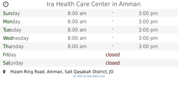
Ira Health Care Center
Hizam Ring Road, Amman
Hospital
read more
15.184 km
King Hussein Institute for Biotechnology and Cancer
Amman
Hospital
read more
16.182 km
مركز صحي بدر الجديدة
Amman
Hospital
read more
16.896 km
Psychiatry / Fhais Hospital
Mahis
Hospital
read more
16.918 km
مستشفى الفحيص
32.001306,772075, 35
Hospital
read more
16.919 km
المركز الوطني للصحة النفسية
Jordan
Hospital
read more
17.341 km
مركز صحي الفحيص
Hospital
read more
17.444 km
عيادة ليونز الفحيص
Hospital
read more
17.667 km
Al-Midan Health Center
As-Salt
Hospital
read more
17.906 km
Al-Hussein Hospital, Salt
As-Salt
Hospital
read more
17.947 km
Salt General Hospital
As-Salt
Hospital
read more
17.952 km
Hussein Hospital
As-Salt
Hospital
read more
17.983 km
Больница Аль Хассейн Паблик
As-Salt
Hospital
read more
18.773 km
Fuheis Eye Clinic عياده الفحيص للعيون
Al-Fuhais Circle
Hospital
read more
19.378 km
مركز صحي العريش
Amman
Hospital
read more
20.968 km
QAHI
King Hussein Medical Center,, Amman
Hospital
read more
22.742 km
مركز الاثير الطبي 24 ساعه
Amman
Hospital
read more
24.23 km
midlle east center مركز الشرق الاوسط للسمع و النطق و التوازن
Wasfi At-Tall Street, Amman
Hospital
read more
24.737 km
Al Yasmeen Medical Lab MedLabs
Land Mark Complex, Jabal Arafat Street 60, Amman
Hospital
read more
25.935 km
Alhussein Center For Cancer
Queen Rania Street 202, Amman
Hospital
read more
25.945 km
Madaba Camp Health Center
Yafa, Madaba
Hospital
read more
26.06 km
Al-Zaytoonah medical centre
Amman
Hospital
read more
27.562 km
Intersection Manja mosque and a health center Manja
Amman
Hospital
read more
28.122 km
Prince Hussein Hospital
Al-Baqah
Hospital
read more
📑
all categories
Accounting
Administrative area level 1
Administrative area level 2
Airport
Amusement park
Aquarium
Art gallery
Atm
Bakery
Bank
Bar
Beauty salon
Bicycle store
Book store
Bowling alley
Bus station
Cafe
Campground
Car dealer
Car rental
Car repair
Car wash
Cemetery
Church
City hall
Clothing store
Colloquial area
Convenience store
Country
Courthouse
Dentist
Department store
Doctor
Electrician
Electronics store
Embassy
Finance
Fire station
Florist
Food
Funeral home
Furniture store
Gas station
General contractor
Grocery or supermarket
Gym
Hair care
Hardware store
Health
Home goods store
Hospital
Insurance agency
Jewelry store
Laundry
Lawyer
Library
Liquor store
Local government office
Locality
Locksmith
Lodging
Meal delivery
Meal takeaway
Mosque
Movie rental
Movie theater
Moving company
Museum
Natural feature
Neighborhood
Night club
Painter
Park
Parking
Pet store
Pharmacy
Physiotherapist
Place of worship
Plumber
Point of interest
Police
Post office
Premise
Real estate agency
Restaurant
Route
Rv park, camping
School
Shoe store
Shopping mall
Spa
Stadium
Storage
Store
Supermarket
Taxi stand
Train station
Travel agency
University
Veterinary care
Zoo
sublocality level 1
↑