Health nearby مركز صحي المبروكه
Jordan
Health nearby مركز صحي المبروكه
مركز صحي المبروكه
Al-Mafrak, Jordania
contacts phone
:
+962 7 9556 4604
website:
www.moh.gov.jo
Latitude:
32.1628944
, Longitude:
36.2854687
larger map & directions
read more
nearest Health
3.18 km
Al Khaldiyah Health Center
Health
read more
3.287 km
صيدلية نبض الحياه
Khaldiyah Sub-District
Health
read more
4.453 km
Vapco Factory
king hussain street dulail, Az-Zarqa
Health
read more
4.641 km
General Medicine Clinic
Army Street, Dhlail
Health
read more
4.712 km
عيادة التفاح الأخضر الطبية
Health
read more
4.991 km
A civil defense center Dilal
Health
read more
5.087 km
Health Center arching
Health
read more
5.936 km
Civil Defense Center
Health
read more
11.326 km
المركز الصحي
Az-Zarqa
Health
read more
19.421 km
عيادة الديار الطبية
Az-Zarqa
Health
read more
19.814 km
مركز ابن النفيس
Al-Mafraq
Health
read more
20.114 km
مركز قوة اللياقة للياقة البدنية
البتراوي،, Az-Zarqa
Health
read more
20.228 km
Dr. Mohammad Al Azzam clinic
Az-Zarqa
Health
read more
20.331 km
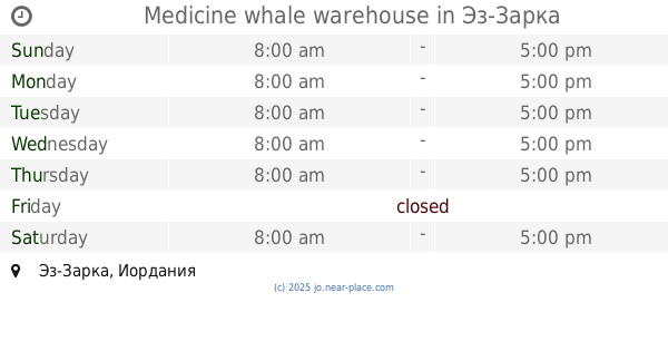
Medicine whale warehouse
Az-Zarqa
Health
read more
20.359 km
Medical Clinic soothes
Az-Zarqa
Health
read more
20.951 km
Government outpatient clinics
Az-Zarqa
Health
read more
21.106 km
عيادة الدكتورة فاطمة الشديفات
Al-Mafraq
Health
read more
21.163 km
مركز حماية الاسرة
Army Street, Az-Zarqa
Health
read more
21.199 km
عيادة د. احمد ياسين التلاوي
Az-Zarqa
Health
read more
21.661 km
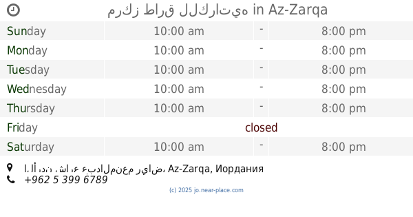
مركز طارق للكراتيه
الأردن شارع عبدالمنعم رياض
Health
read more
22.034 km
Pharmacy1 -maasom
Az-Zarqa
Health
read more
22.401 km
صيدلية فيتامين
Az-Zarqa-alzohour street
Health
read more
24.572 km
Retaj Pharmaceuticals Industries
Health
read more
26.691 km
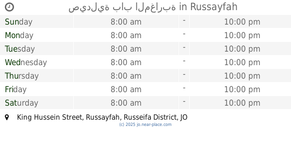
صيدلية باب المغاربة
King Hussein Street, Russayfah
Health
read more
30.502 km
مركز صحي النقب
لواء الرصيفة،, Russayfah
Health
read more
📑
all categories
Accounting
Administrative area level 1
Administrative area level 2
Airport
Amusement park
Aquarium
Art gallery
Atm
Bakery
Bank
Bar
Beauty salon
Bicycle store
Book store
Bowling alley
Bus station
Cafe
Campground
Car dealer
Car rental
Car repair
Car wash
Cemetery
Church
City hall
Clothing store
Colloquial area
Convenience store
Country
Courthouse
Dentist
Department store
Doctor
Electrician
Electronics store
Embassy
Finance
Fire station
Florist
Food
Funeral home
Furniture store
Gas station
General contractor
Grocery or supermarket
Gym
Hair care
Hardware store
Health
Home goods store
Hospital
Insurance agency
Jewelry store
Laundry
Lawyer
Library
Liquor store
Local government office
Locality
Locksmith
Lodging
Meal delivery
Meal takeaway
Mosque
Movie rental
Movie theater
Moving company
Museum
Natural feature
Neighborhood
Night club
Painter
Park
Parking
Pet store
Pharmacy
Physiotherapist
Place of worship
Plumber
Point of interest
Police
Post office
Premise
Real estate agency
Restaurant
Route
Rv park, camping
School
Shoe store
Shopping mall
Spa
Stadium
Storage
Store
Supermarket
Taxi stand
Train station
Travel agency
University
Veterinary care
Zoo
sublocality level 1
↑