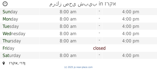
Health nearby الماسة لطب الاسنان - الدكتور محمد زلوم
Jordan
Health nearby الماسة لطب الاسنان - الدكتور محمد زلوم
الماسة لطب الاسنان - الدكتور محمد زلوم
Эз-Зарка, Иордания
contacts phone
:
+962 7 9785 0309
Latitude:
32.0744287
, Longitude:
36.0735873
larger map & directions
read more
nearest Health
338 m
مختبرات المثالية
البساتين،, Az-Zarqa
Health
read more
362 m
Pharmaceutical Dibaj warehouse
Az-Zarqa
Health
read more
460 m
Pharmacy1 -maasom
Az-Zarqa
Health
read more
710 m
Ibn Al-Haytham Medical Clinic
Az-Zarqa
Health
read more
761 m
صيدلية جيوس
Az-Zarqa
Health
read more
992 m
Medical Center innocence
Az-Zarqa
Health
read more
1.016 km
مركز صحي الزواهرة الاولي
Az-Zarqa
Health
read more
1.298 km
Government outpatient clinics
Az-Zarqa
Health
read more
1.447 km
مركز صحي شبيب
Az-Zarqa
Health
read more
1.548 km
Crescent Medical Clinics
Az-Zarqa
Health
read more
1.588 km
Medical secretary compound
Az-Zarqa
Health
read more
1.597 km
صيدلية فيتامين
Az-Zarqa-alzohour street
Health
read more
1.733 km
دواكم ش36
Unnamed Rd
Health
read more
1.885 km
Medical Clinic soothes
Az-Zarqa
Health
read more
1.9 km
International Center for Optics
Az-Zarqa
Health
read more
1.903 km
صيدلية الحياة
Az-Zarqa
Health
read more
1.931 km
الجمعية الاردنية لتنظيم وحماية الاسرة
Az-Zarqa
Health
read more
1.945 km
Dr. Magdy Nuseirat Medical Clinic
Az-Zarqa
Health
read more
1.954 km
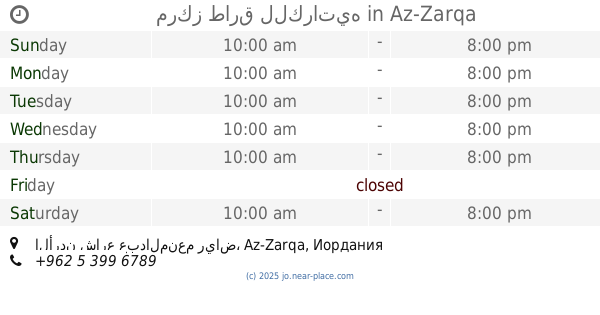
مختبرات جمال أبو فرحة للتحاليل الطبية (البرغوثي / سابقاً)
شارع السعادة - سوق عميرة التجاري - بناية رقم 63 - بالقرب من صيدلية السعادة ، Al, Az-Zarqa
Health
read more
2.008 km
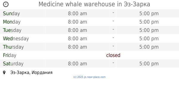
Medicine whale warehouse
Az-Zarqa
Health
read more
2.061 km
مركز طارق للكراتيه
الأردن شارع عبدالمنعم رياض
Health
read more
2.077 km
مختبرات البتراوي الطبية الحديثة
شارع 36 مكة المكرمة.مختبرات البتراوي الطبية, Az-Zarqa
Health
read more
2.328 km
عيادة د. احمد ياسين التلاوي
Az-Zarqa
Health
read more
2.359 km
مركز حماية الاسرة
Army Street, Az-Zarqa
Health
read more
2.8 km
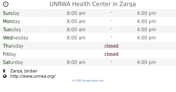
UNRWA Health Center
Az-Zarqa
Health
read more
📑
all categories
Accounting
Administrative area level 1
Administrative area level 2
Airport
Amusement park
Aquarium
Art gallery
Atm
Bakery
Bank
Bar
Beauty salon
Bicycle store
Book store
Bowling alley
Bus station
Cafe
Campground
Car dealer
Car rental
Car repair
Car wash
Cemetery
Church
City hall
Clothing store
Colloquial area
Convenience store
Country
Courthouse
Dentist
Department store
Doctor
Electrician
Electronics store
Embassy
Finance
Fire station
Florist
Food
Funeral home
Furniture store
Gas station
General contractor
Grocery or supermarket
Gym
Hair care
Hardware store
Health
Home goods store
Hospital
Insurance agency
Jewelry store
Laundry
Lawyer
Library
Liquor store
Local government office
Locality
Locksmith
Lodging
Meal delivery
Meal takeaway
Mosque
Movie rental
Movie theater
Moving company
Museum
Natural feature
Neighborhood
Night club
Painter
Park
Parking
Pet store
Pharmacy
Physiotherapist
Place of worship
Plumber
Point of interest
Police
Post office
Premise
Real estate agency
Restaurant
Route
Rv park, camping
School
Shoe store
Shopping mall
Spa
Stadium
Storage
Store
Supermarket
Taxi stand
Train station
Travel agency
University
Veterinary care
Zoo
sublocality level 1
↑