Gym nearby Jordan Health Aid Society JHAS Clinic . جمعية العون الصحي
Jordan
Gym nearby Jordan Health Aid Society JHAS Clinic . جمعية العون الصحي
Jordan Health Aid Society JHAS Clinic . جمعية العون الصحي
76, King Abdullah Ist St, Amman, JO Иордания
contacts phone
:
+962 6 465 1772
website:
www.jordanhealthaid.org
Latitude:
31.95457
, Longitude:
35.9540892
larger map & directions
read more
nearest Gym
1.191 km
مركز الاميرة بسمه
Al-Hashemi Street, Amman
Gym
read more
1.198 km
Life Style Fitness
Amman
Gym
read more
1.425 km
اوكسجين جيم ابو جاسم
ش. أبو طالب،، عمّان
Gym
read more
1.599 km
صالة جنداس
Amman
Gym
read more
1.624 km
مركز النجار للكراتيه
Amman
Gym
read more
1.658 km
Haan Homeland
Amman
Gym
read more
1.697 km
نادي Star Fitnees
القصور،، عمّان،
Gym
read more
1.75 km
Pump Gym
شارع الإمام البخاري،، عمّان
Gym
read more
1.865 km
Pump Gym
عمان حي ام تينه،، ش. الإمام البخاري،، عمّان،
Gym
read more
1.914 km
Al-Aqsa International Academy of Karate
Amman
Gym
read more
2.106 km
Jafra Turkish Bath
9th of Sha'aban Street 37, Amman
Gym
read more
2.393 km
الجمر
King Hussein Street, Amman
Gym
read more
2.449 km
Paris Fitness GYM مركز باريس لبناء الأجسام - جيم
Paris Circle, Jabal Weilbdeh, POBox 910372, Amman
Gym
read more
2.458 km
Wider
Amman
Gym
read more
2.527 km
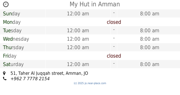
My Hut Room on the Street
Taher Al Juqqah street 51, Amman
Gym
read more
2.527 km
My Hut
Taher Al Juqqah street 51, Amman
Gym
read more
2.55 km
صالون العبسي
Amman
Gym
read more
2.706 km
نادي الاقصى الرياضي
Abu Dhabi Street, Amman
Gym
read more
2.853 km
Fitness Magic
Complex No 74, Saleh Hasan Al Hamlan St 74, Amman
Gym
read more
2.855 km
فينتس ماجيك
الربوة،, Amman
Gym
read more
2.892 km
عرين الاسد
Amman
Gym
read more
2.97 km
نادي الاحلام للياقة البدنية
Amman
Gym
read more
3.004 km
Club Greater Amman Municipality
جبل النزهة، عمّان
Gym
read more
3.797 km
Lafi For Sports
Complex No 327, King Abdullah Ist St 327, Amman
Gym
read more
3.9 km
قلب الاسد للكارتيه
Fatima Az Zahra, Amman
Gym
read more
📑
all categories
Accounting
Administrative area level 1
Administrative area level 2
Airport
Amusement park
Aquarium
Art gallery
Atm
Bakery
Bank
Bar
Beauty salon
Bicycle store
Book store
Bowling alley
Bus station
Cafe
Campground
Car dealer
Car rental
Car repair
Car wash
Cemetery
Church
City hall
Clothing store
Colloquial area
Convenience store
Country
Courthouse
Dentist
Department store
Doctor
Electrician
Electronics store
Embassy
Finance
Fire station
Florist
Food
Funeral home
Furniture store
Gas station
General contractor
Grocery or supermarket
Gym
Hair care
Hardware store
Health
Home goods store
Hospital
Insurance agency
Jewelry store
Laundry
Lawyer
Library
Liquor store
Local government office
Locality
Locksmith
Lodging
Meal delivery
Meal takeaway
Mosque
Movie rental
Movie theater
Moving company
Museum
Natural feature
Neighborhood
Night club
Painter
Park
Parking
Pet store
Pharmacy
Physiotherapist
Place of worship
Plumber
Point of interest
Police
Post office
Premise
Real estate agency
Restaurant
Route
Rv park, camping
School
Shoe store
Shopping mall
Spa
Stadium
Storage
Store
Supermarket
Taxi stand
Train station
Travel agency
University
Veterinary care
Zoo
sublocality level 1
↑