Grocery or supermarket nearby Grocery faith
Jordan
Grocery or supermarket nearby Grocery faith
Grocery faith
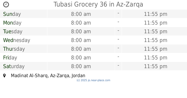
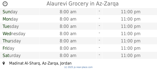
Madinat Al-Sharq, Az-Zarqa, Иордания
contacts phone
:
+962
Latitude:
32.0826805
, Longitude:
36.0934202
larger map & directions
read more
nearest Grocery or supermarket
256 m
Abu Riad Grocery
Az-Zarqa
Grocery or supermarket
read more
259 m
Burgess Grocery
Az-Zarqa
Grocery or supermarket
read more
344 m
Aoun Supermarket
Az-Zarqa
Grocery or supermarket
read more
367 m
Tubasi Grocery 36
Az-Zarqa
Grocery or supermarket
read more
381 m
سوبر ماركت الريان
Az-Zarqa
Grocery or supermarket
read more
387 m
Markets the time of Al-Ahmad
Az-Zarqa
Grocery or supermarket
read more
480 m
Al Kholoud Supermarket
Az-Zarqa
Grocery or supermarket
read more
500 m
Alaurevi Grocery
Az-Zarqa
Grocery or supermarket
read more
542 m
Al-Basha Supermarket
Az-Zarqa
Grocery or supermarket
read more
569 m
Wei Super Market Safadi
Az-Zarqa
Grocery or supermarket
read more
610 m
سوبر ماركت ابن سينا
Az-Zarqa
Grocery or supermarket
read more
620 m
بقالة لمار للمواد التموينية
Az-Zarqa
Grocery or supermarket
read more
670 m
اوس ميني ماركت
Az-Zarqa
Grocery or supermarket
read more
743 m
Lian Grocery
Az-Zarqa
Grocery or supermarket
read more
782 m
Khawaldeh for Fruits and Vegetables
Az-Zarqa
Grocery or supermarket
read more
849 m
Noor Grocery
Az-Zarqa
Grocery or supermarket
read more
875 m
بقالة ابو صياح
الامير محمد،, Az-Zarqa
Grocery or supermarket
read more
877 m
Al-Samah Mini Market
Az-Zarqa
Grocery or supermarket
read more
891 m
Al Yousuf Foodstuff
Az-Zarqa
Grocery or supermarket
read more
925 m
الواحة للخضار والفواكة
Az-Zarqa
Grocery or supermarket
read more
930 m
اسواق جبل المكبر الاستهلاكية
Az-Zarqa
Grocery or supermarket
read more
960 m
Hamada commercial markets
Az-Zarqa
Grocery or supermarket
read more
987 m
Muammar Super Market
Army Street, Az-Zarqa
Grocery or supermarket
read more
1.012 km
Princess Mini Market
Az-Zarqa
Grocery or supermarket
read more
1.055 km
بقالة الاتحاد
Az-Zarqa
Grocery or supermarket
read more
📑
all categories
Accounting
Administrative area level 1
Administrative area level 2
Airport
Amusement park
Aquarium
Art gallery
Atm
Bakery
Bank
Bar
Beauty salon
Bicycle store
Book store
Bowling alley
Bus station
Cafe
Campground
Car dealer
Car rental
Car repair
Car wash
Cemetery
Church
City hall
Clothing store
Colloquial area
Convenience store
Country
Courthouse
Dentist
Department store
Doctor
Electrician
Electronics store
Embassy
Finance
Fire station
Florist
Food
Funeral home
Furniture store
Gas station
General contractor
Grocery or supermarket
Gym
Hair care
Hardware store
Health
Home goods store
Hospital
Insurance agency
Jewelry store
Laundry
Lawyer
Library
Liquor store
Local government office
Locality
Locksmith
Lodging
Meal delivery
Meal takeaway
Mosque
Movie rental
Movie theater
Moving company
Museum
Natural feature
Neighborhood
Night club
Painter
Park
Parking
Pet store
Pharmacy
Physiotherapist
Place of worship
Plumber
Point of interest
Police
Post office
Premise
Real estate agency
Restaurant
Route
Rv park, camping
School
Shoe store
Shopping mall
Spa
Stadium
Storage
Store
Supermarket
Taxi stand
Train station
Travel agency
University
Veterinary care
Zoo
sublocality level 1
↑