Gas station nearby Total fuel station
Jordan
Gas station nearby Total fuel station
Total fuel station
Эль-Карак, Иордания
contacts phone
:
+962
Latitude:
31.2861904
, Longitude:
35.7413841
larger map & directions
read more
nearest Gas station
7.866 km
Total fuel station
Kerak
Gas station
read more
8.829 km
محطة المناصير للمحروقات
Kerak
Gas station
read more
11.481 km
Fuel Torrent Station
Kerak
Gas station
read more
11.617 km
Jobtrul Station
Al-Yarmouk Street, Kerak
Gas station
read more
11.883 km
Jo Petrol
Kerak
Gas station
read more
12.625 km
مجمع باصات الجسر
Kerak
Gas station
read more
13.461 km
محطة محروقات المناصير
Kerak
Gas station
read more
13.468 km
شركة المناصير للزيوت والمحروقات
الثنية، طريق جامعة مؤتة, Kerak
Gas station
read more
13.756 km
Gas station / Mahsiri
35, Kerak
Gas station
read more
14.441 km
Petrol station
Kerak
Gas station
read more
20.943 km
Mutah Fuel Station
Gas station
read more
22.745 km
Total petrol
Gas station
read more
41.976 km
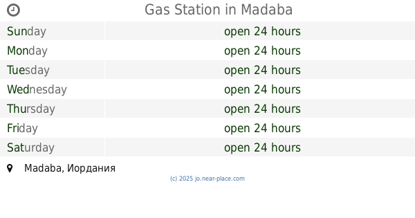
Gas Station
Madaba
Gas station
read more
43.401 km
Dabaa Petrol Station
Dab'a
Gas station
read more
46.686 km
Petrol station
Madaba
Gas station
read more
46.818 km
Fuel Abajla station
Madaba
Gas station
read more
47.319 km
Belal Fuel Station
Ibn Kathir Street, Madaba
Gas station
read more
47.464 km
Gasolinera Madaba
Madaba
Gas station
read more
48.321 km
Total Madaba - توتال مادبا
Al Hamd, Madaba
Gas station
read more
48.398 km
Go gas Jordan, Al Watanieh
Desert Highway, Amman
Gas station
read more
48.555 km
محطة القريوتي للمحروقات
Madaba
Gas station
read more
48.76 km
Manaseer Oil & Gas
Manaseer Oil & Gas, Queen Alia Airport St 1166, Amman
Gas station
read more
49.195 km
محطة وقود Jo
Amman
Gas station
read more
49.221 km
MANASEER Express محطة ابو شهاب الشخاترة
Maadaba Al-Gharbi Street, Madaba
Gas station
read more
51.339 km
Jeezeh Station
Amman
Gas station
read more
📑
all categories
Accounting
Administrative area level 1
Administrative area level 2
Airport
Amusement park
Aquarium
Art gallery
Atm
Bakery
Bank
Bar
Beauty salon
Bicycle store
Book store
Bowling alley
Bus station
Cafe
Campground
Car dealer
Car rental
Car repair
Car wash
Cemetery
Church
City hall
Clothing store
Colloquial area
Convenience store
Country
Courthouse
Dentist
Department store
Doctor
Electrician
Electronics store
Embassy
Finance
Fire station
Florist
Food
Funeral home
Furniture store
Gas station
General contractor
Grocery or supermarket
Gym
Hair care
Hardware store
Health
Home goods store
Hospital
Insurance agency
Jewelry store
Laundry
Lawyer
Library
Liquor store
Local government office
Locality
Locksmith
Lodging
Meal delivery
Meal takeaway
Mosque
Movie rental
Movie theater
Moving company
Museum
Natural feature
Neighborhood
Night club
Painter
Park
Parking
Pet store
Pharmacy
Physiotherapist
Place of worship
Plumber
Point of interest
Police
Post office
Premise
Real estate agency
Restaurant
Route
Rv park, camping
School
Shoe store
Shopping mall
Spa
Stadium
Storage
Store
Supermarket
Taxi stand
Train station
Travel agency
University
Veterinary care
Zoo
sublocality level 1
↑