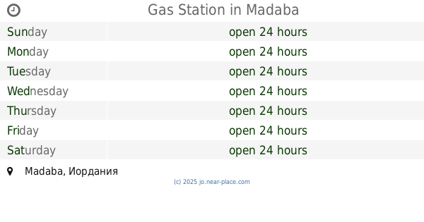
Gas station nearby Jawasrh triangle
Jordan
Gas station nearby Jawasrh triangle
Jawasrh triangle
مثلث الجواسرة, ירדן
contacts phone
:
+962
Latitude:
31.8617299
, Longitude:
35.6297839
larger map & directions
read more
nearest Gas station
4.356 km
Jet Gas Station
Gas station
read more
5.934 km
محطة المناصير للمحروقات
Gas station
read more
6.217 km
محطة المناصير للمحروقات
65
Gas station
read more
9.899 km
Saleh Abu Teen Gaz Station Co. Dead Sea
Jordan Valley Highway Governorate, Aqaba
Gas station
read more
10.717 km
Karameh Petrol Station
Gas station
read more
10.723 km
KARAMEH Petrol Station
Karameh
Gas station
read more
13.999 km
Total Gas Station
Amman
Gas station
read more
21.056 km
Total Marj Al Hamam - توتال مرج الحمام
Al Quds St, Marj al Hamam, Amman
Gas station
read more
21.746 km
Castrol Marj Petrol Station
Amman
Gas station
read more
22.145 km
Petrol station
Madaba
Gas station
read more
22.544 km
Manaseer Gas Station
Queen Alia Airport Road, Amman
Gas station
read more
22.893 km
Gasolinera Madaba
Madaba
Gas station
read more
23.175 km
Oil express
Muhammad Ad-Daajah Street, Amman
Gas station
read more
23.286 km
Total Gas Station
Madaba
Gas station
read more
23.481 km
Total Petrol Station
Amman
Gas station
read more
24.501 km
محطة محروقات المناصير
Al Rawabi, Amman
Gas station
read more
24.656 km
Total Airport Road 1 - توتال شارع المطار 1
Airport Road, King Abdallah II Street, 15, Amman
Gas station
read more
25.48 km
total gas station. near zayi
As-Salt
Gas station
read more
26.483 km
Manaseer Oil & Gas
Manaseer Oil & Gas, Mecca Al Mukarramah St 11, Amman
Gas station
read more
26.499 km
Gas Station
Madaba
Gas station
read more
28.172 km
Gulf
Al Jamia, Amman
Gas station
read more
28.214 km
Total
Queen Rania Street 317, Amman
Gas station
read more
28.295 km
Mandarin Gas Station
Mandarin Gas Station, Ghazi Arabiyat St 4, Amman
Gas station
read more
28.734 km
كراج ابوشاويش للمكانيك
Gas station
read more
29.127 km
Al Loozi Gas Station - محطة اللوزي للمحروقات
Amman
Gas station
read more
📑
all categories
Accounting
Administrative area level 1
Administrative area level 2
Airport
Amusement park
Aquarium
Art gallery
Atm
Bakery
Bank
Bar
Beauty salon
Bicycle store
Book store
Bowling alley
Bus station
Cafe
Campground
Car dealer
Car rental
Car repair
Car wash
Cemetery
Church
City hall
Clothing store
Colloquial area
Convenience store
Country
Courthouse
Dentist
Department store
Doctor
Electrician
Electronics store
Embassy
Finance
Fire station
Florist
Food
Funeral home
Furniture store
Gas station
General contractor
Grocery or supermarket
Gym
Hair care
Hardware store
Health
Home goods store
Hospital
Insurance agency
Jewelry store
Laundry
Lawyer
Library
Liquor store
Local government office
Locality
Locksmith
Lodging
Meal delivery
Meal takeaway
Mosque
Movie rental
Movie theater
Moving company
Museum
Natural feature
Neighborhood
Night club
Painter
Park
Parking
Pet store
Pharmacy
Physiotherapist
Place of worship
Plumber
Point of interest
Police
Post office
Premise
Real estate agency
Restaurant
Route
Rv park, camping
School
Shoe store
Shopping mall
Spa
Stadium
Storage
Store
Supermarket
Taxi stand
Train station
Travel agency
University
Veterinary care
Zoo
sublocality level 1
↑