Gas station nearby Al Fouad Petrol Station
Jordan
Gas station nearby Al Fouad Petrol Station
Al Fouad Petrol Station
אירביד, ירדן
contacts phone
:
+962 7 9198 6192
website:
www.megnas1.yoo7.com
Latitude:
32.5009574
, Longitude:
35.861788
larger map & directions
read more
nearest Gas station
664 m
Aydoun Gas Station
Gas station
read more
1.33 km
Ashour Gas Station
25
Gas station
read more
1.433 km
Manaseer Gaz Station محطة المناصير
35
Gas station
read more
1.62 km
Manaseer Gas Station
Gas station
read more
1.724 km
Al Manaseer Gas Station
Gas station
read more
2.238 km
جوبترول
Gas station
read more
3.269 km
محطة شاهين
Gas station
read more
3.366 km
Total Petrol Station
Irbid Qasabah District, Irbid
Gas station
read more
3.366 km
Тотал
Irbid Qasabah District, Irbid
Gas station
read more
3.373 km
Total Gas Station
25, Aydoun
Gas station
read more
3.645 km
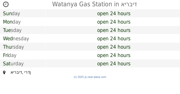
Watanya Gas Station
Irbid
Gas station
read more
4.218 km
Rjoub Gas station
Habaka
Gas station
read more
4.817 km
Manaseer Gas Station
25, Irbid
Gas station
read more
4.832 km
محطة الحكيم لخدمة السيارات
Al Hikmah, Irbid
Gas station
read more
5.055 km
Gas Station
مدرسة حوارة الثانوية للبنين, البتراء, Irbid
Gas station
read more
5.071 km
محطة حوارة
Gas station
read more
5.905 km
محطة المزار الشمالي
Gas station
read more
6.08 km
Total
Irbid
Gas station
read more
6.784 km
محطة الشمال الحديثة للمحروقات
Bani Obeid District، Amman irbid highway، Irbid
Gas station
read more
6.932 km
محطة بنزين JoPetrol
Irbid
Gas station
read more
7.419 km
North Station Irbid
An-Nour Street, Irbid
Gas station
read more
9.028 km
Sal fuel station
Sal
Gas station
read more
13.828 km
Gas Station nughayr
Gas station
read more
14.735 km
Petrol Station محطة طبريا للمحروقات
Gas station
read more
15.543 km
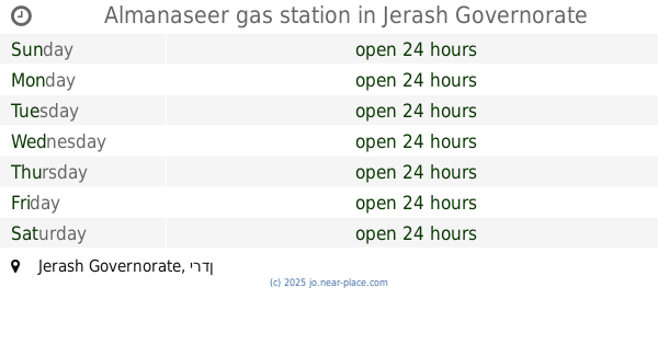
Almanaseer gas station
Gas station
read more
📑
all categories
Accounting
Administrative area level 1
Administrative area level 2
Airport
Amusement park
Aquarium
Art gallery
Atm
Bakery
Bank
Bar
Beauty salon
Bicycle store
Book store
Bowling alley
Bus station
Cafe
Campground
Car dealer
Car rental
Car repair
Car wash
Cemetery
Church
City hall
Clothing store
Colloquial area
Convenience store
Country
Courthouse
Dentist
Department store
Doctor
Electrician
Electronics store
Embassy
Finance
Fire station
Florist
Food
Funeral home
Furniture store
Gas station
General contractor
Grocery or supermarket
Gym
Hair care
Hardware store
Health
Home goods store
Hospital
Insurance agency
Jewelry store
Laundry
Lawyer
Library
Liquor store
Local government office
Locality
Locksmith
Lodging
Meal delivery
Meal takeaway
Mosque
Movie rental
Movie theater
Moving company
Museum
Natural feature
Neighborhood
Night club
Painter
Park
Parking
Pet store
Pharmacy
Physiotherapist
Place of worship
Plumber
Point of interest
Police
Post office
Premise
Real estate agency
Restaurant
Route
Rv park, camping
School
Shoe store
Shopping mall
Spa
Stadium
Storage
Store
Supermarket
Taxi stand
Train station
Travel agency
University
Veterinary care
Zoo
sublocality level 1
↑