Food nearby شركة البوادي الزراعية
Jordan
Food nearby شركة البوادي الزراعية
شركة البوادي الزراعية
Эз-Зарка, Иордания
contacts phone
:
+962 7 8144 8804
Latitude:
32.077665
, Longitude:
36.390153
larger map & directions
read more
nearest Food
9.773 km
مسلخ دجاج حموده
Food
read more
12.49 km
الزرقاء الضليل
Unnamed Road, Dhlail
Food
read more
12.679 km
Mehyar Hyber Market
Food
read more
14.205 km
شركة المهرة للصناعات الغذائية
Food
read more
14.733 km
شركة الانماء العربية للصناعات الغذائية
Az-Zarqa
Food
read more
17.069 km
Mahmoud Kanaan & Partners Co.
Az-Zarqa
Food
read more
17.804 km
شركة البلقان الصناعية
لواء قصبة, Az-Zarqa
Food
read more
21.159 km
شركة الجزيرة الزراعية
Unnamed Road, Salheyah
Food
read more
25.546 km
الطوباسي للاحتفالات والمناسبات
Food
read more
25.569 km
Bakery Kheir Zaman
Food
read more
27.816 km
Freezers Hamza Sailawi 1
Az-Zarqa
Food
read more
27.818 km
Refreshments Abu acid
Az-Zarqa
Food
read more
28.296 km
Abu al-Laban Sweets
Al-Saadeh Street, Az-Zarqa
Food
read more
31.191 km
سوق الحلال-امانة عمان الكبرى
Amman
Food
read more
31.92 km
حلويات روعة الشرق / Rawe't Alsharq Sweets
Yajouz Road, Russayfah
Food
read more
42.468 km
Al Houtary Trading Co
Complex No 72, Al Yarmouk St 72, Amman
Food
read more
46.71 km
Jerashco Clean
Abed Aljawad Hassouna Complex, Khaled Ben Al Walid St, Amman
Food
read more
46.845 km
سوق الوحدات الشعبي
Amman
Food
read more
48.195 km
international center for geotechnical studies (Laboratory)
Amman
Food
read more
48.315 km
مطبخ وحلويات عامر وعمار
Amman
Food
read more
48.547 km
محلات مامون قزاز
Al-Kifah Street 35, Amman
Food
read more
49.844 km
حلويات البيت الدمشقي
al-madinh al-monawara street building 229, Amman
Food
read more
54.788 km
Mix Zalatimo Sweets
Queen Alia Airport Road 867, Amman
Food
read more
57.436 km
شركة الدرة للمنتجات الغذائية
Ramtha
Food
read more
58.138 km
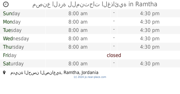
مصنع الدرة للمنتجات الغذائية
مدينة الحسن الصناعية
Food
read more
📑
all categories
Accounting
Administrative area level 1
Administrative area level 2
Airport
Amusement park
Aquarium
Art gallery
Atm
Bakery
Bank
Bar
Beauty salon
Bicycle store
Book store
Bowling alley
Bus station
Cafe
Campground
Car dealer
Car rental
Car repair
Car wash
Cemetery
Church
City hall
Clothing store
Colloquial area
Convenience store
Country
Courthouse
Dentist
Department store
Doctor
Electrician
Electronics store
Embassy
Finance
Fire station
Florist
Food
Funeral home
Furniture store
Gas station
General contractor
Grocery or supermarket
Gym
Hair care
Hardware store
Health
Home goods store
Hospital
Insurance agency
Jewelry store
Laundry
Lawyer
Library
Liquor store
Local government office
Locality
Locksmith
Lodging
Meal delivery
Meal takeaway
Mosque
Movie rental
Movie theater
Moving company
Museum
Natural feature
Neighborhood
Night club
Painter
Park
Parking
Pet store
Pharmacy
Physiotherapist
Place of worship
Plumber
Point of interest
Police
Post office
Premise
Real estate agency
Restaurant
Route
Rv park, camping
School
Shoe store
Shopping mall
Spa
Stadium
Storage
Store
Supermarket
Taxi stand
Train station
Travel agency
University
Veterinary care
Zoo
sublocality level 1
↑