Food nearby محمص حسني
Jordan
Food nearby محمص حسني
محمص حسني
Basman, Amman, Jordania
contacts phone
:
+962
Latitude:
31.9698861
, Longitude:
35.9302557
larger map & directions
read more
nearest Food
992 m
حلويات هشام أبوسير
Amman
Food
read more
1.597 km
مقهى جبل الحسين
Amman
Food
read more
1.877 km
Jerashco Clean
Abed Aljawad Hassouna Complex, Khaled Ben Al Walid St, Amman
Food
read more
1.914 km
Al Amal Butchery
Al Shurouq Complex, Al Bathaa St 81, Amman
Food
read more
1.923 km
Midgulf International Ltd.
222 King Hussein St., Al-Abdali, Akarko Building, 9th Floor
Food
read more
1.923 km
waffle crunch
Al-Bathaa Street 74،, عمّان،
Food
read more
1.935 km
Habiba Sweet
King Hussein Street, Amman
Food
read more
1.942 km
Jabri جبري
Complex No 2, King Al Hussein St 2, Amman
Food
read more
1.987 km
Virus Mobile
Amman
Food
read more
2.018 km
Habibah Sweets
Marwan Madi Complex, Al Azhar 2, Amman
Food
read more
2.081 km
Sweets salary Mardini
Basman Street, Amman
Food
read more
2.081 km
حلزدويات رانب المارديني
Basman Street, Amman
Food
read more
2.11 km
قصب وسط البلد sugarcane downtown
KIng Faysal Square, Amman
Food
read more
2.166 km
حلويات الكمال
Al-Hashemi Street, Amman
Food
read more
2.174 km
Habibah Sweets
Complex No 5 5 Al Hashimi St, Amman
Food
read more
2.221 km
Super Link
Amman
Food
read more
2.287 km
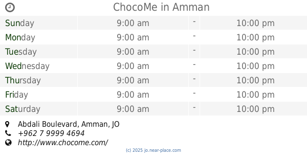
ChocoMe
Abdali Boulevard, Amman
Food
read more
2.328 km
Hashem Affouri Sweets Amman
Al, Rainbow Street, Amman
Food
read more
2.329 km
afternoon
Al-Rainbow Street, Amman
Food
read more
2.345 km
Tulip International Trading Est.
Issam Al Ajlouni St. 63، Tulip Complex، Amman, Jordan
Food
read more
2.418 km
Batateekh The Boulevard
Abdali Boulevard, Amman
Food
read more
2.512 km
Tamryet Omar
Al-Kulliyah Al-Elmeyah Al-Islameyah Street 55, Amman
Food
read more
2.732 km
Izhiman Coffee بن ازحيمان
31°59'18.8"N 35°52'00.0"E 31.988567, 35.866677, Amman
Food
read more
3.075 km
سوبرمارك صالح
Amman
Food
read more
3.466 km
Al-abdallat Ocaison Planner العبداللات للاحتفالات
Amman
Food
read more
📑
all categories
Accounting
Administrative area level 1
Administrative area level 2
Airport
Amusement park
Aquarium
Art gallery
Atm
Bakery
Bank
Bar
Beauty salon
Bicycle store
Book store
Bowling alley
Bus station
Cafe
Campground
Car dealer
Car rental
Car repair
Car wash
Cemetery
Church
City hall
Clothing store
Colloquial area
Convenience store
Country
Courthouse
Dentist
Department store
Doctor
Electrician
Electronics store
Embassy
Finance
Fire station
Florist
Food
Funeral home
Furniture store
Gas station
General contractor
Grocery or supermarket
Gym
Hair care
Hardware store
Health
Home goods store
Hospital
Insurance agency
Jewelry store
Laundry
Lawyer
Library
Liquor store
Local government office
Locality
Locksmith
Lodging
Meal delivery
Meal takeaway
Mosque
Movie rental
Movie theater
Moving company
Museum
Natural feature
Neighborhood
Night club
Painter
Park
Parking
Pet store
Pharmacy
Physiotherapist
Place of worship
Plumber
Point of interest
Police
Post office
Premise
Real estate agency
Restaurant
Route
Rv park, camping
School
Shoe store
Shopping mall
Spa
Stadium
Storage
Store
Supermarket
Taxi stand
Train station
Travel agency
University
Veterinary care
Zoo
sublocality level 1
↑