Doctor nearby عيادات الكريمة الطبية
Jordan
Doctor nearby عيادات الكريمة الطبية
عيادات الكريمة الطبية
Irbid Governorate, Иордания
contacts phone
:
+962 7 8123 3576
Latitude:
32.3031017
, Longitude:
35.5862986
larger map & directions
read more
nearest Doctor
149 m
الدكتور بلال الشويات
الاغوار الشماليه ،، كريمة،
Doctor
read more
3.102 km
عيادة د عامر البلاونة
Kuraymah
Doctor
read more
3.724 km
مركز صحي الكريمة وكالة الغوث
Ajloun
Doctor
read more
5.909 km
Health Center Alohadnp
Khirbat al Wahadinah
Doctor
read more
15.992 km
Health center sub Achtvina
Ajloun
Doctor
read more
20.466 km
عيادة ربوع العارضه
As-Subayhi
Doctor
read more
20.723 km
عياده اسنان
Doctor
read more
20.731 km
عيادة الدكتور يزيد
Salt Ring Road, As-Salt
Doctor
read more
20.959 km
مكز صحي ساكب
Jerash
Doctor
read more
21.03 km
جسر الشيخ حسين
Doctor
read more
21.61 km
مركز الشرق للخدمات البيطريه
Doctor
read more
24.423 km
Medical Clinics Naima
Arhaba
Doctor
read more
34.273 km
عيادة الحصن الطبية
شارع الملك طلال بجانب موقف الباصات،, Al-Husun
Doctor
read more
36.481 km
Dahab Clinic
Irbid
Doctor
read more
46.901 km
Dr.nedal Alja'bari
Amman
Doctor
read more
47.484 km
Advanced Medical Industries AMI (Baxter - Gambro)
Amman
Doctor
read more
47.564 km
د.بهاء نمر
شارع الاستقلال, Amman
Doctor
read more
48.122 km
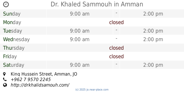
Dr. Khaled Sammouh
King Hussein Street, Amman
Doctor
read more
48.633 km
RHC Centerمركز الرائد للقلب
Al-Mutanabbi Street, Amman
Doctor
read more
48.754 km
Dr. Raid Marji Clinic
Ibn Khaldoun Street, Amman
Doctor
read more
48.955 km
عيادة الدكتورة ميسون قنديل
Prince Hamzah Ben Al-Hussein Street, Amman
Doctor
read more
51.545 km
المركز الطبي الاسلامي
Amman
Doctor
read more
53.095 km
العيادات التخصصيه الحديثه
الأمير الحسن،، عمّان
Doctor
read more
54.911 km
zarka camp health center -unrwa
Az-Zarqa
Doctor
read more
62.138 km
مركز ديمومة للاعشاب
Sahab Street, Amman
Doctor
read more
📑
all categories
Accounting
Administrative area level 1
Administrative area level 2
Airport
Amusement park
Aquarium
Art gallery
Atm
Bakery
Bank
Bar
Beauty salon
Bicycle store
Book store
Bowling alley
Bus station
Cafe
Campground
Car dealer
Car rental
Car repair
Car wash
Cemetery
Church
City hall
Clothing store
Colloquial area
Convenience store
Country
Courthouse
Dentist
Department store
Doctor
Electrician
Electronics store
Embassy
Finance
Fire station
Florist
Food
Funeral home
Furniture store
Gas station
General contractor
Grocery or supermarket
Gym
Hair care
Hardware store
Health
Home goods store
Hospital
Insurance agency
Jewelry store
Laundry
Lawyer
Library
Liquor store
Local government office
Locality
Locksmith
Lodging
Meal delivery
Meal takeaway
Mosque
Movie rental
Movie theater
Moving company
Museum
Natural feature
Neighborhood
Night club
Painter
Park
Parking
Pet store
Pharmacy
Physiotherapist
Place of worship
Plumber
Point of interest
Police
Post office
Premise
Real estate agency
Restaurant
Route
Rv park, camping
School
Shoe store
Shopping mall
Spa
Stadium
Storage
Store
Supermarket
Taxi stand
Train station
Travel agency
University
Veterinary care
Zoo
sublocality level 1
↑