Cemetery nearby North Amman Cemetery
Jordan
Cemetery nearby North Amman Cemetery
North Amman Cemetery
Шафа Бадран, Амман, Иордания
contacts phone
:
+962
Latitude:
32.04056
, Longitude:
35.961029
larger map & directions
read more
nearest Cemetery
3.284 km
مقبرة ابو عليا
Amman
Cemetery
read more
3.284 km
مقبره ابو عليا
Amman
Cemetery
read more
4.861 km
مقبرة شفابدران - Shafa Badran Cemetry
Amman
Cemetery
read more
5.585 km
Hittin camp cemetery
Russayfah
Cemetery
read more
5.604 km
مقبرة المخيم
Russayfah
Cemetery
read more
5.608 km
Camp Cemetery المقبرة
Russayfah
Cemetery
read more
6.797 km
Marca cemetery
Amman
Cemetery
read more
7.719 km
Alrowwad Stone
Haroun Ar-Rashid Street, Amman
Cemetery
read more
8.351 km
Muslim Cemetery
Amman
Cemetery
read more
8.483 km
Al Hashimi Cemetery
Al Taqwa, Amman
Cemetery
read more
8.824 km
Strong Power Stone SPS
Al Amal Complex, Nablus St 105, Amman
Cemetery
read more
9.885 km
مقبرة حي عدن
Amman
Cemetery
read more
10.812 km
مقبرة
Cemetery
read more
11.184 km
مقبرة حي الجندي
Az-Zarqa
Cemetery
read more
11.637 km
مقبرة الشيشان
Amman
Cemetery
read more
11.654 km
مقبرة Cemetery
Al Nathif, Amman
Cemetery
read more
11.677 km
Baqa'a Second Cemetery
البقعة
Cemetery
read more
11.822 km
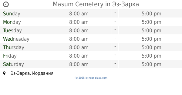
Masum Cemetery
Az-Zarqa
Cemetery
read more
12.211 km
Shawwam Cemetery
Az-Zarqa
Cemetery
read more
12.287 km
مقبرة مخيم الزرقاء
Az-Zarqa
Cemetery
read more
12.323 km
مقبرة صويلح
Mehrez Ben Nadla Street, Amman
Cemetery
read more
12.786 km
مقبرة المسيحيه
32°04'09. 36°05'32.7"E, 2nd Circle, Amman
Cemetery
read more
14.18 km
Umm al Hiran Christian Cemetery
Prince Hasan Street, Amman
Cemetery
read more
17.904 km
Star Cemetery
Cemetery
read more
19.57 km
مقبرة أم عبهره
Amman
Cemetery
read more
📑
all categories
Accounting
Administrative area level 1
Administrative area level 2
Airport
Amusement park
Aquarium
Art gallery
Atm
Bakery
Bank
Bar
Beauty salon
Bicycle store
Book store
Bowling alley
Bus station
Cafe
Campground
Car dealer
Car rental
Car repair
Car wash
Cemetery
Church
City hall
Clothing store
Colloquial area
Convenience store
Country
Courthouse
Dentist
Department store
Doctor
Electrician
Electronics store
Embassy
Finance
Fire station
Florist
Food
Funeral home
Furniture store
Gas station
General contractor
Grocery or supermarket
Gym
Hair care
Hardware store
Health
Home goods store
Hospital
Insurance agency
Jewelry store
Laundry
Lawyer
Library
Liquor store
Local government office
Locality
Locksmith
Lodging
Meal delivery
Meal takeaway
Mosque
Movie rental
Movie theater
Moving company
Museum
Natural feature
Neighborhood
Night club
Painter
Park
Parking
Pet store
Pharmacy
Physiotherapist
Place of worship
Plumber
Point of interest
Police
Post office
Premise
Real estate agency
Restaurant
Route
Rv park, camping
School
Shoe store
Shopping mall
Spa
Stadium
Storage
Store
Supermarket
Taxi stand
Train station
Travel agency
University
Veterinary care
Zoo
sublocality level 1
↑