Cafe nearby Zodiac Cafe & Restaurant
Jordan
Cafe nearby Zodiac Cafe & Restaurant
Zodiac Cafe & Restaurant
4, Faeq Haddadin St, Amman, JO ירדן
contacts phone
:
+962 6 551 3344
Latitude:
31.9765877
, Longitude:
35.8649701
larger map & directions
read more
nearest Cafe
92 m
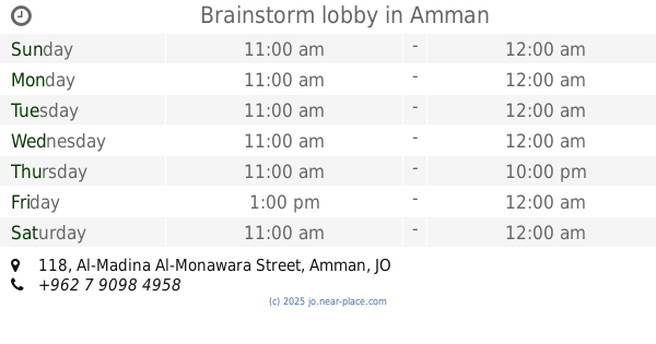
Brainstorm lobby
Al-Madina Al-Monawara Street 118, Amman
Cafe
read more
109 m
Ahwet Al Madam
Orwa Ben Odhaynah Street, Amman
Cafe
read more
141 m
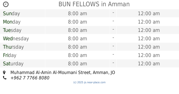
BUN FELLOWS
Muhammad Al-Amin Al-Moumani Street, Amman
Cafe
read more
171 m
Goa Cafe
Prime Center, Street Zhr 13, Amman
Cafe
read more
171 m
Brewed Coffee JO
Muhammad Al-Amin Al-Moumani Street, Amman
Cafe
read more
177 m
Puna Kaife
Amman
Cafe
read more
380 m
Doors Cafe Mecca Street
Amman
Cafe
read more
483 m
A'Kaifak Cafe & Restaurant ع كيفك
15, Amman
Cafe
read more
504 m
Cafe Social
Complex No 111, Mecca Al Mukarramah St 111, Amman
Cafe
read more
520 m
Funjan Cafe
Amman
Cafe
read more
622 m
rocca Hookah & Lounge
Madina Monawarah Street
Cafe
read more
634 m
Pastiche Cafe
15, Amman
Cafe
read more
691 m
Bel Mondo Cafe
Bel Mondo Cafe, Mecca Al Mukarramah St 101, Amman
Cafe
read more
694 m
Bel Mondo
15, Amman
Cafe
read more
718 m
Cafe Najjar
King Faysal Bin Abdulazeez Street, Amman
Cafe
read more
759 m
Ta3leleh Cafe
Amman
Cafe
read more
763 m
منتدى الرواد الكبار
Ar-Rihaniyah Street, Amman
Cafe
read more
836 m
Lavazza
Amman
Cafe
read more
860 m
Sedra
Amman
Cafe
read more
930 m
Mixdo
Al-Madina Al-Monawara Street 168, Amman
Cafe
read more
956 m
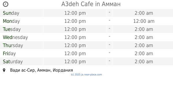
A3deh Cafe
Amman
Cafe
read more
1.004 km
Sillam study center
Princess Rahmah Bent Al-Hasan Street, Amman
Cafe
read more
1.158 km
Abu Wadee Al Gharabli Cafeteria
Shehadeh Mahmoud Salameh Complex, Princess Rahma El Hassan St 49, Amman
Cafe
read more
1.27 km
Ahwet Abdeen أهوة عابدين
Abdallah Ghosheh Street, Amman
Cafe
read more
1.331 km
كهوة كال وكلنا
Abdallah Ghosheh Street, Amman
Cafe
read more
📑
all categories
Accounting
Administrative area level 1
Administrative area level 2
Airport
Amusement park
Aquarium
Art gallery
Atm
Bakery
Bank
Bar
Beauty salon
Bicycle store
Book store
Bowling alley
Bus station
Cafe
Campground
Car dealer
Car rental
Car repair
Car wash
Cemetery
Church
City hall
Clothing store
Colloquial area
Convenience store
Country
Courthouse
Dentist
Department store
Doctor
Electrician
Electronics store
Embassy
Finance
Fire station
Florist
Food
Funeral home
Furniture store
Gas station
General contractor
Grocery or supermarket
Gym
Hair care
Hardware store
Health
Home goods store
Hospital
Insurance agency
Jewelry store
Laundry
Lawyer
Library
Liquor store
Local government office
Locality
Locksmith
Lodging
Meal delivery
Meal takeaway
Mosque
Movie rental
Movie theater
Moving company
Museum
Natural feature
Neighborhood
Night club
Painter
Park
Parking
Pet store
Pharmacy
Physiotherapist
Place of worship
Plumber
Point of interest
Police
Post office
Premise
Real estate agency
Restaurant
Route
Rv park, camping
School
Shoe store
Shopping mall
Spa
Stadium
Storage
Store
Supermarket
Taxi stand
Train station
Travel agency
University
Veterinary care
Zoo
sublocality level 1
↑