Cafe nearby TcheTche Cafe
Jordan
Cafe nearby TcheTche Cafe
TcheTche Cafe
544, Queen Alia Airport St, Amman, JO ירדן
contacts phone
:
+962 6 429 0307
website:
www.tchetchecafe.com
Latitude:
31.843218
, Longitude:
35.881436
larger map & directions
read more
nearest Cafe
822 m
Qais Espresso & More Cafe
Queen Alia Airport Road 568, Amman
Cafe
read more
2.554 km
منتزه نبع العراد
Amman
Cafe
read more
2.939 km
مقهى ودكان دارة
mahmoud alshref Road, Amman
Cafe
read more
3.573 km
Coffee Barhoma
No 288 288, Maadaba Al Gharbi, Amman
Cafe
read more
3.641 km
قعدة عرب كافيه
قباء،, Amman
Cafe
read more
3.806 km
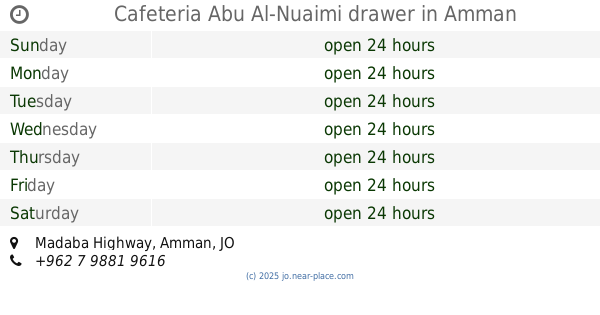
Cafeteria Abu Al-Nuaimi drawer
Madaba Highway, Amman
Cafe
read more
4.086 km
ابو شقرة
Anissa Bent Helal Street, Amman
Cafe
read more
4.574 km
مقهى هوا عمان
جاوا الجنوبي،, Amman
Cafe
read more
4.675 km
Al Barkah Cafe
Amman
Cafe
read more
4.699 km
قهوة كتكت
الاندلس،, Amman
Cafe
read more
4.884 km
كوفي شوب الأصيل Alassil cafe
Amman
Cafe
read more
5.096 km
Cafe painter
Amman
Cafe
read more
5.1 km
نادي ومقهى ليث الشرفا
Jawa Street, Amman
Cafe
read more
5.124 km
Coffee Word
Amman
Cafe
read more
5.144 km
مقهى الترس
Amman
Cafe
read more
5.166 km
قهوة المختار
Amman
Cafe
read more
5.176 km
Coffee Khaled Salti
خريبة السوق, Amman
Cafe
read more
5.184 km
Wifi Cafe ( Playstation And Game Center )
Kasseb Al-Jazi Street 17, Amman
Cafe
read more
5.318 km
قهوة ابو حابس
Amman
Cafe
read more
5.445 km
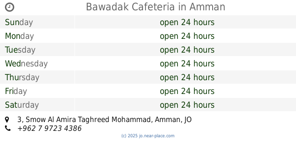
Bawadak Cafeteria
Complex No 3, Smow Al Amira Taghreed Mohammad 3, Amman
Cafe
read more
5.665 km
classico playstation club and cafe
Princess Taghreed Mohammad Street, Amman
Cafe
read more
5.896 km
Prince of the Aragel
Al Taibah & Kherbet Al Souq، عمّان
Cafe
read more
5.949 km
Al Moshakes Cafeteria
Complex No 97, Madaba St 97, Amman
Cafe
read more
5.986 km
كافتيريا ابو صيام
Amman
Cafe
read more
6.19 km
كفتيريا حبوش
Hizam Ring Road, Amman
Cafe
read more
📑
all categories
Accounting
Administrative area level 1
Administrative area level 2
Airport
Amusement park
Aquarium
Art gallery
Atm
Bakery
Bank
Bar
Beauty salon
Bicycle store
Book store
Bowling alley
Bus station
Cafe
Campground
Car dealer
Car rental
Car repair
Car wash
Cemetery
Church
City hall
Clothing store
Colloquial area
Convenience store
Country
Courthouse
Dentist
Department store
Doctor
Electrician
Electronics store
Embassy
Finance
Fire station
Florist
Food
Funeral home
Furniture store
Gas station
General contractor
Grocery or supermarket
Gym
Hair care
Hardware store
Health
Home goods store
Hospital
Insurance agency
Jewelry store
Laundry
Lawyer
Library
Liquor store
Local government office
Locality
Locksmith
Lodging
Meal delivery
Meal takeaway
Mosque
Movie rental
Movie theater
Moving company
Museum
Natural feature
Neighborhood
Night club
Painter
Park
Parking
Pet store
Pharmacy
Physiotherapist
Place of worship
Plumber
Point of interest
Police
Post office
Premise
Real estate agency
Restaurant
Route
Rv park, camping
School
Shoe store
Shopping mall
Spa
Stadium
Storage
Store
Supermarket
Taxi stand
Train station
Travel agency
University
Veterinary care
Zoo
sublocality level 1
↑