Cafe nearby قهوة الوقاد
Coronavirus disease (COVID-19) Situation
confirmed cases
1746997
deaths
14122
Jordan
Cafe nearby قهوة الوقاد
قهوة الوقاد
الاخضر،، Amman, Иордания
contacts phone
:
+962 7 9642 0222
Latitude:
31.9276059
, Longitude:
35.9037649
larger map & directions
read more
nearest Cafe
17 m
قهوة العبادي
An-Nabeghah Al-Jaadi Street, Amman
Cafe
read more
99 m
FUN NETWORK GAMES
Amman
Cafe
read more
384 m
Mazzika Cafe مزيكا كافيه
Amman
Cafe
read more
436 m
Cafe Ps4 Elyasmeem
Al-Shura Street 34, Amman
Cafe
read more
562 m
Kiswani Coffee
Al Thra', Amman
Cafe
read more
658 m
Arzaq financial solution
Amman
Cafe
read more
710 m
كافتيريا المسافة
Al-Shura Street, Amman
Cafe
read more
891 m
كافيه دموع الورد
Amman
Cafe
read more
1.135 km
Fakhoury Cafeteria
Complex No 260, Prince Hashem Bin Al Hussein St 260, Amman
Cafe
read more
1.268 km
قهوة مريزيق
Prince Ali Ben Al-Hussein Street, Amman
Cafe
read more
1.269 km
Abu Helweh Coffee
Al Yasmeen Medical Complex, Jabal Arafat Street 5, Amman
Cafe
read more
1.41 km
Jad & Azad Cafe
Amman
Cafe
read more
1.437 km
Study Corner
الياسمين،, Amman
Cafe
read more
1.545 km
مقهى ابو صالح
Amman
Cafe
read more
1.607 km
Ver Amman
Irbid Street 2, Amman
Cafe
read more
1.652 km
كافيه نفس
ش. جبل عرفات،, Amman
Cafe
read more
1.783 km
بول شارك Pool shark
As-Sakhrah Al-Musharrafah Street 146،, Amman
Cafe
read more
2.059 km
قهوة أبو زايد أحمد
Ad-Dustour Street 29, Amman
Cafe
read more
2.093 km
Juicebangbang
#72 Pr. Hashim St, TAJ Mall, Amman
Cafe
read more
2.097 km
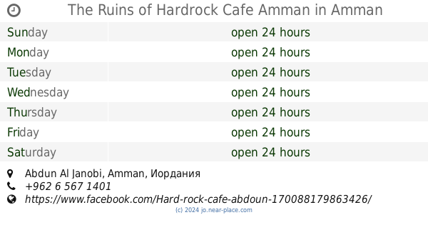
The Ruins of Hardrock Cafe Amman
Abdun Al Janobi, Amman
Cafe
read more
2.114 km
Nestle Cafe - Taj Mall - Jordan
Taj Mall, Abdoun
Cafe
read more
2.151 km
STARBUCKS COFFEE
Taj Mall, Amman
Cafe
read more
2.177 km
The Café Gourmand - Taj Lifestyle
Saed Abdo Shammout Street, Amman
Cafe
read more
2.29 km
Cafe mai7ana ميحانه
Amman
Cafe
read more
2.596 km
Jonia Cafe'
Amman
Cafe
read more
📑
all categories
Accounting
Administrative area level 1
Administrative area level 2
Airport
Amusement park
Aquarium
Art gallery
Atm
Bakery
Bank
Bar
Beauty salon
Bicycle store
Book store
Bowling alley
Bus station
Cafe
Campground
Car dealer
Car rental
Car repair
Car wash
Cemetery
Church
City hall
Clothing store
Colloquial area
Convenience store
Country
Courthouse
Dentist
Department store
Doctor
Electrician
Electronics store
Embassy
Finance
Fire station
Florist
Food
Funeral home
Furniture store
Gas station
General contractor
Grocery or supermarket
Gym
Hair care
Hardware store
Health
Home goods store
Hospital
Insurance agency
Jewelry store
Laundry
Lawyer
Library
Liquor store
Local government office
Locality
Locksmith
Lodging
Meal delivery
Meal takeaway
Mosque
Movie rental
Movie theater
Moving company
Museum
Natural feature
Neighborhood
Night club
Painter
Park
Parking
Pet store
Pharmacy
Physiotherapist
Place of worship
Plumber
Point of interest
Police
Post office
Premise
Real estate agency
Restaurant
Route
Rv park, camping
School
Shoe store
Shopping mall
Spa
Stadium
Storage
Store
Supermarket
Taxi stand
Train station
Travel agency
University
Veterinary care
Zoo
sublocality level 1
↑