Cafe nearby Nay Cafe
Jordan
Cafe nearby Nay Cafe
Nay Cafe
Al-Kulliyah Al-Elmeyah Al-Islameyah Street, Amman, JO Jordania
contacts phone
:
+962 6 465 5755
Latitude:
31.9508676
, Longitude:
35.9197294
larger map & directions
read more
nearest Cafe
294 m
Twana cafe
Al-Buhtori Street, Amman
Cafe
read more
333 m
Abu Sultan Cafe
Prince Muhammad Street, Amman
Cafe
read more
414 m
Salam Kanaan Gallery
Taher Al Juqqah street 100, Amman
Cafe
read more
429 m
Rasha & Hala Good Day
Prince Muhammad Street 225, Amman
Cafe
read more
501 m
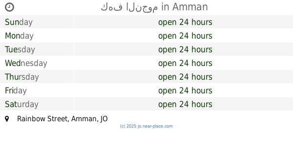
كهف النجوم
Rainbow Street, Amman
Cafe
read more
726 m
Milk and Beans
Al-Shariaah College Street 28, Amman
Cafe
read more
751 m
Taras Zaman
Amman
Cafe
read more
755 m
Jara Cafe
Al-Rainbow Street, Amman
Cafe
read more
762 m
مطعم و كافية البلده القديمة
Al-Shariaah College Street, Amman
Cafe
read more
782 m
Hade dondurma coffe bar
Amman
Cafe
read more
785 m
Korba cafe
Al-Farazdaq Street, Amman
Cafe
read more
785 m
Qerfeh قرفة
Amman
Cafe
read more
824 m
Rumi Cafe
Ash Shariaah College, Amman
Cafe
read more
852 m
Aristotle Cafe أرسطو كافيه
Al-Farazdaq Street, Amman
Cafe
read more
865 m
Cafe Abu Sultan
Prince Muhammad Street, Amman
Cafe
read more
874 m
Rihhan Cafe
Amman
Cafe
read more
875 m
مقهى ريحان
Jarir Street, Amman
Cafe
read more
884 m
Awtad اوتاد
Amman
Cafe
read more
896 m
Tallet Al Waibdeh
Amman
Cafe
read more
916 m
Salam Kanaan Gallery
24 Rainbow Street
Cafe
read more
920 m
Ahwet El Khedewy
Complex No 276, Prince Mohammad St 276, Amman
Cafe
read more
932 m
مقهى الأردن
Amman
Cafe
read more
954 m
Hareem Al Sultan Restaurant & Cafe
Complex No 3, Moh'd Al Shareebi St 3, Amman
Cafe
read more
1.005 km
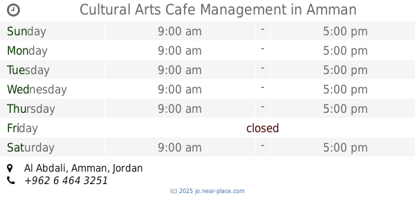
Cultural Arts Cafe Management
Amman
Cafe
read more
1.029 km
Bait Baladna بيت بلدنا
Nadim Al-Mallah Street 21, Amman
Cafe
read more
📑
all categories
Accounting
Administrative area level 1
Administrative area level 2
Airport
Amusement park
Aquarium
Art gallery
Atm
Bakery
Bank
Bar
Beauty salon
Bicycle store
Book store
Bowling alley
Bus station
Cafe
Campground
Car dealer
Car rental
Car repair
Car wash
Cemetery
Church
City hall
Clothing store
Colloquial area
Convenience store
Country
Courthouse
Dentist
Department store
Doctor
Electrician
Electronics store
Embassy
Finance
Fire station
Florist
Food
Funeral home
Furniture store
Gas station
General contractor
Grocery or supermarket
Gym
Hair care
Hardware store
Health
Home goods store
Hospital
Insurance agency
Jewelry store
Laundry
Lawyer
Library
Liquor store
Local government office
Locality
Locksmith
Lodging
Meal delivery
Meal takeaway
Mosque
Movie rental
Movie theater
Moving company
Museum
Natural feature
Neighborhood
Night club
Painter
Park
Parking
Pet store
Pharmacy
Physiotherapist
Place of worship
Plumber
Point of interest
Police
Post office
Premise
Real estate agency
Restaurant
Route
Rv park, camping
School
Shoe store
Shopping mall
Spa
Stadium
Storage
Store
Supermarket
Taxi stand
Train station
Travel agency
University
Veterinary care
Zoo
sublocality level 1
↑