Bakery nearby معجنات الأيام الشامية
Jordan
Bakery nearby معجنات الأيام الشامية
معجنات الأيام الشامية
Amman Israel
contacts phone
:
+962
Latitude:
31.9083171
, Longitude:
35.9377766
read more
nearest Bakery
22 m
Hetten Bakeries
شارع عبدالله إبن سلام, Amman
Bakery
read more
634 m
مخابز الهندي الالية
Amman
Bakery
read more
649 m
مخبز تيم
Amman
Bakery
read more
1.21 km
مخابز وحلويات محمد الجمال
شارع سلامة الرجا الحويان, Amman
Bakery
read more
1.355 km
حلويات العنبتاوي فرع القويسمة
Complex No 26, Menwer Al Hadeed St 26, Amman
Bakery
read more
1.368 km
مخبز الجمال
Amman
Bakery
read more
1.372 km
Bakeries International Samara
Amman
Bakery
read more
1.86 km
مخابز الصحابة
Amman
Bakery
read more
1.932 km
مخابز الصادق
Amman
Bakery
read more
1.947 km
jeeran cake جيران كيك
Amman
Bakery
read more
2.417 km
Sponge Cake
Complex No 58, Luqman St 58, Amman
Bakery
read more
2.465 km
مخبز تيم
Aishah At-Taymoureyah Street, Amman
Bakery
read more
2.534 km
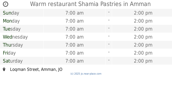
Warm restaurant Shamia Pastries
Loqman Street, Amman
Bakery
read more
2.579 km
مخبز الساخن
Amman
Bakery
read more
2.62 km
مخابز ابو بكر
Amman
Bakery
read more
2.651 km
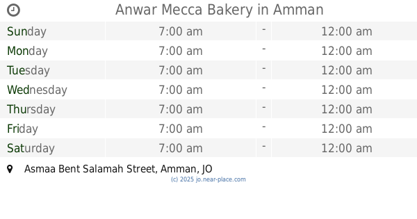
Anwar Mecca Bakery
Asmaa Bent Salamah Street, Amman
Bakery
read more
2.683 km
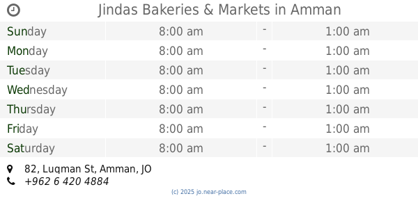
Jindas Bakeries & Markets
Complex No 82, Luqman St 82, Amman
Bakery
read more
2.718 km
مخبز الريحان
Amman
Bakery
read more
2.778 km
Al Taawon Bakery
Complex No 31, Besher Bin Al Baraa St 31, Amman
Bakery
read more
2.797 km
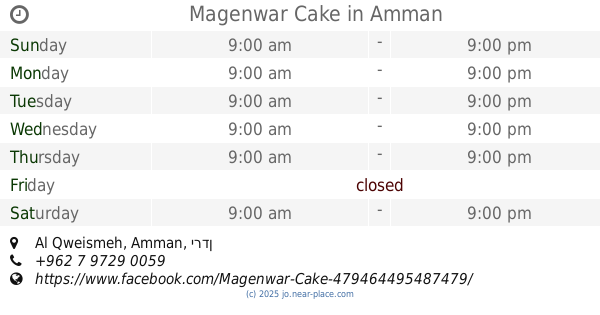
Magenwar Cake
Amman
Bakery
read more
2.962 km
Lecce Cake
31°54'16.3"N 35°58'07., 8th Circle, Amman
Bakery
read more
3.055 km
Abella Automatic Bakeries
Al-Yarmouk Street 304, Amman
Bakery
read more
3.247 km
Bakery Alalcomiah / Tabon
Amman
Bakery
read more
3.591 km
مخابز برجوس
Amman
Bakery
read more
3.974 km
Al Nush Bakery
Amman
Bakery
read more
📑
all categories
Accounting
Administrative area level 1
Administrative area level 2
Airport
Amusement park
Aquarium
Art gallery
Atm
Bakery
Bank
Bar
Beauty salon
Bicycle store
Book store
Bowling alley
Bus station
Cafe
Campground
Car dealer
Car rental
Car repair
Car wash
Cemetery
Church
City hall
Clothing store
Colloquial area
Convenience store
Country
Courthouse
Dentist
Department store
Doctor
Electrician
Electronics store
Embassy
Finance
Fire station
Florist
Food
Funeral home
Furniture store
Gas station
General contractor
Grocery or supermarket
Gym
Hair care
Hardware store
Health
Home goods store
Hospital
Insurance agency
Jewelry store
Laundry
Lawyer
Library
Liquor store
Local government office
Locality
Locksmith
Lodging
Meal delivery
Meal takeaway
Mosque
Movie rental
Movie theater
Moving company
Museum
Natural feature
Neighborhood
Night club
Painter
Park
Parking
Pet store
Pharmacy
Physiotherapist
Place of worship
Plumber
Point of interest
Police
Post office
Premise
Real estate agency
Restaurant
Route
Rv park, camping
School
Shoe store
Shopping mall
Spa
Stadium
Storage
Store
Supermarket
Taxi stand
Train station
Travel agency
University
Veterinary care
Zoo
sublocality level 1
↑