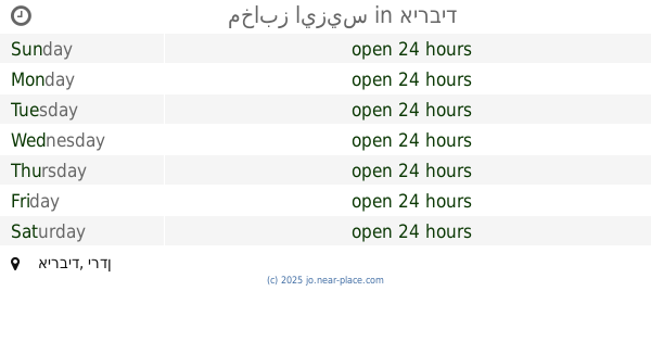
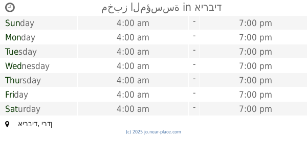
Bakery nearby Alsoata Bakery
Jordan
Bakery nearby Alsoata Bakery
Alsoata Bakery
Irbid Governorate, Иордания
contacts phone
:
+962
Latitude:
32.6512991
, Longitude:
35.693014
larger map & directions
read more
nearest Bakery
12.249 km
Jihad automated bakery
Saddam Hussein Street
Bakery
read more
12.361 km
مخبز الناجي للخبز البلدي (أبو مهنا)
Bakery
read more
12.417 km
مخبز التقوى
Bakery
read more
12.496 km
Zhr bakery
Irbid
Bakery
read more
13.224 km
Bakeries mechanism Bahrain
Bakery
read more
14.849 km
Anwar Makah Bakery
Irbid
Bakery
read more
15.361 km
مخابز الفرقان
Irbid
Bakery
read more
15.938 km
مخابز وحلويات العنان الآلية
Bakery
read more
16.587 km
مخابز ايزيس
Irbid
Bakery
read more
17.189 km
مخبز
Irbid
Bakery
read more
17.234 km
مخبز المؤسسة
Irbid
Bakery
read more
17.265 km
مخبز أنوار مكة
Abdul Hamid Sharaf Street, Irbid
Bakery
read more
17.706 km
مخبز مشروح
Irbid
Bakery
read more
17.902 km
معجنات الكردي
اربد_شارع الثلاثين، إربد،
Bakery
read more
17.939 km
مخبز الاخيار للخبز البلدي
حسبة السوق, Irbid
Bakery
read more
18.615 km
معجنات الافندي
Irbid
Bakery
read more
18.645 km
مخابز السنبلة
Irbid
Bakery
read more
18.645 km
مخابز ابو حمزة الآلية
Feras Al-Ajlouni Street, Irbid
Bakery
read more
18.863 km
المخبز البلدي
Al-Ahram Street, Irbid
Bakery
read more
18.927 km
مخبز الفوال
Irbid
Bakery
read more
19.033 km
معجنات الجامعة
Irbid
Bakery
read more
19.32 km
Al Rabeah Bakery
Irbid
Bakery
read more
19.597 km
Sweets & Bakeries Pearl Lebanon
Ar-Razi Street, Irbid
Bakery
read more
19.913 km
جوهره جمال
Shafiq Irshydat, Aydoun
Bakery
read more
20.153 km
Pastries Mecca
Bakery
read more
📑
all categories
Accounting
Administrative area level 1
Administrative area level 2
Airport
Amusement park
Aquarium
Art gallery
Atm
Bakery
Bank
Bar
Beauty salon
Bicycle store
Book store
Bowling alley
Bus station
Cafe
Campground
Car dealer
Car rental
Car repair
Car wash
Cemetery
Church
City hall
Clothing store
Colloquial area
Convenience store
Country
Courthouse
Dentist
Department store
Doctor
Electrician
Electronics store
Embassy
Finance
Fire station
Florist
Food
Funeral home
Furniture store
Gas station
General contractor
Grocery or supermarket
Gym
Hair care
Hardware store
Health
Home goods store
Hospital
Insurance agency
Jewelry store
Laundry
Lawyer
Library
Liquor store
Local government office
Locality
Locksmith
Lodging
Meal delivery
Meal takeaway
Mosque
Movie rental
Movie theater
Moving company
Museum
Natural feature
Neighborhood
Night club
Painter
Park
Parking
Pet store
Pharmacy
Physiotherapist
Place of worship
Plumber
Point of interest
Police
Post office
Premise
Real estate agency
Restaurant
Route
Rv park, camping
School
Shoe store
Shopping mall
Spa
Stadium
Storage
Store
Supermarket
Taxi stand
Train station
Travel agency
University
Veterinary care
Zoo
sublocality level 1
↑