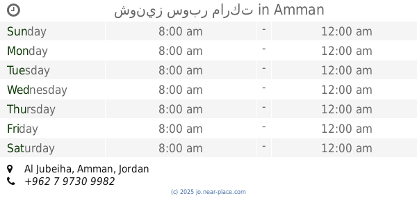
Supermarket nearby Zaid & Fares Supermarket
Jordan
Supermarket nearby Zaid & Fares Supermarket
Zaid & Fares Supermarket
Al-Dżubajha, Amman, Jordania
contacts phone
:
+962
Latitude:
32.0231452
, Longitude:
35.8668416
larger map & directions
read more
nearest Supermarket
133 m
مياه كستنا
Abdallah Ali Al-Lawzi Street, Amman
Supermarket
read more
196 m
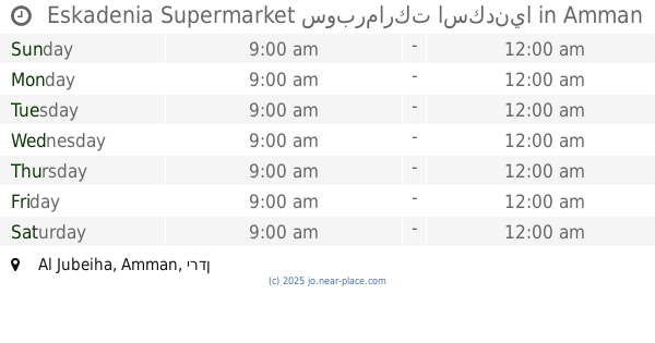
Eskadenia Supermarket سوبرماركت اسكدنيا
Amman
Supermarket
read more
299 m
حي البلدية ميني ماركت
Al Baladiyah, Amman
Supermarket
read more
299 m
حي البلدية ميني ماركت
Amman
Supermarket
read more
644 m
Carrefour
Yajouz Road, Amman
Supermarket
read more
789 m
Al-Rajebi Commercial markets
Amman
Supermarket
read more
800 m
Manhal Supermarket
الجبيهه دوار المنهل
Supermarket
read more
859 m
Safeway
Yajuz, Amman
Supermarket
read more
889 m
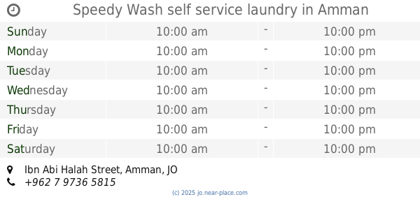
Speedy Wash self service laundry
Ibn Abi Halah Street, Amman
Supermarket
read more
911 m
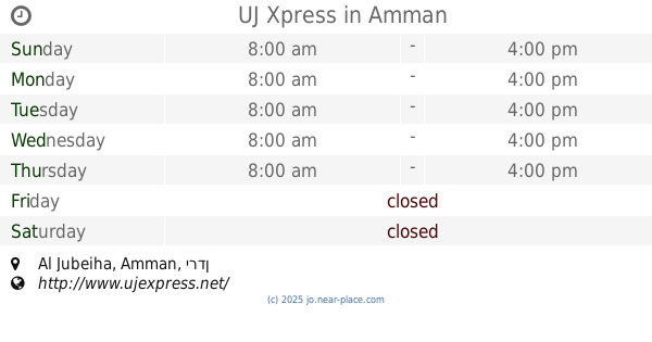
UJ Xpress
Amman
Supermarket
read more
944 m
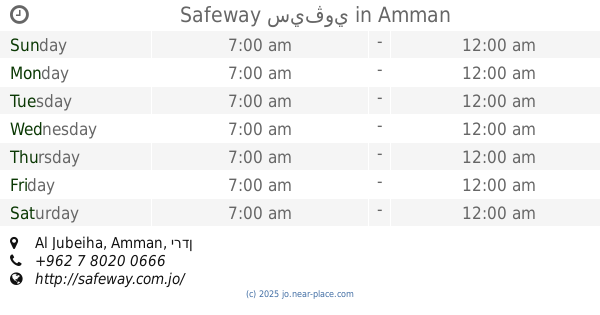
Safeway سيڤوي
Amman
Supermarket
read more
1.112 km
Anas Supermarket
Tibnah Street, Amman
Supermarket
read more
1.24 km
The Village
Amman
Supermarket
read more
1.272 km
Supermarket Altroyhh
Amman
Supermarket
read more
1.402 km
Jawharet Al Jubeiha Supermarket
Complex No 3, Wahran St 3, Amman
Supermarket
read more
1.472 km
Sky سوبر ماركت
Amman
Supermarket
read more
1.498 km
Sweileh corner grocery
Amman
Supermarket
read more
1.499 km
T&A
Khalil As-Saket Street 44،, Amman
Supermarket
read more
1.505 km
511 MAll
tlaa alaly uhod street, Amman
Supermarket
read more
1.513 km
12
Amman
Supermarket
read more
1.765 km
Abu Jamal supermarket
Amman
Supermarket
read more
1.807 km
شونيز سوبر ماركت
Amman
Supermarket
read more
1.873 km
Taleb Supermarket
Hesham Ben Al-A'as Street, Amman
Supermarket
read more
1.878 km
خرابيش محل
Salman Al-Kayed Street, Amman
Supermarket
read more
2.614 km
Rabet Moab Mini Market
Complex No 18, Al Baqourah St 18, Amman
Supermarket
read more
📑
all categories
Accounting
Administrative area level 1
Administrative area level 2
Airport
Amusement park
Aquarium
Art gallery
Atm
Bakery
Bank
Bar
Beauty salon
Bicycle store
Book store
Bowling alley
Bus station
Cafe
Campground
Car dealer
Car rental
Car repair
Car wash
Cemetery
Church
City hall
Clothing store
Colloquial area
Convenience store
Country
Courthouse
Dentist
Department store
Doctor
Electrician
Electronics store
Embassy
Finance
Fire station
Florist
Food
Funeral home
Furniture store
Gas station
General contractor
Grocery or supermarket
Gym
Hair care
Hardware store
Health
Home goods store
Hospital
Insurance agency
Jewelry store
Laundry
Lawyer
Library
Liquor store
Local government office
Locality
Locksmith
Lodging
Meal delivery
Meal takeaway
Mosque
Movie rental
Movie theater
Moving company
Museum
Natural feature
Neighborhood
Night club
Painter
Park
Parking
Pet store
Pharmacy
Physiotherapist
Place of worship
Plumber
Point of interest
Police
Post office
Premise
Real estate agency
Restaurant
Route
Rv park, camping
School
Shoe store
Shopping mall
Spa
Stadium
Storage
Store
Supermarket
Taxi stand
Train station
Travel agency
University
Veterinary care
Zoo
sublocality level 1
↑