Supermarket nearby Sameer SuperMarket
Coronavirus disease (COVID-19) Situation
confirmed cases
1746997
deaths
14122
Jordan
Supermarket nearby Sameer SuperMarket
Sameer SuperMarket
Ас-Сальт, Иордания
contacts phone
:
+962
Latitude:
32.0607764
, Longitude:
35.7364829
larger map & directions
read more
nearest Supermarket
949 m
Save Side Store
30, As-Salt
Supermarket
read more
1.036 km
جزيرة العجائب للهدايا
As-Salt
Supermarket
read more
1.429 km
سوبر ماركت عاصم
Salt Highway, As-Salt
Supermarket
read more
1.466 km
سوبر ماركت النشاش
As-Salt
Supermarket
read more
1.587 km
Abou Khaled Supermarket
As-Salt
Supermarket
read more
1.758 km
Raed Ashour Super Market
Prince Hamza Street, As-Salt
Supermarket
read more
1.772 km
جود البلقاء للخضار والفواكه
As, As-Salt
Supermarket
read more
1.937 km
شركه عمار العطيات
Prince Hamza Street, As-Salt
Supermarket
read more
2.696 km
معرض دانا ومسعود خريسات للمفروشات
As-Salt
Supermarket
read more
2.774 km
لواء عين الباشا
As-Salt
Supermarket
read more
2.783 km
اسواق المغاريب
الجدعة،, As-Salt
Supermarket
read more
2.998 km
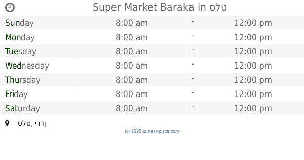
Super Market Baraka
As-Salt
Supermarket
read more
3.087 km
مركز المجد للاطارات
As-Salt
Supermarket
read more
3.41 km
Al-Hwariyoun Supermarket
As-Salt
Supermarket
read more
3.63 km
سوبر ماركت الاسرة السعيدة
As-Salt
Supermarket
read more
4.72 km
محمص المهباش السلط
30
Supermarket
read more
9.306 km
Military Consumer Establishment Ein Al Basha Branch
Supermarket
read more
10.692 km
ابو حافظ للبهارات والزعتر
30, Amman
Supermarket
read more
15.081 km
Carrefour - Al Bayader
Amman
Supermarket
read more
15.333 km
Mazen Abu Al Sondos Grocery
Complex No 70, Abd Al Rahman Al Hussami St 70, Amman
Supermarket
read more
15.552 km
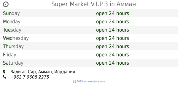
Super Market V.I.P 3
Amman
Supermarket
read more
15.864 km
Super Market Zoughair
Amman
Supermarket
read more
16.792 km
HADIL STORES
Abdullah Ben Rawahah Street 18, Amman
Supermarket
read more
16.974 km
Mollati For Dead Sea Products
Al-Hamra Street, Amman
Supermarket
read more
17.724 km
Supermarket Dora Shmeisani
Amman
Supermarket
read more
📑
all categories
Accounting
Administrative area level 1
Administrative area level 2
Airport
Amusement park
Aquarium
Art gallery
Atm
Bakery
Bank
Bar
Beauty salon
Bicycle store
Book store
Bowling alley
Bus station
Cafe
Campground
Car dealer
Car rental
Car repair
Car wash
Cemetery
Church
City hall
Clothing store
Colloquial area
Convenience store
Country
Courthouse
Dentist
Department store
Doctor
Electrician
Electronics store
Embassy
Finance
Fire station
Florist
Food
Funeral home
Furniture store
Gas station
General contractor
Grocery or supermarket
Gym
Hair care
Hardware store
Health
Home goods store
Hospital
Insurance agency
Jewelry store
Laundry
Lawyer
Library
Liquor store
Local government office
Locality
Locksmith
Lodging
Meal delivery
Meal takeaway
Mosque
Movie rental
Movie theater
Moving company
Museum
Natural feature
Neighborhood
Night club
Painter
Park
Parking
Pet store
Pharmacy
Physiotherapist
Place of worship
Plumber
Point of interest
Police
Post office
Premise
Real estate agency
Restaurant
Route
Rv park, camping
School
Shoe store
Shopping mall
Spa
Stadium
Storage
Store
Supermarket
Taxi stand
Train station
Travel agency
University
Veterinary care
Zoo
sublocality level 1
↑