Shopping mall nearby دمشقيات الزغير
Jordan
Shopping mall nearby دمشقيات الزغير
دمشقيات الزغير
Wasfi At-Tall Street, Amman, JO Иордания
contacts phone
:
+962 7 9572 3331
Latitude:
31.9837863
, Longitude:
35.8905547
larger map & directions
read more
nearest Shopping mall
81 m
زرقاء اليمامه للنظارات
Wasfi At-Tall Street, Amman
Shopping mall
read more
97 m
Shop 4 Less Supermarket
بركة،, Amman
Shopping mall
read more
162 m
Market Esal
Amman
Shopping mall
read more
168 m
ابو عابد موبايل لتجارة الاجهزة النقالة
شارع الجاردنز،، عمّان
Shopping mall
read more
169 m
Abuabedmobile
Amman
Shopping mall
read more
174 m
الاثرياء موبايل
Amman
Shopping mall
read more
312 m
فرح الجاردنز
Wasfi At-Tall Street 2, Amman
Shopping mall
read more
362 m
Asmar Jewels
Al-Sharif Naser Ben Jamil Street 92, Amman
Shopping mall
read more
366 m
Arabisk salon
Amman
Shopping mall
read more
436 m
Edmark Jordan
Amman
Shopping mall
read more
490 m
Robins Shmisani (Wadi Saqra Street)
Wadi Saqra Street, Amman
Shopping mall
read more
603 m
مجمع فهيم ليلى
Wasfi At-Tall Street 61, Amman
Shopping mall
read more
646 m
المغربي للحقائب
Amman
Shopping mall
read more
652 m
تيتانيوم موبايل
Wasfi At-Tall Street 63, Amman
Shopping mall
read more
694 m
Litchi Chocolate
Wasfi At-Tall Street 58, Amman
Shopping mall
read more
700 m
Al Mukhtar Mall
Queen Rania Street, Amman
Shopping mall
read more
708 m
Carrefour Market
Amman
Shopping mall
read more
708 m
Hakim Center for Medical Supplies
Amman
Shopping mall
read more
728 m
مجمع الفيصلية
Amman
Shopping mall
read more
884 m
mobile cozmo
Wasfi At-Tall Street 72, Amman
Shopping mall
read more
1.001 km
قدرات للتجهيزات الطبية
Hunayn Bin Ishak Street, Amman
Shopping mall
read more
1.001 km
Honey healing
Al-Shahid Road, Amman
Shopping mall
read more
1.084 km
صيدلية طيف
Al-Jahedh Street, Amman
Shopping mall
read more
1.153 km
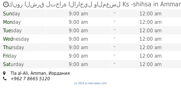
كنوز الشرق لتجارة الاراجيل والمعسل Ks -shihsa
Amman
Shopping mall
read more
1.158 km
Al Mawardy الموردي
Al Hindi Complex, Abd Al Rahman Abu Hassan St 6, Amman
Shopping mall
read more
📑
all categories
Accounting
Administrative area level 1
Administrative area level 2
Airport
Amusement park
Aquarium
Art gallery
Atm
Bakery
Bank
Bar
Beauty salon
Bicycle store
Book store
Bowling alley
Bus station
Cafe
Campground
Car dealer
Car rental
Car repair
Car wash
Cemetery
Church
City hall
Clothing store
Colloquial area
Convenience store
Country
Courthouse
Dentist
Department store
Doctor
Electrician
Electronics store
Embassy
Finance
Fire station
Florist
Food
Funeral home
Furniture store
Gas station
General contractor
Grocery or supermarket
Gym
Hair care
Hardware store
Health
Home goods store
Hospital
Insurance agency
Jewelry store
Laundry
Lawyer
Library
Liquor store
Local government office
Locality
Locksmith
Lodging
Meal delivery
Meal takeaway
Mosque
Movie rental
Movie theater
Moving company
Museum
Natural feature
Neighborhood
Night club
Painter
Park
Parking
Pet store
Pharmacy
Physiotherapist
Place of worship
Plumber
Point of interest
Police
Post office
Premise
Real estate agency
Restaurant
Route
Rv park, camping
School
Shoe store
Shopping mall
Spa
Stadium
Storage
Store
Supermarket
Taxi stand
Train station
Travel agency
University
Veterinary care
Zoo
sublocality level 1
↑