School nearby زياد سليمان الزيادنه
Jordan
School nearby زياد سليمان الزيادنه
زياد سليمان الزيادنه
Jerash, ירדן
contacts phone
:
+962 7 7009 8352
website:
roya.jo
Latitude:
32.279257
, Longitude:
35.8321211
larger map & directions
read more
nearest School
352 m
Raymond High School for Girls
Jerash
School
read more
1.026 km
مدرسة ريمون الاساسية
Jerash
School
read more
1.29 km
مدرسة نحلة الثانوية الشاملة للبنات
مدرسة نحلة الثانوية الشاملة للبنات
School
read more
1.306 km
Nahlah High school
Jerash
School
read more
2.128 km
مدرسة عيصرة المختلطة
Jerash
School
read more
2.149 km
مدرسة ساكب الاساسية للبنين
School
read more
2.217 km
Al Sabtah 2
20
School
read more
2.236 km
مدرسة الصفصافة الثانوية للبنات
Ajloun, Sakib
School
read more
2.259 km
مدرسة امنه بنت وهب
Jerash
School
read more
2.398 km
Sakib Secondary School for Girls
Sakib
School
read more
2.592 km
مدرسة ساكب الثانوية الشاملة للبنين
Jerash
School
read more
2.655 km
مدرسة اناث مخيم جرش الإعدادي الثانية الأول
Jerash
School
read more
2.749 km
SEP TAMARI Academy
Jerash
School
read more
2.758 km
Boys School Jerash camp
مخيم غزة شارع المدارس, Jerash
School
read more
2.921 km
مدرسة المرج الاساسية المختلطة
طريق جرش, Ajloun
School
read more
2.977 km
Islamic Nursary
School
read more
3.235 km
مدرسة الشيخ يوسف الاساسيه للبنين
Jerash
School
read more
3.27 km
مدرسة الحدادة الثانوية الشاملة للبنات
Jerash
School
read more
3.407 km
Moath Al Kasasbeh Mixed School
Jerash
School
read more
3.903 km
مدرسة ابواب الجنة النموذجية
Jerash
School
read more
4.769 km
مدرسة دير الليات الثانويه الشامله للبنين
Jerash
School
read more
4.791 km
مدرسة براعم العلا النموذجية
Jerash
School
read more
5.151 km
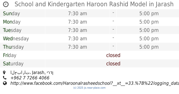
School and Kindergarten Haroon Rashid Model
الجبارات, Jerash
School
read more
5.306 km
AlHussainiat School
Ajloun
School
read more
5.569 km
Basic School for Boys Aljabbarat
Jerash
School
read more
📑
all categories
Accounting
Administrative area level 1
Administrative area level 2
Airport
Amusement park
Aquarium
Art gallery
Atm
Bakery
Bank
Bar
Beauty salon
Bicycle store
Book store
Bowling alley
Bus station
Cafe
Campground
Car dealer
Car rental
Car repair
Car wash
Cemetery
Church
City hall
Clothing store
Colloquial area
Convenience store
Country
Courthouse
Dentist
Department store
Doctor
Electrician
Electronics store
Embassy
Finance
Fire station
Florist
Food
Funeral home
Furniture store
Gas station
General contractor
Grocery or supermarket
Gym
Hair care
Hardware store
Health
Home goods store
Hospital
Insurance agency
Jewelry store
Laundry
Lawyer
Library
Liquor store
Local government office
Locality
Locksmith
Lodging
Meal delivery
Meal takeaway
Mosque
Movie rental
Movie theater
Moving company
Museum
Natural feature
Neighborhood
Night club
Painter
Park
Parking
Pet store
Pharmacy
Physiotherapist
Place of worship
Plumber
Point of interest
Police
Post office
Premise
Real estate agency
Restaurant
Route
Rv park, camping
School
Shoe store
Shopping mall
Spa
Stadium
Storage
Store
Supermarket
Taxi stand
Train station
Travel agency
University
Veterinary care
Zoo
sublocality level 1
↑