School nearby UNRWA
Jordan
School nearby UNRWA
UNRWA
Эль-Мафрак, Иордания
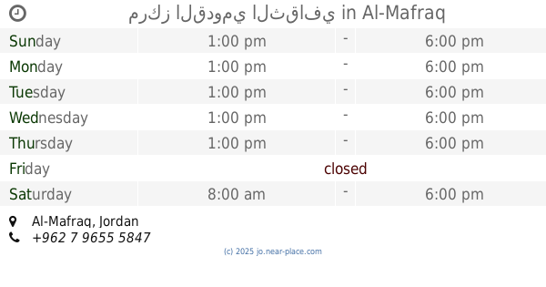
contacts phone
:
+962
Latitude:
32.3412673
, Longitude:
36.2057102
larger map & directions
read more
nearest School
100 m
Greek Catholic Kindergarten Al-Mafraq, روضة الروم الكاثوليك المفرق
Al, Al-Mafraq
School
read more
168 m
مركز القدومي الثقافي
Al-Mafraq
School
read more
219 m
Greek Catholic School Al Mafraq,
King Talal Street, Al-Mafraq
School
read more
237 m
School girl Hussein banner
Al-Mafraq
School
read more
351 m
School Prince Hussein bin Abdullah II
20, Al-Mafraq
School
read more
370 m
مدرسه الصاعدين الاسلاميه
Al-Mafraq
School
read more
492 m
مدرسة الصاعدين الاسلاميه _ الذكور
Al-Mafraq
School
read more
495 m
latin patriatrich school
Zein Al-Abdin Street, Al-Mafraq
School
read more
503 m
Abu Bakr Siddiq School Elementary Boys
Al-Mafraq
School
read more
598 m
مدرسة المفرق الثانوية الشاملة للبنات
Al-Mafraq
School
read more
643 m
Fawzi al-Mulki Secondary Boys
Al-Mafraq
School
read more
690 m
مدرسة المفرق الاساسية الثانية
Al-Mafraq
School
read more
732 m
King Abdullah II School for Excellence/Mafraq
Al-Mafraq
School
read more
741 m
Forqan Quran Center
Hamza Bin Abd-Almuttalib, Al-Mafraq
School
read more
748 m
مرسة عبدالله الثاني للتميز
Al-Mafraq
School
read more
793 m
مدرسة زيد بن حارثة الاساسية للبنين
Al-Mafraq
School
read more
809 m
مدرسة المفرق الاساسية الثانية
Al, Al-Mafraq
School
read more
842 m
مدرسة عبدالله بن رواحة
Al-Mafraq
School
read more
842 m
Almafraq second elementary boys School
Al-Mafraq
School
read more
936 m
مركز جمعية المركز الاسلامي
Al-Mafraq
School
read more
968 m
School of the House special
FaysAl-Al-Awal Street, Al-Mafraq
School
read more
981 m
مدرسة الربيع بنت المعوذ
Al-Imam Al-Shafei Street, Al-Mafraq
School
read more
1.032 km
مدرسة حي الضباط
Ash-Shuhada Street, Al-Mafraq
School
read more
1.255 km
مدرسة الحافظين الخاصة
Al-Mafraq
School
read more
1.291 km
Mafraq first Secondary School for Boys
Al-Mafraq
School
read more
📑
all categories
Accounting
Administrative area level 1
Administrative area level 2
Airport
Amusement park
Aquarium
Art gallery
Atm
Bakery
Bank
Bar
Beauty salon
Bicycle store
Book store
Bowling alley
Bus station
Cafe
Campground
Car dealer
Car rental
Car repair
Car wash
Cemetery
Church
City hall
Clothing store
Colloquial area
Convenience store
Country
Courthouse
Dentist
Department store
Doctor
Electrician
Electronics store
Embassy
Finance
Fire station
Florist
Food
Funeral home
Furniture store
Gas station
General contractor
Grocery or supermarket
Gym
Hair care
Hardware store
Health
Home goods store
Hospital
Insurance agency
Jewelry store
Laundry
Lawyer
Library
Liquor store
Local government office
Locality
Locksmith
Lodging
Meal delivery
Meal takeaway
Mosque
Movie rental
Movie theater
Moving company
Museum
Natural feature
Neighborhood
Night club
Painter
Park
Parking
Pet store
Pharmacy
Physiotherapist
Place of worship
Plumber
Point of interest
Police
Post office
Premise
Real estate agency
Restaurant
Route
Rv park, camping
School
Shoe store
Shopping mall
Spa
Stadium
Storage
Store
Supermarket
Taxi stand
Train station
Travel agency
University
Veterinary care
Zoo
sublocality level 1
↑