School nearby School Hamama basic
Jordan
School nearby School Hamama basic
School Hamama basic
מפרק, ירדן
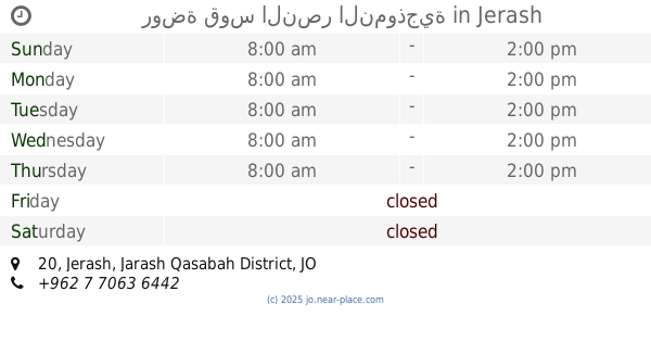
contacts phone
:
+962
Latitude:
32.3168684
, Longitude:
36.0354184
larger map & directions
read more
nearest School
2.673 km
Elementary School Diwaniya mixed
School
read more
2.791 km
مدرسة بويضة العليمات الاساسية المختلطة
20, Rihab
School
read more
3.233 km
مدرسة الدجنية الثانوية للبنين
الدجنية
School
read more
3.774 km
School Girls Secondary Dignah
School
read more
4.014 km
مدرسة رحاب الحي الشمالي الاساسية المختلطة
20, Rihab
School
read more
4.116 km
مدرسة الدقمسه الاساسيه للبنين
School
read more
4.308 km
مدرسه بويضة العليمات الاساسية
School
read more
5.149 km
مدرسة عبد الله بن الزبير الاساسية للبنبن
School
read more
6.447 km
مدرسة المعمرية الاساسية المختلطة
School
read more
7.756 km
School Manshyet Bani Hassan basic Almokhttalh
School
read more
9.249 km
مدرسة قفقفا الثانوية للبنين
Jerash
School
read more
9.545 km
مدرسة جبا الاساسية للبنات
Jerash
School
read more
9.686 km
مدرسة بلعما الحي الشمالي الاساسية المختلطة
25
School
read more
10.104 km
مدرسة علي بن ابي طالب الاساسية
Jerash
School
read more
10.488 km
مدرسة بلعما الاساسية للبنين
25
School
read more
14.161 km
مدرسة خالد بن الوليد الثانوية للبنين - كفرخل
School
read more
14.4 km
Zen Secondary School for Boys
School
read more
14.508 km
روضة قوس النصر النموذجية
20, Jerash
School
read more
14.703 km
Jerash Secondary School for Boys
Jerash
School
read more
14.919 km
Kefir School Jerash Governorate
Jerash
School
read more
15.692 km
Basic School for Boys Aljabbarat
Jerash
School
read more
15.772 km
مدرسة الظاهرية الاساسية المختلطة
المفرق بلعما, Znaya
School
read more
15.923 km
مدرسة حوشا الثانوية للبنين
Hawshah
School
read more
16.471 km
Naemeh Secondary Comprehensive School for Girls
An-Nuayyimah
School
read more
17.938 km
A fourth school Altip basic
School
read more
📑
all categories
Accounting
Administrative area level 1
Administrative area level 2
Airport
Amusement park
Aquarium
Art gallery
Atm
Bakery
Bank
Bar
Beauty salon
Bicycle store
Book store
Bowling alley
Bus station
Cafe
Campground
Car dealer
Car rental
Car repair
Car wash
Cemetery
Church
City hall
Clothing store
Colloquial area
Convenience store
Country
Courthouse
Dentist
Department store
Doctor
Electrician
Electronics store
Embassy
Finance
Fire station
Florist
Food
Funeral home
Furniture store
Gas station
General contractor
Grocery or supermarket
Gym
Hair care
Hardware store
Health
Home goods store
Hospital
Insurance agency
Jewelry store
Laundry
Lawyer
Library
Liquor store
Local government office
Locality
Locksmith
Lodging
Meal delivery
Meal takeaway
Mosque
Movie rental
Movie theater
Moving company
Museum
Natural feature
Neighborhood
Night club
Painter
Park
Parking
Pet store
Pharmacy
Physiotherapist
Place of worship
Plumber
Point of interest
Police
Post office
Premise
Real estate agency
Restaurant
Route
Rv park, camping
School
Shoe store
Shopping mall
Spa
Stadium
Storage
Store
Supermarket
Taxi stand
Train station
Travel agency
University
Veterinary care
Zoo
sublocality level 1
↑