School nearby موسى الحلاق
Jordan
School nearby موسى الحلاق
موسى الحلاق
حي الرشيد شارع عثمان بن عفان, الرصيفة,, Russayfah, Иордания
contacts phone
:
+962 7 8814 0542
Latitude:
32.0362426
, Longitude:
36.037984
larger map & directions
read more
nearest School
462 m
مدرسة همة بلا حدود
Russayfah
School
read more
534 m
مدرسة امنة بنت وهب
Yajuz, Az-Zarqa
School
read more
638 m
روضة كتاب النور العربي
الرصيفة - القادسية - شارع الثلاثين- مقابل مدرسة الروناء التربوية, Russayfah
School
read more
647 m
مدرسة اسماء بنت يزيد الثانوية للبنات
لواء الرصيفة،, Russayfah
School
read more
696 m
روضة ومدرسة التوكل الأساسية
Unnamed Road, Russayfah
School
read more
720 m
مدرسة الروناء التربوية
Russayfah
School
read more
766 m
روضة قلائد النور الاسلامية
Russayfah
School
read more
804 m
مركز مكاني جمعية الرصيفة للتنمية
لواء الرصيفة،, Russayfah
School
read more
878 m
Rusaifa Musab bin Amir School
Jabal Al Mubred, Amman
School
read more
878 m
مدرسة فجر الصباح الجبل الشمالي
Russayfah
School
read more
890 m
مدرسة طارق بن زياد الأساسية للبنين الرصيفة
Russayfah
School
read more
929 m
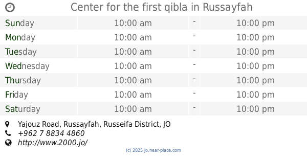
Center for the first qibla
Yajouz Road, Russayfah
School
read more
934 m
المدرسة النظامية الأهلية
Russayfah
School
read more
959 m
مدرسة اسامه
Russayfah
School
read more
1.023 km
مدرسة صلاح الدين الايوبي
Russayfah
School
read more
1.086 km
Goman School
Russayfah
School
read more
1.128 km
مدرسة جمانة بنت عبد المطلب
Russayfah
School
read more
1.135 km
Jumana girl Abdul Muttalib School
Russayfah
School
read more
1.179 km
مدرسة نور الفكر الجبل الشمالي
Russayfah
School
read more
1.543 km
مدرسة واحة المعارف
Russayfah
School
read more
1.56 km
مدرسة عائشة بنت ابي بكر الاساسية
Unnamed Road، الرصيفة،
School
read more
1.634 km
مدرسة البيروني الرصيفة
Hizam Ring Road, Russayfah
School
read more
1.864 km
Noor Al-Qabas Model School Advanced
Yajouz Road, Az-Zarqa
School
read more
1.991 km
روضة المسبحين الاسلامية
Russayfah
School
read more
2.318 km
Zarkas
Russayfah
School
read more
📑
all categories
Accounting
Administrative area level 1
Administrative area level 2
Airport
Amusement park
Aquarium
Art gallery
Atm
Bakery
Bank
Bar
Beauty salon
Bicycle store
Book store
Bowling alley
Bus station
Cafe
Campground
Car dealer
Car rental
Car repair
Car wash
Cemetery
Church
City hall
Clothing store
Colloquial area
Convenience store
Country
Courthouse
Dentist
Department store
Doctor
Electrician
Electronics store
Embassy
Finance
Fire station
Florist
Food
Funeral home
Furniture store
Gas station
General contractor
Grocery or supermarket
Gym
Hair care
Hardware store
Health
Home goods store
Hospital
Insurance agency
Jewelry store
Laundry
Lawyer
Library
Liquor store
Local government office
Locality
Locksmith
Lodging
Meal delivery
Meal takeaway
Mosque
Movie rental
Movie theater
Moving company
Museum
Natural feature
Neighborhood
Night club
Painter
Park
Parking
Pet store
Pharmacy
Physiotherapist
Place of worship
Plumber
Point of interest
Police
Post office
Premise
Real estate agency
Restaurant
Route
Rv park, camping
School
Shoe store
Shopping mall
Spa
Stadium
Storage
Store
Supermarket
Taxi stand
Train station
Travel agency
University
Veterinary care
Zoo
sublocality level 1
↑