School nearby مدرسة وروضة الفرائد التربوية
Jordan
School nearby مدرسة وروضة الفرائد التربوية
مدرسة وروضة الفرائد التربوية
אירביד, ירדן
contacts phone
:
+962
Latitude:
32.5916775
, Longitude:
35.9183145
larger map & directions
read more
nearest School
1.222 km
Rahob Elementary School for Girls
المغير, Irbid
School
read more
1.249 km
مدارس أكاديمية التفاعل النموذجية
اربد - المغير راحوب دوار الشهيد, وصفي التل, Irbid
School
read more
1.263 km
مدرسة جعفر الطيار التربوية الخاصة
لواء قصبة اربد،
School
read more
2.51 km
مدرسة المغير الثانوية الشاملة للبنات
لواء قصبة اربد،
School
read more
2.511 km
Hussein Secondary School for Boys
School
read more
2.689 km
مدرسة المغير الثانوية للبنين
School
read more
2.948 km
مسجد المؤاخاة
Al-Shahid Road, Amman
School
read more
3.142 km
MRO Elementary Boys School
شارع عيسى النعمان, Irbid
School
read more
3.306 km
MRO Elementary Boys School
لواء قصبة اربد, Maru
School
read more
3.796 km
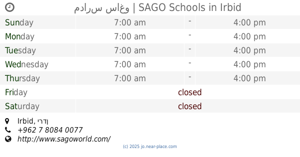
مدارس ساغو | SAGO Schools
Irbid
School
read more
3.804 km
SAGO School
Hizam Ring Road, Amman
School
read more
3.946 km
Mindfulness School
School
read more
3.962 km
Girl's School
Alal
School
read more
4.696 km
Shymaa Elementary School
Irbid، Qasabah District
School
read more
4.93 km
Apostles School of Educational Excellence
Irbid
School
read more
4.947 km
مدرسة حديقة تونس الأساسية للبنات
Irbid
School
read more
5.214 km
Basic School Harima Mixed
School
read more
5.407 km
School
Al Muwahidin, Irbid
School
read more
5.472 km
Basic dignity school district
Irbid
School
read more
5.872 km
Fatima Zahra Secondary School for Girls
Irbid
School
read more
5.989 km
School
Samar Street, Irbid
School
read more
6.157 km
Educational Excellence Academy Schools
Irbid
School
read more
6.674 km
حضانة زهرة تشرين
Mutah Street, Irbid
School
read more
6.82 km
اكاديميةالاسس النموذجية
Halab Street, Irbid
School
read more
6.945 km
مدرسة القادسية الأساسية للبنات
Al Madina Al Munawara, Irbid
School
read more
📑
all categories
Accounting
Administrative area level 1
Administrative area level 2
Airport
Amusement park
Aquarium
Art gallery
Atm
Bakery
Bank
Bar
Beauty salon
Bicycle store
Book store
Bowling alley
Bus station
Cafe
Campground
Car dealer
Car rental
Car repair
Car wash
Cemetery
Church
City hall
Clothing store
Colloquial area
Convenience store
Country
Courthouse
Dentist
Department store
Doctor
Electrician
Electronics store
Embassy
Finance
Fire station
Florist
Food
Funeral home
Furniture store
Gas station
General contractor
Grocery or supermarket
Gym
Hair care
Hardware store
Health
Home goods store
Hospital
Insurance agency
Jewelry store
Laundry
Lawyer
Library
Liquor store
Local government office
Locality
Locksmith
Lodging
Meal delivery
Meal takeaway
Mosque
Movie rental
Movie theater
Moving company
Museum
Natural feature
Neighborhood
Night club
Painter
Park
Parking
Pet store
Pharmacy
Physiotherapist
Place of worship
Plumber
Point of interest
Police
Post office
Premise
Real estate agency
Restaurant
Route
Rv park, camping
School
Shoe store
Shopping mall
Spa
Stadium
Storage
Store
Supermarket
Taxi stand
Train station
Travel agency
University
Veterinary care
Zoo
sublocality level 1
↑